Lazaropole
| Lazaropole Лазарополе | |
|---|---|
|
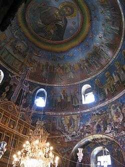
Church in Lazaropole | |
 Lazaropole Location within Macedonia | |
| Coordinates: 41°32′10″N 20°41′38″E / 41.53611°N 20.69389°ECoordinates: 41°32′10″N 20°41′38″E / 41.53611°N 20.69389°E | |
| Country |
|
| Municipality | Mavrovo and Rostuša |
| Time zone | CET (UTC+1) |
| • Summer (DST) | CEST (UTC+2) |
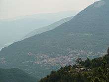
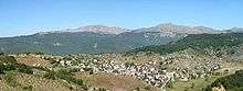
Lazaropole (Macedonian: Лазарополе) is a village in the Municipality of Mavrovo and Rostuša, Republic of Macedonia. Situated on a plateau at Mount Bistra and surrounded by beech and oak forest; at 1,350 m altitude, it is one of the highest settlements in the country.
The village is named after a local medieval hero, Lazar, who according to legend was the sole survivor of a Turkish attack on his village. The rest of the townspeople were killed in a cave where they had sought refuge, while Lazar, the only survivor, crawled outside and built a new town.
There are about 400 houses in the village. The older ones reveal the traces of the Mijaci highland building style. The village was the birthplace of numerous authors, educators, carvers, teachers, fresco and icon painters, and constructors . Especially picturesque are the village church of St. George, built in 1838, and the small churches in the forests near the village.
Climate
| Climate data for Lazaropole (1961–1990) | |||||||||||||
|---|---|---|---|---|---|---|---|---|---|---|---|---|---|
| Month | Jan | Feb | Mar | Apr | May | Jun | Jul | Aug | Sep | Oct | Nov | Dec | Year |
| Average high °C (°F) | 2.2 (36) |
3.0 (37.4) |
6.1 (43) |
10.6 (51.1) |
15.5 (59.9) |
18.9 (66) |
22.2 (72) |
22.3 (72.1) |
18.7 (65.7) |
13.3 (55.9) |
8.0 (46.4) |
4.0 (39.2) |
12.1 (53.8) |
| Daily mean °C (°F) | −1.9 (28.6) |
−1.5 (29.3) |
1.4 (34.5) |
5.6 (42.1) |
10.4 (50.7) |
13.6 (56.5) |
16.0 (60.8) |
15.5 (59.9) |
12.2 (54) |
7.7 (45.9) |
3.4 (38.1) |
−0.5 (31.1) |
6.8 (44.2) |
| Average low °C (°F) | −5.9 (21.4) |
−5.0 (23) |
−2.8 (27) |
1.1 (34) |
5.0 (41) |
7.8 (46) |
9.4 (48.9) |
9.4 (48.9) |
7.0 (44.6) |
3.5 (38.3) |
0.0 (32) |
−3.9 (25) |
2.1 (35.8) |
| Average precipitation mm (inches) | 103.8 (4.087) |
94.8 (3.732) |
99.2 (3.906) |
85.6 (3.37) |
87.1 (3.429) |
59.2 (2.331) |
46.8 (1.843) |
50.8 (2) |
68.2 (2.685) |
95.5 (3.76) |
145.3 (5.72) |
130.8 (5.15) |
1,067.1 (42.012) |
| Average precipitation days (≥ 1.0 mm) | 11 | 11 | 11 | 11 | 10 | 8 | 5 | 6 | 6 | 8 | 11 | 12 | 110 |
| Average relative humidity (%) | 79 | 78 | 74 | 71 | 71 | 71 | 67 | 69 | 73 | 75 | 77 | 80 | 74 |
| Mean monthly sunshine hours | 104.2 | 105.7 | 140.8 | 161.6 | 197.3 | 223.9 | 289.4 | 274.0 | 225.5 | 172.6 | 117.8 | 83.4 | 2,106.2 |
| Source: NOAA[1] | |||||||||||||
Culture
The traditional Macedonian folk dance Teškoto is from the area of Lazaropole.
People born in Lazaropole
- Golub Janić, Macedonian Serb
- Simon Drakul, Macedonian writer
- Ante Popovski, Macedonian writer
- Gjurčin Kokaleski
- Anatolij Zografski
- Vasil Ikonomov
- Mate Grujovski
See also
References
- ↑ "Lazaropole Climate Normals 1961–1990". National Oceanic and Atmospheric Administration. Retrieved 1 April 2016.