Le Breuil-sous-Argenton
| Le Breuil-sous-Argenton | |
|---|---|
|
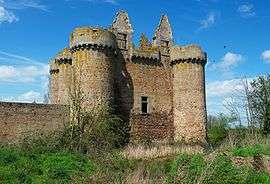
The Chateau of L'Ebaupinay | |
 Le Breuil-sous-Argenton | |
|
Location within Nouvelle-Aquitaine region  Le Breuil-sous-Argenton | |
| Coordinates: 46°59′36″N 0°25′47″W / 46.9933°N 0.4297°WCoordinates: 46°59′36″N 0°25′47″W / 46.9933°N 0.4297°W | |
| Country | France |
| Region | Nouvelle-Aquitaine |
| Department | Deux-Sèvres |
| Arrondissement | Bressuire |
| Canton | Argenton-les-Vallées |
| Government | |
| • Mayor (2008–2014) | Michel Brebion |
| Area1 | 19.55 km2 (7.55 sq mi) |
| Population (2006)2 | 411 |
| • Density | 21/km2 (54/sq mi) |
| Time zone | CET (UTC+1) |
| • Summer (DST) | CEST (UTC+2) |
| INSEE/Postal code | 79053 / 79150 |
| Elevation |
67–157 m (220–515 ft) (avg. 117 m or 384 ft) |
|
1 French Land Register data, which excludes lakes, ponds, glaciers > 1 km² (0.386 sq mi or 247 acres) and river estuaries. 2 Population without double counting: residents of multiple communes (e.g., students and military personnel) only counted once. | |
Le Breuil-sous-Argenton is a former commune in the Deux-Sèvres department in western France. On 1 January 2016, it was merged into the new commune Argentonnay.[1]
See also
References
- ↑ Arrêté préfectoral 17 November 2015 (French)
| Wikimedia Commons has media related to Le Breuil-sous-Argenton. |
This article is issued from Wikipedia - version of the 11/19/2016. The text is available under the Creative Commons Attribution/Share Alike but additional terms may apply for the media files.