Le Mesnil-Garnier
| Le Mesnil-Garnier | |
|---|---|
|
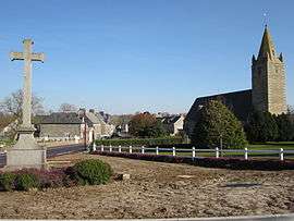
View of the village from the entrance | |
 Le Mesnil-Garnier | |
|
Location within Normandy region  Le Mesnil-Garnier | |
| Coordinates: 48°51′57″N 1°18′30″W / 48.8658°N 1.3083°WCoordinates: 48°51′57″N 1°18′30″W / 48.8658°N 1.3083°W | |
| Country | France |
| Region | Normandy |
| Department | Manche |
| Arrondissement | Coutances |
| Canton | Gavray |
| Intercommunality | Communauté de communes du canton de Gavray |
| Government | |
| • Mayor (2008–2014) | Annick Villain |
| Area1 | 10.41 km2 (4.02 sq mi) |
| Population (2006)2 | 223 |
| • Density | 21/km2 (55/sq mi) |
| Time zone | CET (UTC+1) |
| • Summer (DST) | CEST (UTC+2) |
| INSEE/Postal code | 50311 / 50450 |
| Elevation |
73–166 m (240–545 ft) (avg. 30 m or 98 ft) |
|
1 French Land Register data, which excludes lakes, ponds, glaciers > 1 km² (0.386 sq mi or 247 acres) and river estuaries. 2 Population without double counting: residents of multiple communes (e.g., students and military personnel) only counted once. | |
Le Mesnil-Garnier is a commune in the Manche department in Normandy in north-western France.
See also
| Wikimedia Commons has media related to Le Mesnil-Garnier. |
This article is issued from Wikipedia - version of the 3/1/2015. The text is available under the Creative Commons Attribution/Share Alike but additional terms may apply for the media files.