Lelley

Coordinates: 53°46′31″N 0°09′59″W / 53.775395°N 0.166441°W
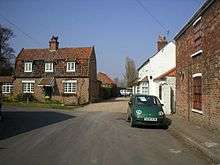
Lelley is a small village in the East Riding of Yorkshire, England, in an area known as Holderness. It is situated approximately 7 miles (11 km) north-east of Hull city centre and 3 miles (5 km) north of Hedon.
The village forms part of the civil parish of Elstronwick.
Lelley comes from the word 'Lelle' which means 'clearing in the woods'.
The village contains a public house, two benches (one a war memorial and the other a millennium bench) and a telephone box.
Lelley Wesleyan Methodist Church was demolished in the late 19th century.
In 1823 Lelly was in the parish of Preston and the Wapentake and Liberty of Holderness. Population was 119, which included a carrier who operated between the village and Hull once a week.[1]
References
- ↑ Baines, Edward (1823): History, Directory and Gazetteer of the County of York, p. 363
- Gazetteer — A–Z of Towns Villages and Hamlets. East Riding of Yorkshire Council. 2006. p. 7.
External links
 Media related to Lelley at Wikimedia Commons
- Lelley in the Domesday Book