Libby Island Light
 US Coast Guard photo | |
 | |
| Location | Machias Bay, Maine |
|---|---|
| Coordinates | 44°34′5.985″N 67°22′2.555″W / 44.56832917°N 67.36737639°WCoordinates: 44°34′5.985″N 67°22′2.555″W / 44.56832917°N 67.36737639°W |
| Year first constructed | 1822 |
| Year first lit | 1848 (current structure) |
| Automated | 1974 |
| Tower shape | Conical Granite Tower |
| Markings / pattern | White |
| Focal height | 91 feet (28 m) |
| Original lens | 4th order Fresnel lens |
| Current lens | VRB-25 |
| Range | 18 nautical miles (33 km; 21 mi) |
| Characteristic | Fl (2) W 20s |
| Fog signal | HORN: 1 every 15s |
| USCG number | |
|
Libby Island Light Station | |
| Nearest city | Machiasport, Maine |
| Built | 1822 |
| NRHP Reference # | 76000117[4] |
| Added to NRHP | June 18, 1976 |
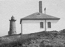
Libby Island Light is a lighthouse on Libby Island, marking the mouth of Machias Bay, in Machiasport, Maine. The light station was established in 1817 and is an active aid to navigation; the present granite tower was built in 1823 and improved in 1848. Libby Island Light was listed on the National Register of Historic Places as Libby Island Light Station on June 18, 1976.[4]
Description and history
Libby Island Light is located on South Libby Island, one of two islands (collectively known as the Libby Islands) marking the southernmost approach to Machias Bay on the northeastern coast of Maine. The light station's principal feature is the lighthouse, an unpainted conical granite tower 42 feet (13 m) in height, with its base 16 feet (4.9 m) in diameter and its upper parapet 12 feet 4 inches (3.76 m) in diameter. The tower is located on the southern shore of the island, with a fog signal house to its west. A boat landing is located on the northern shore of the island, and a small helipad is near its center.[5]
The light station was authorized in 1817, and its first tower was a wood frame structure that was blown down about 1822. The present tower was built in 1823,[1] and a keeper's house added the following year.[5] A fourth-order Fresnel lens was installed in the tower in 1855, and a fog signal and several outbuildings (like the keeper's house since demolished) were built the following year. The present fog signal house was built in 1884. The light was automated in 1974, and converted to solar power in 2000.[1] The tower is now the property of the United States Fish and Wildlife Service, and is not open to the public.
See also
References
- 1 2 3 "Historic Light Station Information and Photography: Maine". United States Coast Guard Historian's Office. 2009-08-06.
- ↑ Light List, Volume I, Atlantic Coast, St. Croix River, Maine to Shrewsbury River, New Jersey (PDF). Light List. United States Coast Guard. 2009. p. 13.
- ↑ Rowlett, Russ (2009-10-09). "Lighthouses of the United States: Eastern Maine". The Lighthouse Directory. University of North Carolina at Chapel Hill.
- 1 2 National Park Service (2009-03-13). "National Register Information System". National Register of Historic Places. National Park Service.
- 1 2 "NRHP nomination for Libby Island Light" (PDF). National Park Service. Retrieved 2015-10-16.

| Topics | |
|---|---|
| Lists by states |
|
| Lists by insular areas | |
| Lists by associated states | |
| Other areas | |
| |