Lillebonne
| Lillebonne | ||
|---|---|---|
|
Roman theater | ||
| ||
 Lillebonne | ||
|
Location within Normandy region  Lillebonne | ||
| Coordinates: 49°31′08″N 0°32′03″E / 49.5189°N 0.5343°ECoordinates: 49°31′08″N 0°32′03″E / 49.5189°N 0.5343°E | ||
| Country | France | |
| Region | Normandy | |
| Department | Seine-Maritime | |
| Arrondissement | Le Havre | |
| Canton | Lillebonne | |
| Intercommunality | Caux-Vallée de Seine | |
| Government | ||
| • Mayor (2008–2013) | Nicolas Beaussart | |
| Area1 | 14.66 km2 (5.66 sq mi) | |
| Population (2006)2 | 9,866 | |
| • Density | 670/km2 (1,700/sq mi) | |
| Time zone | CET (UTC+1) | |
| • Summer (DST) | CEST (UTC+2) | |
| INSEE/Postal code | 76384 / 76170 | |
| Elevation |
0–1,338 m (0–4,390 ft) (avg. 6 m or 20 ft) | |
|
1 French Land Register data, which excludes lakes, ponds, glaciers > 1 km² (0.386 sq mi or 247 acres) and river estuaries. 2 Population without double counting: residents of multiple communes (e.g., students and military personnel) only counted once. | ||
Lillebonne is a commune in the Seine-Maritime department in the Haute-Normandie region in northern France. It lies 3.5 miles (5.6 km) miles north of the Seine and 24 miles (39 km) east of Le Havre.
History
Before the Roman conquest of Gaul Juliobona was the capital of the Caletes, or inhabitants of the Pays de Caux. It was destroyed by Julius Caesar and afterwards rebuilt by Augustus. Before it was again ruined by the barbarian invasions, it had become an important centre whence Roman roads branched out in all directions. It was an administrative, military and commercial city located close to the Seine. This made it a great transportation route between Brittany (current England) and the remainder of the Roman Empire. It was also a crossroads of communication in order to bring Roman ways to Harfleur, Étretat, Dieppe, Évreux and Rouen.
The remains of Roman baths and of a theater capable of holding 3,000 persons have been brought to light. Many Roman and Gallic relics, notably a bronze statue of Apollo (exposed in Le Louvre), and two fine mosaics exposed to the museum at Rouen, have been found. In the Middle Ages the fortifications of the town were constructed out of materials supplied by the Roman theater. The town recovered some of its old importance under William the Conqueror.
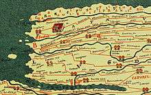 Detail of the Tabula Peutingeriana from 1st-4th century, (Juliobona is at the center)
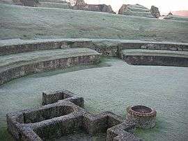 Roman theatre of Lillebonne
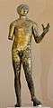 Apollo found at Lillebonne, bronze statue from 2nd century, museum of Le Louvre (Paris)
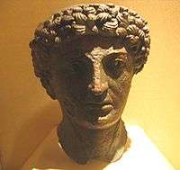 Bronze head romain god, found at Lillebonne, Musée des antiquités of the Seine-Maritime (Rouen)
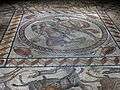 Mosaic of Orpheus found at Lillebonne, Musée des antiquités of the Seine-Maritime (Rouen)
Geography
Lillebonne lies in the valley of the Bolbec River at the foot of wooded hills at the junction of the D982, D29 and the D81 roads.,
Sights
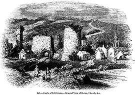
The church of Notre Dame, partly modern, preserves a Gothic portal of the 16th century and a graceful tower of the same period. The park contains a fine cylindrical donjon and other remains of a castle founded by William the Conqueror and rebuilt in the 13th century.
The Gallo-Roman amphitheater of Lillebonne was built in the first century and was altered in the second century so that it could be used as both an amphitheater and a theater. Part of its remains are still visible today from Félix Faur Square, and the foundations of some of its remnants (the wings and backdrop) remain under the square.
Economy
The principal industries were cotton-spinning and the manufacture of calico and candles. Petrochemistry is now the main industry in the area, with a part of the nearby Notre-Dame-de-Gravenchon refining and petrochemical complex extending over the Lillebonne commune.
Twin towns
See also
References
- INSEE
 This article incorporates text from a publication now in the public domain: Chisholm, Hugh, ed. (1911). "article name needed". Encyclopædia Britannica (11th ed.). Cambridge University Press.
External links
| Wikimedia Commons has media related to Lillebonne. |
- Tourism office of Lillebonne (French)