Lira Airport
| Lira Airport | |||||||||||
|---|---|---|---|---|---|---|---|---|---|---|---|
| IATA: none – ICAO: HULI | |||||||||||
| Summary | |||||||||||
| Airport type | Public | ||||||||||
| Owner | Civil Aviation Authority of Uganda | ||||||||||
| Serves | Lira, Uganda | ||||||||||
| Elevation AMSL | 3,580 ft / 1,091 m | ||||||||||
| Coordinates | 2°14′52″N 32°54′35″E / 2.24778°N 32.90972°ECoordinates: 2°14′52″N 32°54′35″E / 2.24778°N 32.90972°E | ||||||||||
| Map | |||||||||||
 HULI Location of the airport in Uganda | |||||||||||
| Runways | |||||||||||
| |||||||||||
Lira Airport (ICAO: HULI) is an airport serving Lira, a town in the Lira District of Uganda. Lira Airport is one of twelve upcountry airports that are administered by the Civil Aviation Authority of Uganda.[1][4] It is also one of the 46 airports in the country.[5]
Location
Lira Airport is in northern Uganda, approximately 250 kilometres (160 mi) by air, north of Entebbe International Airport, the country’s largest civilian and military airport.[6]
See also
References
- 1 2 Lira Airfield, Uganda Civil Aviation Authority, 25 February 2014, accessed 15 November 2015
- ↑ Google Maps - Lira
- ↑ Airport information for HULI at Great Circle Mapper.
- ↑ Uganda CAA dropdown list of airfields
- ↑ "Uganda". CIA World Factbook.
Airports: 46 (2010)
- ↑ "Distance between Entebbe and Lira with map". Distance Calculator. Globefeed.com. Retrieved 9 March 2010.
249.2 km (approximate travel/road distance 286.6 km to 311.6 km)
External links
Capital: Lira | ||
| Counties and sub-counties | Otuke County | 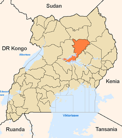 |
| Towns and villages | ||
| Economy | ||
| Industry | ||
| Transport | ||
| Energy | ||
| Notable landmarks | ||
| Health |
| |
| Education | ||
| Notable people | ||
This article is issued from Wikipedia - version of the 9/26/2016. The text is available under the Creative Commons Attribution/Share Alike but additional terms may apply for the media files.