List of Cultural Properties of Japan - historical materials (Kanagawa)
This list is of the Cultural Properties of Japan designated in the category of historical materials (歴史資料 rekishi shiryō) for the Prefecture of Kanagawa.[1]
National Cultural Properties
As of 1 August 2015, six Important Cultural Properties have been designated, being of national significance.[2][3][4]
| Property | Date | Municipality | Ownership | Comments | Image | Coordinates | Ref. |
|---|---|---|---|---|---|---|---|
| Steam hammers from the former Yokosuka Ironworks スチームハンマー(旧横須賀製鉄所設置)〈/一八六五年、オランダ製〉 suchīmu hanmā (kyū-Yokosuka seitetsusho setchi) | 1865 | Yokosuka | Verny Memorial Museum (ヴェルニー記念館) | two machines; manufactured in the Netherlands | 35°17′05″N 139°39′22″E / 35.28474902°N 139.65597693°E | ||
| The film "Farewell of Nanko" 映画フィルム「楠公訣別」 eiga firumu Nankō ketsubetsu | 1920-28 | Sagamihara | Sagamihara Branch, National Film Centre, National Museum of Modern Art, Tokyo | one roll | 35°33′36″N 139°23′39″E / 35.55991848°N 139.3942451°E | ||
| Images from the construction of the Engaku-ji Butsuden 円覚寺仏殿造営図 Engakuji Butsuden zōei zu | 1573 | Kamakura | Kamakura Museum of National Treasures | two items | 35°19′29″N 139°33′26″E / 35.32464237°N 139.55709929°E | ||
| Daguerreotype of Endō Matazaemon and retainers, by Eliphalet Brown, Jr. 銀板写真(遠藤又左衛門と従者像)〈エリファレット・ブラウン・ジュニア撮影/一八五四年〉 ginban shashin (Endō Matazaemon to jūnsha zō) (Erifaretto Buraun junia satsuei 1854 nen) | 1854 | Yokohama | Yokohama Museum of Art | one image | .png) | 35°27′25″N 139°37′50″E / 35.4570761°N 139.63055804°E | |
| Plan of Tsurugaoka Hachimangū 鶴岡八幡宮指図〈/天正十九年五月十四日〉 Tsuruoka hachimangū sashizu (Tenshō jūkunen gogatsu jūyōka) | 1591 | Kamakura | Tsurugaoka Hachimangū | .jpg) | 35°19′34″N 139°33′23″E / 35.326067°N 139.556418°E | ||
| Map of Japan 日本図(遠江、越後以東欠) Nihon zu (Tōtōmi, Echigo itō ketsu) | Kamakura period | Yokohama | Shōmyō-ji (称名寺) (kept at Kanazawa Bunko) | half of the map, east of Tōtōmi and Echigo Provinces, is missing | 35°20′38″N 139°37′43″E / 35.34392186°N 139.62870897°E | ||
Prefectural Cultural Properties
As of September 2014, one property has been designated at a prefectural level.[4][5]
| Property | Date | Municipality | Ownership | Comments | Image | Coordinates | Ref. |
|---|---|---|---|---|---|---|---|
| Materials relating to Ninomiya Sontoku 二宮尊徳関係資料 Ninomiya Sontoku kankei shiryō | Edo period | Odawara | Hōtoku Museum (報徳博物館), Sontoku Memorial Museum (尊徳記念館), Hōtoku Ninomiya Jinja (報徳二宮神社) | 3,872 items | .jpg) | 35°14′56″N 139°09′12″E / 35.248944°N 139.153469°E | |
| Hokkaidō | 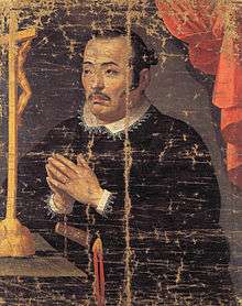 | |
|---|---|---|
| Tōhoku |
| |
| Kantō | ||
| Chūbu | ||
| Kansai | ||
| Chūgoku |
| |
| Shikoku | ||
| Kyūshū | ||
| Okinawa | ||
1 | ||
See also
- Cultural Properties of Japan
- List of Historic Sites of Japan (Kanagawa)
- Sagami Province, Musashi Province
- Kanagawa Prefectural Museum of Cultural History
- List of National Treasures of Japan (historical materials)
- List of Cultural Properties of Japan - paintings (Kanagawa)
References
- ↑ "Pamphlet on Cultural Properties". Agency for Cultural Affairs. Retrieved 22 August 2015.
- ↑ 国宝・重要文化財 [Number of National Treasures and Important Cultural Properties by Prefecture] (in Japanese). Agency for Cultural Affairs. 1 August 2015. Retrieved 22 August 2015.
- ↑ 国宝・重要文化財(美術品)(歴史資料 神奈川県) [Database of National Cultural Properties] (in Japanese). Agency for Cultural Affairs. Retrieved 22 August 2015.
- 1 2 神奈川県文化財目録 [Inventory of Cultural Properties of Kanagawa Prefecture] (PDF). Kanagawa Prefecture. September 2014. Retrieved 22 August 2015.
- ↑ 都道府県別指定等文化財件数(都道府県分) [Number of Prefectural Cultural Properties by Prefecture] (in Japanese). Agency for Cultural Affairs. 1 May 2014. Retrieved 22 August 2015.
External links
- (Japanese) Cultural Properties in Kanagawa Prefecture
- (Japanese) List of Cultural Properties in Kanagawa Prefecture
This article is issued from Wikipedia - version of the 9/8/2016. The text is available under the Creative Commons Attribution/Share Alike but additional terms may apply for the media files.