List of Cultural Properties of Japan - structures (Okinawa)
This list is of the Cultural Properties of Japan designated in the category of structures (建造物 kenzōbutsu) for the Prefecture of Okinawa.[1]
National Cultural Properties
As of 1 January 2015, twenty-one Important Cultural Properties with thirty-eight component structures have been designated, being of national significance.[2][3][4]
| Property | Date | Municipality | Comments | Image | Coordinates | Ref. |
|---|---|---|---|---|---|---|
| Ieudun Tomb 伊江御殿墓 Ieudun baka | 1687 | Naha | turtle-back tomb of the Ie line, descendants of the seventh son of Shō Sei, fourth king of the Second Shō Dynasty | 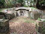 | 26°13′33″N 127°43′32″E / 26.22596772°N 127.72566544°E | |
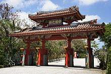
| Sonohyan-utaki Stone Gate 園比屋武御嶽石門 Sonohyan-utaki sekimon | 1519 | Naha | heavily damaged during the war and restored to its previous form in 1957; part of the Prefectural Historic Site and of the UNESCO World Heritage Site Gusuku Sites and Related Properties of the Kingdom of Ryukyu.[5] | 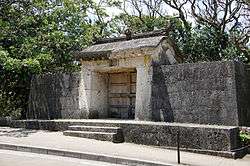 | 26°13′05″N 127°43′02″E / 26.21812186°N 127.71729951°E | |
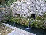
| Chunnaagaa 喜友名泉 Chunnaagaa | 1751-1829 | Ginowan | stone castellum aquae or fountain | 26°17′16″N 127°45′37″E / 26.28783779°N 127.76040657°E | ||
| Former Enkaku-ji Hōjō Bridge 旧円覚寺放生橋 kyū-Engakuji Hōjō-bashi | 1498 | Naha | Enkaku-ji was founded by Shō Shin in 1492; all its wooden buildings were destroyed during the war; the ornately-carved bridge suffered minor damage and has since been restored; its carvings are a Prefectural Cultural Property | 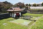 | 26°13′06″N 127°43′09″E / 26.21846412°N 127.71919986°E | |
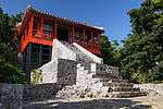
| Miyaradunchi 旧宮良殿内 kyū-Miyaradunchi | 1751-1829 | Ishigaki | residence of a senior Pechin; the gardens are a Place of Scenic Beauty | 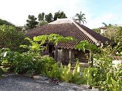 | 24°20′28″N 124°09′35″E / 24.34114951°N 124.15969964°E | |
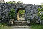
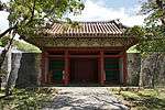
| Former Sōgen-ji First Gate and Stone Wall 旧崇元寺第一門及び石牆 kyū-Sōgenji daiichimon oyobi sekishō | before 1527 | Naha | Sōgenji, said to have been founded in 1470, was destroyed during the war; the gate was restored in 1952 | 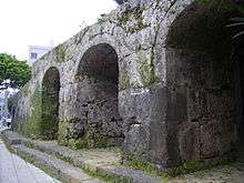 | 26°13′13″N 127°41′26″E / 26.22034995°N 127.69058729°E | |
| Former Nakazato Magiri Warehouse Overseer's Stone Walls 旧仲里間切蔵元石牆 kyū-Nakazato magiri kuramoto sekishō | 1716-1735 | Kumejima | the wooden buildings are lost | 26°21′16″N 126°48′28″E / 26.35452639°N 126.80777485°E | ||
| Former Yonaguni Family Residence 旧与那国家住宅 kyū-Yonaguni-ke jūtaku | 1913 | Taketomi | part of the Taketomi Preservation District for Groups of Traditional Buildings | 24°19′43″N 124°05′15″E / 24.32862545°N 124.08743913°E | ||
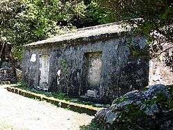
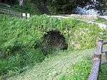
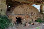
| Former Waukei Family Tomb 旧和宇慶家墓 kyū-Waukei-ke haka | 1601-1700 | Ishigaki | combines a roofed cave burial chamber with a walled courtyard | 24°21′48″N 124°09′54″E / 24.36324145°N 124.16496877°E | ||
| Tamaudun 玉陵 Tamaudun | 1501 | Naha | designation comprises five components: the central chamber for temporary burial prior to washing the bones and final entombment, east chamber for the entombment of kings and queens, west chamber for the entombment of other members of the royal family, and inner and outer stone walls; also an Historic Site and part of the UNESCO World Heritage Site Gusuku Sites and Related Properties of the Kingdom of Ryukyu[5] | 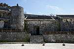 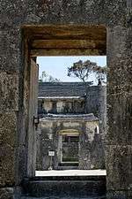 | 26°13′05″N 127°42′53″E / 26.218164°N 127.714726°E | |
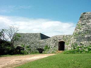
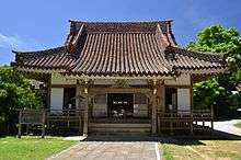
| Gongen-dō 権現堂 Gongendō | 1786 | Ishigaki | designation comprises two components: the shinden and haiden; first constructed in 1614, destroyed by the 1771 Great Yaeyama Tsunami, and rebuilt the following decade |  | 24°20′37″N 124°09′21″E / 24.34354062°N 124.15595923°E | |
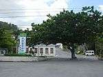
| Takara Family Residence 高良家住宅 Takara-ke jūtaku | 1868-1911 | Zamami | boatman's house on Geruma Island |  | 26°10′38″N 127°17′35″E / 26.1771063°N 127.29301123°E | |
| Uezu Family Residence 上江洲家住宅 Uezu-ke jūtaku | 1754 | Kumejima | designation comprises two components: the main building and anteroom | 26°21′18″N 126°44′56″E / 26.35507887°N 126.7489287°E | ||
| Aragaki Family Residence 新垣家住宅 主屋 Aragaki-ke jūtaku omoya | 1801-1911 | Naha | designation comprises four components: the nineteenth-century main building and workshop, and the 1911 annex and climbing kiln; a potter's house (tsuboya-yaki (壺屋焼)) |  | 26°12′45″N 127°41′35″E / 26.2125881°N 127.69294522°E | |
| Sesoko Toteikun 瀬底土帝君 Sesoko tōteīkun | late Edo period | Motobu | on Sesokojima (瀬底島); complex includes honden, haiden, garden, stone walls, hearth | 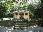 | 26°38′37″N 127°51′53″E / 26.64373613°N 127.86485299°E | |
| Nakamura Family Residence 中村家住宅 Nakamura-ke jūtaku | late Edo to Meiji period | Kitanakagusuku | designation comprises five components: the main building (late Edo to Meiji period), anteroom, annexe, storehouse, and pigpen or fuuru (all Meiji period) | 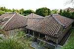 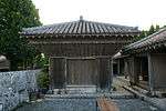 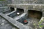 | 26°17′24″N 127°48′02″E / 26.28989041°N 127.80067679°E | |
| Nakandakari Riverside Facilities 仲村渠樋川 Nakandakari hiijaa | 1912 | Nanjō | amenities include a fountain, retaining walls, pavements etc. | 26°08′43″N 127°47′34″E / 26.14537598°N 127.7929062°E | ||
| Tsukayama Distillery 津嘉山酒造所施設 Tsukayama shuzōsho shisetsu | 1928 | Nago | awamori distillery; designation comprises two components: the main building and distillery | 26°35′29″N 127°59′00″E / 26.59149628°N 127.98321166°E | ||
| Tennyo Bridge 天女橋 Tennyo bashi | 1502 | Naha | located in Shuri Castle Park named after the tennyo | 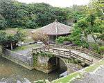 | 26°13′07″N 127°43′07″E / 26.21850051°N 127.71867824°E | |
| Tōyumya Tombs 豊見親墓 Tōyumya baka | late Edo period | Hirara | designation comprises three components: the tomb of sixteenth-century chieftain Nakasone Toyomiya, of his third son Chirimara Toyomiya (知利真良豊見親), and of Atonma (あとんま) | 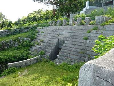 | 24°48′31″N 125°16′47″E / 24.80870299°N 125.27979091°E | |
| Mekaru Family Residence 銘苅家住宅 Mekaru-ke jūtaku | 1906 | Izena | designation comprises two components: the main building and annexe | 26°55′04″N 127°56′05″E / 26.91767404°N 127.93477092°E | ||
Prefectural Cultural Properties
As of 1 May 2014, twenty properties have been designated at a prefectural level.[4][6]
Municipal Cultural Properties
As of 1 May 2014, thirty-four properties have been designated at a municipal level.[4][8]
Registered Cultural Properties
As of 1 January 2015, seventy-seven properties at thirty-one sites have been registered (as opposed to designated) at a national level.[4][11]
| Property | Date | Municipality | Comments | Image | Coordinates | Ref. |
|---|---|---|---|---|---|---|
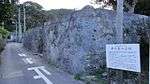
| Sunjagā 潮平ガー Sunjagā | Taishō period | Itoman | 26°08′37″N 127°40′38″E / 26.14357724°N 127.67708825°E | |||
| Minamidaitōjima West Port Former Boiler Hut 南大東島西港旧ボイラー小屋 Minamidaitōjima Nishikō kyū-boirā koya | 1924 | Minamidaitō | 25°50′33″N 131°13′05″E / 25.84261309°N 131.2180888°E | |||
| Kinjō Masuharu Family Residence 金城増治家住宅 Kinjō Masuharu-ke jūtaku | 1891 | Itoman | four registrations: main residence, pigpen, well, and stone wall | 26°06′20″N 127°41′29″E / 26.10556641°N 127.69142986°E | ||
| Kamiyama Family Residence 神山家住宅 Kamiyama-ke jūtaku | 1909-38 | Taketomi | four registrations: well and stone wall (1909), main residence (1912), and water tank (1938) | 24°14′08″N 124°00′47″E / 24.23549194°N 124.01308122°E | ||
| Former Tōyō Sugar Kitadaitō Branch 旧東洋製糖北大東出張所 kyū-Tōyō Seitō Kitadaitō shutchōjo | 1918 | Kitadaitō | 25°57′15″N 131°17′11″E / 25.95424453°N 131.28637094°E | |||
| West Pier 西桟橋 nishi sanbashi | 1938 | Taketomi | length of 105 metres (344 ft) and width of 4.4 metres (14 ft) | 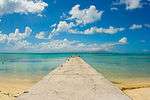 | 24°19′54″N 124°04′47″E / 24.33157854°N 124.07977292°E | |
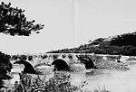
| Iko Pier 伊古桟橋 Iko sanbashi | 1935 | Taketomi | length of 354 metres (1,161 ft) and width of 4.5 metres (15 ft) | 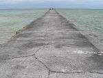 | 24°14′47″N 124°00′54″E / 24.24647713°N 124.01493053°E | |
| Nagomi Tower なごみの塔 Nagomi no tō | 1953 | Taketomi | height of 4.5 metres (15 ft) | 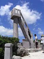 | 24°19′50″N 124°05′07″E / 24.330614°N 124.08535858°E | |
| Former Kunigami Agricultural College Entrance 旧国頭農学校玄関 kyū-Kunigami nōgakkō genkan | 1902 | Nago | relocated in 1965 | 26°35′45″N 127°57′47″E / 26.595928°N 127.96312°E | ||
| Ōmori Family Residence 大盛家住宅 Ōmori-ke jūtaku | 1915 | Taketomi | four registrations: main residence, well, stone wall, and screen wall or hinpun (ヒンプン); on Kohama Island | 24°20′21″N 123°58′40″E / 24.33908289°N 123.9779037°E | ||
| Former Tōyō Sugar Rock Phosphate Storage Facility 旧東洋製糖燐鉱石貯蔵庫 kyū-Tōyō Seitō rinkōseki chozōko | 1919 | Kitadaitō | 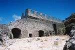 | 25°57′14″N 131°17′06″E / 25.954002°N 131.28511°E | ||
| Former Tōyō Sugar Rock Phosphate Cargo Pier 旧東洋製糖燐鉱石積荷桟橋 kyū-Tōyō Seitō rinkōseki tsumini sanbashi | 1919 | Kitadaitō | 25°57′14″N 131°17′03″E / 25.953951°N 131.284134°E | |||
| Irifukuhama Family Residence 入福浜家住宅主屋 Irifukuhama-ke jūtaku shuoku | Taishō period | Yonaguni | main residence; renovated in 2002 | 25°57′16″N 131°17′13″E / 25.95439912°N 131.28691762°E | ||
| Ryūkyū Mura 琉球村 Ryūkyū mura | end of Edo to Meiji period | Onna | seven registrations: Former Ōshiro Family Residence (旧大城家住宅) main residence (end of the Edo period), Former Higa Family Residence (旧比嘉家住宅) main residence (1877), Former Shimabukuro Family Residence (旧島袋家住宅) main residence and raised storehouse (1887), Former Tamanaha Family Residence (旧玉那覇家住宅) main residence (1891), Former Hirata Family Residence (旧平田家住宅) pigpen (1897), and Former Nishishigaki Family Residence (旧西石垣家住宅) main residence (end of Meiji period); all relocated in 1981/2 | 26°25′45″N 127°46′28″E / 26.429235°N 127.774307°E | ||
| Aragaki Family Residence 新垣家住宅 Aragaki-ke jūtaku | 1896/1956 | Naha | six registrations: screen wall, pigpen, stone wall, and east and south ponds (1896) and main residence (1956) | 26°13′48″N 127°42′42″E / 26.22994602°N 127.71163602°E | ||
| Iritakenishi Family Residence 入嵩西家住宅 Iritakenishi-ke jūtaku | late Meiji period to 1948 | Ishigaki | four registrations: well (late Meiji period), main building (1911 renovated in 1955), screen wall (1914), and stone wall (1948) | 24°21′00″N 124°09′01″E / 24.3498725°N 124.15018708°E | ||
| Ōno Drainage Tunnel 入福浜家住宅主屋 Ōno goshihai suikō | 1934 | Miyakojima | length of 640 metres (2,100 ft) | 24°48′21″N 125°19′28″E / 24.80580767°N 125.32438964°E | ||
| Former Tōyō Sugar Shimosaka Bathhouse 旧東洋製糖下阪浴場 kyū-Tōyō Seitō Shimosaka yokujō | late Taishō period | Kitadaitō | two registrations: bathhouse and water tank | 25°57′17″N 131°17′15″E / 25.95474856°N 131.28758553°E | ||
| Former Tōyō Sugar Employee Bathhouse 旧東洋製糖社員浴場 kyū-Tōyō Seitō shain yokujō | early Shōwa period | Kitadaitō | two registrations: bathhouse and water storage tank | 25°57′19″N 131°17′16″E / 25.95530611°N 131.28777294°E | ||
| Sueyoshi Family Residence 末吉家住宅 Sueyoshi-ke jūtaku | late Taishō period | Kitadaitō | two registrations: main residence and stone wall | 25°57′13″N 131°17′13″E / 25.95364259°N 131.28692356°E | ||
| Tokuyama Family Residence 渡久山家住宅 Tokuyama-ke jūtaku | 1894 to early Shōwa period | Ishigaki | four registrations: pigpen and well (1894, the well was extended at the beginning of the Shōwa period), main residence (1925), and stone wall (beginning of the Shōwa period) | 24°20′35″N 124°09′37″E / 24.34319341°N 124.16019169°E | ||
| Kubura Family Residence 久部良家住宅 Kubura-ke jūtaku | Meiji period | Yonaguni | two registrations: main residence (mid Meiji period, relocated in 1940) and stone wall (late Meiji period) | 24°28′02″N 123°00′17″E / 24.46708879°N 123.004707681762°E | ||
| Yaeyama Minzoku-en 八重山民俗園 Yaeyama Minzoku-en | 1909/23 | Ishigaki | two registrations: Former Morita Family Residence (森田家住宅) main residence (1909, relocated in 1984) and Former Makishi Family Residence (旧牧志家住宅) main residence (1923, relocated in 1980) | 24°24′18″N 124°08′43″E / 24.40504168°N 124.14523866°E | ||
| Nirokusō 弐六荘 Nirokusō | 1940 | Kitadaitō | 25°57′16″N 131°17′13″E / 25.95439912°N 131.28691762°E | |||
| Tōgei Family Residence 東迎家住宅 Tōgei-ke jūtaku | early Meiji period to 1953 | Yonaguni | five registrations: stone basin and well (early Meiji period, well renovated mid-Shōwa period); and main residence, water tank, and stone wall (1953, main residence renovated 1985) | 24°28′10″N 123°00′16″E / 24.46932551°N 123.00437733°E | ||
| Okinawa World おきなわワールド Okinawa wārudo | late Meiji period to 1934 | Nanjō | five registrations: Former Irei Family Residence (旧伊礼家住宅) main residence, Former Kyan Family Residence (旧喜屋武家住) main residence, and Former Taba Family Residence (旧田場家住宅) main residence (all late Meiji period); Former Chinen Family Residence (旧知念家住宅) pigpen (1897); and Former Uezato Family Residence (旧上里家住宅) main residence (1934); all relocated in 1995/6 | 26°08′19″N 127°45′04″E / 26.13862232°N 127.7511093°E | ||
| Yagi Family Residence 屋宜家住宅 Yagi-ke jūtaku | 1915 | Taketomi | five registrations: main residence, screen wall, and well (1952); stone wall (1952, renovated 1954), and annexe (1955) | 26°07′38″N 127°44′13″E / 26.12733247°N 127.73694047°E | ||
| Okinawa City Furusato-en 沖縄市立ふるさと園 Okinawa shiritsu Furusato-en | 1924 | Okinawa | three registrations: Former Kuba Family Residence (旧久場家住宅) main residence and screen wall and Former Hirata Family Residence (旧平田家住宅) pigpen (all relocated in 1985/6) | 26°19′41″N 127°48′15″E / 26.32792961°N 127.8042596°E | ||
| Chatan Uchinā Family Residence 北谷町うちなぁ家 主屋, ふーる Chatan-chō Uchinā-ya | Meiji period | Chatan | two registrations: main residence (1898, relocated in 2005) and pigpen (early Meiji period, relocated in 2006) | 26°19′40″N 127°46′06″E / 26.32781128°N 127.76825958°E | ||
| Former Nishinaka Sugar Cooperative Refinery Chimney 旧西中共同製糖場煙突 kyū-Nishinaka kyōdō seitō jōentotsu | 1942 | Miyakojima | height of 13 metres (43 ft) | 24°48′21″N 125°16′50″E / 24.80596944°N 125.28068888°E | ||
| Misatomura Residence 美里村屋 Misatomura-ya | 1954 | Okinawa | renovated in 1974 | 26°20′47″N 127°48′53″E / 26.34643277°N 127.81469194°E | ||
| National Treasures |    | |
|---|---|---|
| Important Cultural Properties |
| |
| Hokkaidō | ||
| Tōhoku |
| |
| Kantō |
| |
| Chūbu |
| |
| Kansai |
| |
| Chūgoku |
| |
| Shikoku | ||
| Kyūshū |
| |
| Okinawa | ||
1 | ||
| Tangible Cultural Properties | .jpg)  | |
|---|---|---|
| Intangible Cultural Properties | ||
| Folk Cultural Properties |
| |
| Monuments | ||
| Cultural Landscapes | N/A | |
| Groups of Traditional Buildings | ||
| Conservation Techniques |
| |
1 | ||
See also
- Cultural Properties of Japan
- National Treasures of Japan
- List of Historic Sites of Japan (Okinawa)
- Ryūkyū Kingdom
- Hague Convention for the Protection of Cultural Property in the Event of Armed Conflict
References
- ↑ "Pamphlet on Cultural Properties". Agency for Cultural Affairs. Retrieved 22 January 2015.
- ↑ 国宝・重要文化財 [Number of National Treasures and Important Cultural Properties by Prefecture] (in Japanese). Agency for Cultural Affairs. 1 January 2015. Retrieved 22 January 2015.
- ↑ "Database of National Cultural Properties: 国宝・重要文化財(建造物) (沖縄県)" (in Japanese). Agency for Cultural Affairs. Retrieved 22 January 2015.
- 1 2 3 4 国・県・市町村指定文化財 [National, Prefectural, and Municipal Cultural Properties] (PDF) (in Japanese). Okinawa Prefecture. 1 May 2014. Retrieved 22 January 2015.
- 1 2 3 4 5 "Gusuku Sites and Related Properties of the Kingdom of Ryukyu". UNESCO. Retrieved 22 January 2015.
- ↑ 都道府県別指定等文化財件数(都道府県分) [Number of Prefectural Cultural Properties by Prefecture] (in Japanese). Agency for Cultural Affairs. 1 May 2014. Retrieved 22 January 2015.
- ↑ 金城ダムと文化財 [Kinjo Dam and Related Cultural Properties] (in Japanese). Okinawa Prefecture. 26 December 2012. Retrieved 22 January 2015.
- ↑ 都道府県別指定等文化財件数(市町村分) [Number of Municipal Cultural Properties by Prefecture] (in Japanese). Agency for Cultural Affairs. 1 May 2014. Retrieved 22 January 2015.
- ↑ "勝連の「吉本家」全焼 うるま市指定文化財". 47NEWS(Ryūkyū Shimpō). Retrieved 5 October 2015.
- ↑ 建造物 [Structures] (in Japanese). Miyakojima City. Retrieved 22 January 2015.
- ↑ 登録文化財 [Number of Registered Cultural Properties by Prefecture] (in Japanese). Agency for Cultural Affairs. 1 May 2014. Retrieved 22 January 2015.
External links
- (Japanese) Cultural Properties in Okinawa Prefecture
- (Japanese) List of Cultural Properties in Okinawa Prefecture
This article is issued from Wikipedia - version of the 11/29/2016. The text is available under the Creative Commons Attribution/Share Alike but additional terms may apply for the media files.