List of Helsinki Metro stations

The Helsinki Metro is a metro system in Helsinki, Finland. It was opened on 2 August 1982 and remains the only metro system in Finland and the furthest north in the world. It is operated by Helsinki City Transport (HKL)[1] for Helsinki Regional Transport Authority (HSL)[2] and carries over 50 million passengers per year (58 million in 2008).[3]
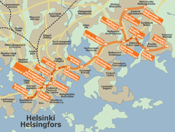
The system contains a single forked line with seventeen stations along a total length of 21.1 kilometres (13.1 mi), running from central Helsinki to the East Helsinki suburbs.[4] The six stations in central Helsinki and Puotila are located in a tunnel, the rest being on surface.[4] The Länsimetro extension will continue the line into western Helsinki and the neighbouring municipality of Espoo.[4]
Current metro line
Legend
| ||||||||||||||||||||||||||||||||||||||||||||||||||||||||||||||||||||||||||||||||||||||||||||||||||||||||||||||||||||||||||||||||||||||||||||||||||||
These are the stations on the current metro line. The names are listed first in Finnish, then in Swedish (and English, if applicable1). Bus transfers are not listed.
| Station | Opened | Transfer | Grade |
|---|---|---|---|
| Hakaniemi Hagnäs | 1982 | Tram: 1 3B 6 7A 7B 9 | Underground |
| Herttoniemi Hertonäs | 1982 | — | At-grade |
| Itäkeskus Östra centrum | 1982 | — | At-grade |
| Helsingin yliopisto Helsingfors universitet / University of Helsinki | 1995 | Tram: 1 3B 6 9 | Underground |
| Kalasatama Fiskehamnen | 2007 | — | Elevated |
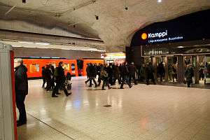
| Kamppi Kampen | 1983 | Tram: 3T | Underground |
| Kontula Gårdsbacka | 1986 | — | At-grade |
| Kulosaari Brändö | 1982 | — | At-grade |
| Mellunmäki Mellungsbacka | 1989 | — | Elevated |
| Myllypuro Kvarnbäcken | 1986 | — | At-grade |
| Puotila Botby gård | 1998 | — | Underground |
| Rautatientori Järnvägstorget / Central Railway Station | 1982 | Tram: 3B 3T 5 6 9 Commuter rail | Underground |
| Rastila Rastböle | 1998 | — | At-grade |
| Ruoholahti Gräsviken | 1993 | Tram: 8 | Underground |
| Siilitie Igelkottsvägen | 1982 | — | Elevated |
| Sörnäinen Sörnäs | 1984 | Tram: 6 7A 7B 8 | Underground |
| Vuosaari Nordsjö | 1998 | — | At-grade |
Tram lines valid between 6 June 2011 and 14 August 2011. References:[5][6]
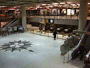
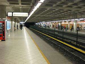
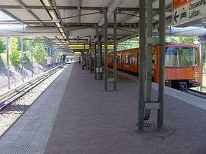
| Some stations of the Helsinki metro | ||||||||
|---|---|---|---|---|---|---|---|---|
|
Planned extensions
These are lines that are planned or under construction. Existing metro stations are shown in bold.
Länsimetro

Legend
| |||||||||||||||||||||||||||||||||||||||||||||||||||||||||||||||||||||||||||||||||
The Western Metro Extension was approved on 4 April 2007 and construction began in November 2009. The first stage will be a 13.9 km (8.6 mi) long extension from Ruoholahti to Matinkylä with seven new stations, expected to be completed by 2015.[7] The second phase will extend the line further to Kivenlahti.[8]
| † | First phase stations |
| Station | Phase | Grade |
|---|---|---|
| Espoonlahti (Esboviken) | 2 | |
| Kaitaa (Kaitans) | 2 | |
| Keilaniemi (Kägeludden)† | 1 | Underground |
| Kivenlahti (Stensvik) | 2 | |
| Koivusaari (Björkholmen)† | 1 | Underground |
| Lauttasaari (Drumsö)† | 1 | Underground |
| Matinkylä (Mattby)† | 1 | Underground |
| Niittykumpu (Ängskulla) | 2 | |
| Aalto-yliopisto (Aalto-universitet)† | 1 | Underground |
| Soukka (Sökö) | 2 | |
| Suomenoja (Finno) | 2 | |
| Tapiola (Hagalund)† | 1 | Underground |
| Urheilupuisto (Idrottsparken)† | 1 | Underground |
References:[9]
Itämetro

Legend
| ||||||||||||||||||||||||||||||||||||||||||||||||||||||||
The eastern extension is currently being planned. It would extend the metro eastwards from the current terminus at Mellunmäki.[10] Plans for the Östersundom area, including the metro extension, are expected to be complete by 2012.[11]
| Station |
|---|
| Gumböle |
| Majvik |
| Länsimäki (Västerkulla)[note 1] |
| Länsisalmi (Västersundom) |
| Salmenkallio (Sundberg) |
| Östersundom |
- ↑ The Länsimäki station has not yet been officially named.
Station names from [12]
Other proposed lines
Legend
| |||||||||||||||||||||||||||||||||||||||||||||||||||||||||||||||||||||||||||||||||||||||||||||||||||||||||||||||||||||||||||||||||||||||||||||||||||||||
Santahamina - Airport (the second metro line)
- Santahamina (Sandhamn)
- Gunillantie (Gunillavägen)
- Laajasalo (Degerö)
- Kruunuvuorenranta (Kronbergsstranden)
- Katajanokka (Skatudden)
- Kauppatori (Salutorget)
- Esplanadi (Esplanaden)
- Kamppi (Kampen)
- Töölö (Tölö)
- Olympic Stadium (Olympiastadion)
- Meilahti (Mejlans)
- Pasila (Böle)
- Olympiakylä (Olympiabyn)
- Metsälä (Krämertskog)
- Maunula (Månsas)
- Pakila (Baggböle)
- Paloheinä (Svedängen)
- Tammisto (Rosendal)
- Kartanonkoski (Herrgårdsforsen)
- Vantaanportti (Vandaport)
- Aviapolis
- Airport (Lentokenttä / Flygstation)
Pasila - Viikki (a branch of the second line)
- Pasila (Böle)
- Kumpula (Gumtäkt)
- Vanhakaupunki (Gammelstaden)
- Viikki (Vik)
Munkkivuori

A tunnel for the first metro station in Helsinki was dug in 1964 under Munkkivuori shopping center in concordance with the city's first light rail-based metro plans.[13] These would have produced of a network of over 90 kilometres (56 mi).[13][14] No metro line has ever reached this unfinished station, consisting of 0.5 km (0.31 mi) long tunnels dug in bedrock. There are no plans of connecting the station to the existing network.[13] The tunnel was flooded due to a water pipe breakage in January 2010, two months after a similar incident at the Rautatientori station.[15][16]
Notes
- ^1 The two stations on the Helsinki Metro that have an English name that is different from its Finnish name are Central Railway Station (Rautatientori) and University of Helsinki (Helsingin yliopisto).
References
- ↑ "About HKL". Helsinki City Transport. 14 April 2010. Retrieved 20 June 2011.
- ↑ "About HSL". Helsinki Regional Transport Authority. Retrieved 20 June 2011.
- ↑ Jääskeläinen, Tarja, ed. (17 November 2009). "Helsingin joukkoliikenne 2009" (PDF). Helsinki City Transport. p. 12. Retrieved 21 June 2011.
- 1 2 3 "Helsinki's metro track". Helsinki City Transport. 21 December 2009. Retrieved 21 June 2011.
- ↑ "Helsinki metro stations". Helsinki City Transport. 21 March 2011. Retrieved 20 June 2011.
- ↑ "Tram lines". Helsinki Regional Transport Authority. Retrieved 21 June 2011.
- ↑ Kairulahti, Riina (27 May 2010). "West Metro to be completed towards the end of 2015". Länsimetro Oy. Retrieved 21 June 2011.
- ↑ "Future". Länsimetro Oy. Retrieved 21 June 2011.
- ↑ "Stations". Länsimetro Oy. Retrieved 21 June 2011.
- ↑ "Metro network to be extended eastwards from Helsinki through Vantaa to Sipoo's Majvik". Helsingin Sanomat. Sanoma. 17 August 2010. Retrieved 21 June 2011.
- ↑ Jokinen, Riku (17 August 2010). "Itämetro Sipoon Majvikiin asti". Helsingin Sanomat (in Finnish). Sanoma. Retrieved 21 June 2011.
- ↑ "Picture". Helsingin Sanomat. Sanoma. 17 August 2010. Retrieved 21 June 2011.
- 1 2 3 Hannula, Tommi (17 September 2007). "Juna ei saavu koskaan ensimmäiselle metroasemalle". Helsingin Sanomat (in Finnish). Sanoma. Retrieved 22 June 2011.
- ↑ Alku, Antero (15 August 2008). "Helsingin raideliikenteen historiaa" (in Finnish). 1960-luku. Retrieved 22 June 2011.
- ↑ "Iso vesivahinko sulkee osan Munkkivuoren ostoskeskuksesta" (in Finnish). YLE Helsinki. 26 January 2010. Retrieved 22 June 2011.
- ↑ "Ripeästi vesivahinkojen torjuntaan" (in Finnish). Lassila & Tikanoja. 17 March 2010. Retrieved 22 June 2011.
External links
![]() Media related to Helsinki Metro stations at Wikimedia Commons
Media related to Helsinki Metro stations at Wikimedia Commons