List of Nevada state parks
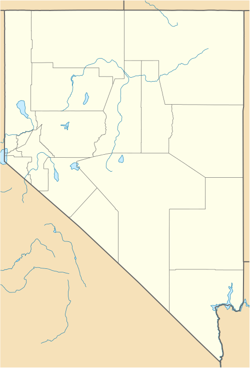
Hold cursor over locations to display park name;
click to go to park article.
This list of Nevada state parks comprises protected areas managed by the U.S. state of Nevada, which include state parks, state historic sites, and state recreation areas. There are currently 24 state park units, including Van Sickle Bi-State Park which opened in July 2011 and is operated in partnership with the state of California.[1]
The system is managed by the Nevada Division of State Parks within the Nevada Department of Conservation and Natural Resources. The Division of State Parks was created by an act of the Nevada Legislature in 1963.[2] Their mission statement reads: "The Division of State Parks plans, develops and maintains a system of parks and recreation areas for the use and enjoyment of residents and visitors. The Division also preserves areas of scenic, historic and scientific significance in Nevada."[2] The parks are grouped into a Northern Region and a Southern Region.[3]
.jpg)

List of current state parks
| Park name | Image | County or counties |
Area[4] | Elevation[5] | Year established[4] | Remarks[4] | ||
|---|---|---|---|---|---|---|---|---|
| acres | ha | ft | m | |||||
| Beaver Dam State Park | Lincoln | 2,393 | 968 | 5,348 | 1,630 | 1935 | Preserves a section of Beaver Dam Wash in eastern Nevada's most remote state park. | |
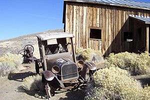
| Berlin–Ichthyosaur State Park |  | Nye | 1,540 | 620 | 6,975 | 2,126 | 1957 | Preserves several in situ ichthyosaur fossils and the ghost town of Berlin. |
| Big Bend of the Colorado State Recreation Area | Clark | | | | | 1996 | Overlooks the Colorado River within the town limits of Laughlin. | |||
| Cathedral Gorge State Park | .jpg) | Lincoln | 1,608 | 651 | 4,819 | 1,469 | 1935 | Showcases a gorge with soft bentonite walls eroded into dramatic spires. |
| Cave Lake State Park |  | White Pine | 4,160 | 1,680 | 7,198 | 2,194 | Features a 32-acre (13 ha) reservoir in the northern Schell Creek Range. | |
| Dayton State Park | Lyon | 152 | 62 | 4,360 | 1,330 | 1977 | Features a stretch of the Carson River and the site of an 1861 mill built to process silver ore from the Comstock Lode. | |
| Echo Canyon State Park |  | Lincoln | 1,080 | 440 | 5,348 | 1,630 | 1970 | Adjoins a 65-acre (26 ha) reservoir. |
| Elgin Schoolhouse State Historic Site | Lincoln | | | 3,402 | 1,037 | 2005 | Preserves a rural schoolhouse used from 1922–1967. Closed since 2008 due to unrepaired flood damage on Nevada State Route 317. | ||
| Fort Churchill State Historic Park | 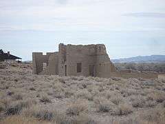 | Lyon | | | 4,255 | 1,297 | 1957 | Encompasses the ruins of a U.S. Army fort staffed 1860–1869, plus a waystation on the Pony Express and Central Overland Routes, and a corridor along the Carson River connecting to Lahontan State Recreation Area. | |
| Kershaw–Ryan State Park | Lincoln | | | 4,805 | 1,465 | 1935 | Features a verdant canyon first homesteaded in 1873. | ||
| Lahontan State Recreation Area | 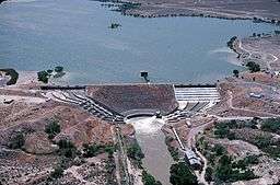 | Churchill and Lyon | | | 4,258 | 1,298 | 1971 | Surrounds Lake Lahontan, a 10,000-acre (4,000 ha) reservoir on the Carson River. | |
| Lake Tahoe – Nevada State Park | 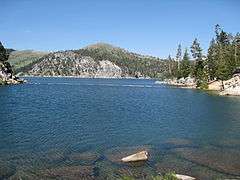 | Carson City and Washoe | 14,301 | 5,787 | 7,880 | 2,400 | 1963 | Comprises six units on the northeastern shore of Lake Tahoe and its backcountry. |
| Mormon Station State Historic Park | Douglas | 3.5 | 1.4 | 4,783 | 1,458 | 1955 | Interprets Nevada's first permanent nonnative settlement, established in 1851 on the California Trail by Mormon pioneers. | |
| Old Las Vegas Mormon Fort State Historic Park | .jpg) | Clark | | | 1,923 | 586 | 1991[6] | Interprets a partially reconstructed fort built by Mormon missionaries in 1855, the first nonnative structure in what would become Las Vegas. | |
| Rye Patch State Recreation Area |  | Pershing | | | 4,137 | 1,261 | 1971 | Adjoins the 11,000-acre (4,500 ha) Rye Patch Reservoir on the Humboldt River. | |
| South Fork State Recreation Area |  | Elko | 4,000 | 1,600 | 5,226 | 1,593 | Surrounds the 1,650-acre (670 ha) South Fork Reservoir on the South Fork Humboldt River. | |
| Spring Mountain Ranch State Park |  | Clark | 520 | 210 | 3,727 | 1,136 | 1974 | Preserves the historic Sandstone Ranch established in 1876. |
| Spring Valley State Park | Lincoln | | | 5,869 | 1,789 | 1969 | Adjoins the 65-acre (26 ha) Eagle Valley Reservoir. | ||
| Valley of Fire State Park |  | Clark | 34,880 | 14,120 | 2,464 | 751 | 1935 | Showcases red sandstone formations in Nevada's oldest and largest state park. |
| Van Sickle Bi-State Park | Douglas | 725 | 293 | 6,283 | 1,915 | 2011 | Managed by the Nevada Division of State Parks in conjunction with the California Tahoe Conservancy (formerly with California State Parks). 575 acres lie within Nevada while 150 are within El Dorado County, California. | |
| Ward Charcoal Ovens State Historic Park | 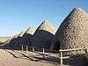 | White Pine | 160 | 65 | 7,054 | 2,150 | 1994 | Preserves six 30-foot-high (9.1 m) charcoal ovens used from 1876–1879 to produce fuel for smelting silver ore. |
| Washoe Lake State Park | .jpg) | Washoe | 8,053 | 3,259 | 5,033 | 1,534 | 1977 | Provides recreation opportunities on Washoe Lake, between Carson City and Reno. |
| Wild Horse State Recreation Area | Elko | 140 | 57 | 6,250 | 1,900 | Provides water recreation on the northeast shore of 2,830-acre (1,150 ha) Wild Horse Reservoir on the Owyhee River. | ||
Former state parks
- Floyd Lamb State Park was renamed Floyd Lamb Park at Tule Springs on July 2, 2007, when ownership was transferred to the City of Las Vegas.
- Dangberg Home Ranch Historic Park was operated by Nevada State Parks until June 30, 2011, when ownership was transferred to Douglas County.
- The former Walker Lake State Recreation Area is no longer maintained by Nevada State Parks; boat ramp users are advised "they do so at their own risk."[7]
See also
References
- ↑ "Van Sickle Bi-State Park". Sierra Nevada Geotourism MapGuide. National Geographic Society. Retrieved 2012-09-11.
- 1 2 "About". Nevada Division of State Parks. Retrieved 2012-09-11.
- ↑ "Nevada State Parks Contacts and Regional Offices". Nevada Division of State Parks. Retrieved 2012-09-11.
- 1 2 3 All data come from respective Nevada State Parks webpage unless otherwise noted.
- ↑ "Geographic Names Information System". United States Geological Survey.
- ↑ Puit, Glenn (1997-12-14). "Living History". Las Vegas Review-Journal. Las Vegas, Nev. pp. 1B.
- ↑ "Parks and Recreation". Nevada Magazine. Retrieved 2012-09-11.