List of Quaternary volcanic eruptions
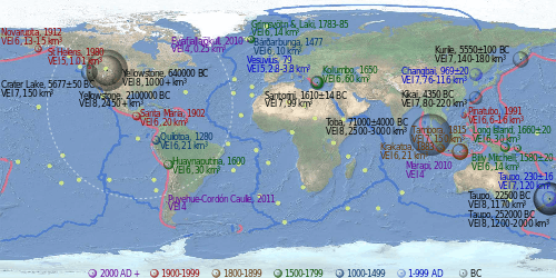
This article is a list of volcanic eruptions of approximately magnitude 6 or more on the Volcanic Explosivity Index (VEI) or equivalent sulfur dioxide emission during the Holocene, and Pleistocene eruptions of the Decade Volcanoes (Avachinsky-Koryaksky, Kamchatka; Colima, Trans-Mexican Volcanic Belt; Mount Etna, Sicily; Galeras, Andes, Northern Volcanic Zone; Mauna Loa, Hawaii; Mount Merapi, Central Java; Mount Nyiragongo, East African Rift; Mount Rainier, Washington; Sakurajima, Kagoshima Prefecture; Santamaria/ Santiaguito, Central America Volcanic Arc; Santorini, Cyclades; Taal Volcano, Luzon Volcanic Arc; Teide, Canary Islands; Ulawun, New Britain; Mount Unzen, Nagasaki Prefecture; Mount Vesuvius, Naples); Campania, Italy; South Aegean Volcanic Arc; Laguna de Bay, Luzon Volcanic Arc; Mount Pinatubo, Luzon Volcanic Arc; Toba, Sunda Arc; Mount Meager, Garibaldi Volcanic Belt; Yellowstone hotspot, Wyoming; and Taupo Volcanic Zone, greater than VEI 4.
The eruptions in the Holocene on the link: Holocene Volcanoes in Kamchatka were not added yet, but they are listed on the Peter L. Ward's supplemental table.[1] Some of the eruptions are not listed on the Global Volcanism Program timetable as well, at least not as VEI 6. The timetables of Global Volcanism Program;[2] Bristlecone pine tree-rings (Pinus longaeva, Pinus aristata, Pinus ponderosa, Pinus edulis, Pseudotsuga menziesii);[3] the 4 ka Yamal Peninsula Siberian larch (Larix sibirica) chronology;[4] the 7 ka Scots pine (Pinus sylvestris) chronology from Finnish Lapland;[5][6] GISP2 ice core;[7][8] GRIP ice core;[9] Dye 3 ice core;[9] Bipolar comparison;[10] Antarctic ice core (Bunder and Cole-Dai, 2003);[11] Antarctic ice core (Cole-Dai et al., 1997);[12] Crête ice core, in central Greenland,[13] benthic foraminifera in deep sea sediment cores (Lisiecki, Raymo 2005),[14] do not agree with each other sometimes. The 536–547 AD dust-veil event might be an impact event.[3][15]
Holocene eruptions
The Holocene epoch begins 11,700 years BP,[16] (10 000 14C years ago)
Since 2000 AD
| Name and area | Date | VEI | Products | Notes |
|---|---|---|---|---|
| Puyehue-Cordón Caulle, Southern Chile | 2011 | 5 | Largest eruption of the 21st century |
1000-2000 AD

| Name and area | Date | VEI | Products | Notes |
|---|---|---|---|---|
| Pinatubo, island of Luzon, Philippines | 1991, Jun 15 | 6 | 6 to 16 km3 (1.4 to 3.8 cu mi) of tephra | [2] an estimated 20 million tons of sulfur dioxide were emitted[17] |
| Mt. St. Helens, Washington state, USA | 1980, May 18 | 5 | 1 to 1.1 km3 (0.2 to 0.3 cu mi) of tephra | |
| Novarupta, Alaska Peninsula | 1912, Jun 6 | 6 | 13 to 15 km3 (3.1 to 3.6 cu mi) of lava[18][19][20] | |
| Santa Maria, Guatemala | 1902, Oct 24 | 6 | 20 km3 (4.8 cu mi) of tephra[21] | |
| Mount Tarawera, Taupo Volcanic Zone, New Zealand | 1886, Jun 10 | 5 | 2 km3 (0.48 cu mi) of tephra[2] | |
| Krakatoa, Indonesia | 1883, August 26–27 | 6 | 21 km3 (5.0 cu mi) of tephra[22] | |
| Mount Tambora, Lesser Sunda Islands, Indonesia | 1815, Apr 10 | 7 | 150 km3 (36 cu mi) of tephra | [2] an estimated 10-120 million tons of sulfur dioxide were emitted, produced the "Year Without a Summer"[23] |
| 1808 ice core event | Unknown eruption near equator, magnitude roughly half Tambora | Emission of sulfur dioxide around the amount of the 1815 Tambora eruption (ice cores from Antarctica and Greenland).[24] | ||
| 1808 | Major eruptions in Urzelina, Azores (Urzelina eruption, fissure vent), Klyuchevskaya Sopka, Kamchatka Peninsula,[25] and Taal Volcano, Philippines.[26] | |||
| Note: Thompson Island, northeast of Bouvet Island, South Atlantic Ocean, disappeared in the 19th century.[27] | ||||
| Grímsvötn, Northeastern Iceland | 1783–1784 | 6 | ||
| Laki | 1783–1784 | 6 | 14 cubic kilometres of lava | an estimated 120 million tons of sulfur dioxide were emitted, produced a Volcanic winter, 1783, on the North Hemisphere.[28] |
| Long Island (Papua New Guinea), northeast of New Guinea | 1660 ±20 | 6 | 30 km3 (7.2 cu mi) of tephra[2] | |
| Kolumbo, Santorini, Greece | 1650, Sep 27 | 6 | 60 km3 (14.4 cu mi) of tephra[29] | |
| Huaynaputina, Peru | 1600, Feb 19 | 6 | 30 km3 (7.2 cu mi) of tephra[30] | |
| Billy Mitchell, Bougainville Island, Papua New Guinea | 1580 ±20 | 6 | 14 km3 (3.4 cu mi) of tephra[2] | |
| Bárðarbunga, Northeastern Iceland | 1477 | 6 | 10 km3 (2.4 cu mi) of tephra[2] | |
| 1452–53 ice core event, New Hebrides arc, Vanuatu. Location is uncertain, may be Kuwae | 36 to 96 km3 (8.6 to 23.0 cu mi) of tephra | 175-700 million tons of sulfuric acid;[31][32][33] only pyroclastic flows are found at Kuwae | ||
| Mount Tarawera, Taupo Volcanic Zone, New Zealand | 1310 ±12 | 5 | 5 km3 (1.2 cu mi) of tephra (Kaharoa eruption)[2] | |
| Quilotoa, Ecuador | 1280(?) | 6 | 21 km3 (5.0 cu mi) of tephra[2] | |
| Samalas volcano, Rinjani Volcanic Complex, Lombok Island, Indonesia | 1257 | 40 km3 (dense-rock equivalent) of tephra | 1257 Samalas eruption; Arctic and Antarctic ice cores provide compelling evidence to link the ice core sulfate spike of 1258/1259 A.D. to this volcano.[34][35][36] | |
1 to 1000 AD
| Name & area | Date | VEI | Products | Notes |
|---|---|---|---|---|
| Changbai Mountains (Changbaishan), Eastern China/ North Korea border, also known as Tianchi eruption of the Baekdu Mountain | 969 AD ±20 years[37] | 7 | 76 to 116 km3 (18.2 to 27.8 cu mi) of tephra[2] | |
| Eldgjá eruption, Laki system, Iceland | 934-940 AD | 4 | Estimated 18 km3 (4.3 cu mi) of lava[38] | Estimated 219 million tons of sulfur dioxide were emitted[39] |
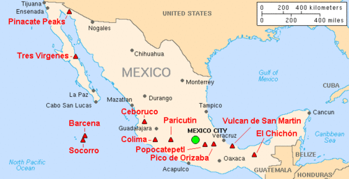
| Ceboruco, Northwest of the Trans-Mexican Volcanic Belt | 930 AD ±200 | 6 | 11 km3 (2.6 cu mi) of tephra[2] | |
| Dakataua, Northern tip of the Willaumez Peninsula, New Britain, Papua New Guinea | 800 AD ±50 | 6? | 10 km3 (2.4 cu mi)? of tephra[2] | |
| Pago, East of Kimbe, New Britain, Papua New Guinea: Witori Caldera | 710 AD ±75 | 6 | 30 km3 (7.2 cu mi) of tephra[2] | |
| Mount Churchill, eastern Alaska | 700 AD ±200 | 6 | 20 km3 (4.8 cu mi) of tephra[2] | |
| Rabaul, Rabaul Caldera, New Britain | 540 AD ±100 | 6 | 11 km3 (2.6 cu mi) of tephra[2] | |
| Ilopango, El Salvador | 450 AD ±30 | 6 | 71 km3 (17 cu mi) of tephra[2] | |
| Ksudach, Kamchatka Peninsula, Russia | 240 AD ±l00 | 6 | 20 to 26 km3 (4.8 to 6.2 cu mi) of tephra[2] | |
| Taupo Volcanic Zone, Hatepe eruption of Taupo Volcano, New Zealand | 230 AD ±16 | 7 | 120 km3 (29 cu mi) of tephra[40] | |
| Mount Vesuvius, Italy | 79 AD Oct 24 (?) | 5? | 2.8 to 3.8 km3 (0.7 to 0.9 cu mi) of tephra[2][41][42] | Pompeii eruption |
| Mount Churchill, eastern Alaska | 60 AD ±200 | 6 | 25 km3 (6.0 cu mi) of tephra[2] | |
| Ambrym, Vanuatu | 50 AD ±100 | 6 | 6 to 8 km3 (1.4 to 1.9 cu mi) of tephra[2] |
Before the Common Era (BC/BCE)
| Name & area | date | VEI | Products | Notes |
|---|---|---|---|---|
| Apoyeque, Nicaragua | 50 BC ±100 | 6 | 18 km3 (4.3 cu mi) of tephra[2] | |
| Okmok, Okmok Caldera, Aleutian Islands | 100 BC ±50 | 6 | 4 to 6 km3 (1.0 to 1.4 cu mi) of tephra[2] | |
| Raoul Island, Kermadec Islands, New Zealand | 250 BC ±75 | 6 | more than 10 km3 (2.4 cu mi) of tephra[2] | |
| Mount Meager, Garibaldi Volcanic Belt, Canada | 400 BC ±50 | 5 | ||
| Mount Tongariro, Taupo Volcanic Zone, New Zealand | 550 BC ±200 | 5 | 1.2 km3 (0.29 cu mi) of tephra[2] | |
| Pinatubo, island of Luzon, Philippines | 1050 BC ±500 | 6 | 10 to 16 km3 (2.4 to 3.8 cu mi) of tephra[2] | |
| Avachinsky, Kamchatka | 1350 BC (?) | 5 | more than 1.2 km3 (0.29 cu mi) of tephra | tephra layer IIAV3[2] |
| Pago, east of Kimbe, New Britain, Papua New Guinea: Witori Caldera | 1370 BC ±100 | 6 | 30 km3 (7.2 cu mi) of tephra[2] | |
| Taupo Volcanic Zone, Taupo, New Zealand | 1460 BC ±40 | 6 | 17 km3 (4.1 cu mi) of tephra[2] | |
| Avachinsky, Kamchatka | 1500 BC (?) | 5 | more than 3.6 km3 (0.86 cu mi) of tephra | tephra layer AV1[2] |
| Santorini (Thera), Greece, Youngest Caldera: Minoan eruption | 1610 BC ±14 years | 7 | 99 km3 (24 cu mi) of tephra [2] | Ended the Minoan settlement at Akrotiri and the Minoan age on Crete |
| Mount Aniakchak, Alaska Peninsula | 1645 BC ±10 | 6 | more than 50 km3 (12 cu mi) of tephra[2] | |
| Veniaminof, Alaska Peninsula | 1750 BC (?) | 6 | more than 50 km3 (12 cu mi) of tephra[2] | |
| Mount St. Helens, Washington, USA | 1860 BC (?) | 6 | 15 km3 (3.6 cu mi) of tephra[2] | |
| Mount Hudson, Cerro, Southern Chile | 1890 BC (?) | 6 | more than 10 km3 (2.4 cu mi) of tephra[2] | |
| Black Peak, Alaska Peninsula | 1900 BC ±150 | 6 | 10 to 50 km3 (2.4 to 12.0 cu mi) of tephra[2] | |
| Long Island (Papua New Guinea), Northeast of New Guinea | 2040 BC ± 100 | 6 | more than 11 km3 (2.6 cu mi) of tephra[2] | |
| Mount Vesuvius, Italy | 2420 BC ±40 | 5? | 3.9 km3 (0.94 cu mi) of tephra | Avellino eruption[2][41][42][43] |
| Avachinsky, Kamchatka | 3200 BC ±150 | 5 | more than 1.1 km3 (0.26 cu mi) of tephra | tephra layer IAv20 AV3[2] |
| Pinatubo, island of Luzon, Philippines | 3550 BC (?) | 6 | 10 to 16 km3 (2.4 to 3.8 cu mi) of tephra[2] | |
| Talisay (Taal) caldera (size: 15 x 20 km), island of Luzon, Philippines | 3580 BC ±200 | 6 | 50 km3 (12 cu mi) of tephra[2] | |
| Haroharo Caldera, Taupo Volcanic Zone, New Zealand | 3580 BC ±50 | 5 | 2.8 km3 (0.67 cu mi) of tephra[2] | |
| Pago, New Britain | 4000 BC ± 200 | 6? | 10 km3 (2.4 cu mi)? of tephra[2] | |
| Masaya Volcano, Nicaragua | 4050 BC (?) | 6 | more than 13 km3 (3.1 cu mi) of tephra[2] | |
| Avachinsky, Kamchatka | 4340 BC ±75 | 5 | more than 1.3 km3 (0.31 cu mi) of tephra | tephra layer IAv12 AV4[2] |
| Kikai Caldera (size: 19 km), Ryukyu Islands, Japan: Akahoya eruption | 4350 BC (?) | 7 | 80 to 220 km3 (19.2 to 52.8 cu mi) of tephra[2] | |
| Macauley Island, Kermadec Islands, New Zealand | 4360 BC ±200 | 6 | 100 km3 (24 cu mi)? of tephra[2][44] | |
| Mount Hudson, Cerro, Southern Chile | 4750 BC (?) | 6 | 18 km3 (4.3 cu mi) of tephra[2] | |
| Mount Aniakchak, Alaska Peninsula | 5250 BC ±1000 | 6 | 10 to 50 km3 (2.4 to 12.0 cu mi) of tephra[2] | |
| Mashu, Hokkaido, Japan | 5550 BC ±100 | 6 | 19 km3 (4.6 cu mi) of tephra[2] | |
| Tao-Rusyr Caldera, Kuril Islands | 5550 BC ±75 | 6 | 30 to 36 cubic kilometers (7.2 to 8.6 cu mi) of tephra[2] | |
| Mayor Island/Tuhua, Taupo Volcanic Zone, New Zealand | 5060 BC ±200 | 5 | 1.6 km3 (0.38 cu mi) of tephra[2] | |
| Crater Lake (Mount Mazama), Oregon, USA | 5677 BC ±150 | 7 | 150 km3 (36 cu mi) of tephra[2] | |
| Khangar, Kamchatka Peninsula, Russia | 5700 BC ± 16 | 6 | 14 to 16 km3 (3.4 to 3.8 cu mi) of tephra[2] | |
| Crater Lake (Mount Mazama), Oregon, USA | 5900 BC ± 50 | 6 | 8 to 28 km3 (1.9 to 6.7 cu mi) of tephra[2] | |
| Avachinsky, Kamchatka | 5980 BC ±100 | 5 | more than 8 to 10 km3 (1.9 to 2.4 cu mi) of tephra | tephra layer IAv1[2] |
| Menengai, East African Rift, Kenya | 6050 BC (?) | 6 | 70 km3 (17 cu mi)? of tephra[2] | |
| Haroharo Caldera, Taupo Volcanic Zone, New Zealand | 6060 BC ±50 | 5 | 1.2 km3 (0.29 cu mi) of tephra[2] | |
| Sakurajima, island of Kyūshū, Japan: Aira Caldera | 6200 BC ±1000 | 6 | 12 km3 (2.9 cu mi) of tephra[2] | |
| Kurile Caldera (size: 8 x 14 km), Kamchatka Peninsula, Russia | 6440 BC ± 25 years | 7 | 140 to 180 km3 (33.6 to 43.2 cu mi) of tephra | Ilinsky eruption[2] |
| Karymsky, Kamchatka Peninsula, Russia | 6600 BC (?) | 6 | 50 to 350 km3 (12.0 to 84.0 cu mi) of tephra[2] | |
| Mount Vesuvius, Italy | 6940 BC ±100 | 5? | 2.75 to 2.85 km3 (0.7 to 0.7 cu mi) of tephra | Mercato eruption[2][41][42] |
| Fisher Caldera, Unimak Island, Aleutian Islands | 7420 BC ±200 | 6 | more than 50 km3 (12 cu mi) of tephra[2] | |
| Pinatubo, island of Luzon, Philippines | 7460 BC ±150 | 6?[2] | ||
| Lvinaya Past, Kuril Islands | 7480 BC ±50 | 6 | 7 to 8 km3 (1.7 to 1.9 cu mi) of tephra[2] | |
| Rotoma Caldera, Taupo Volcanic Zone, New Zealand | 7560 BC ±18 | 5 | more than 5.6 km3 (1.3 cu mi) of tephra[2] | |
| Taupo Caldera, Taupo Volcanic Zone, New Zealand | 8130 BC ±200 | 5 | 4.7 km3 (1.1 cu mi) of tephra[2] | |
| Grímsvötn, Northeastern Iceland | 8230 BC ±50 | 6 | more than 15 km3 (3.6 cu mi) of tephra[2] | |
| Ulleung, Korea | 8750 BC (?) | 6 | more than 10 km3 (2.4 cu mi) of tephra[2] | |
| Mount Tongariro, Taupo Volcanic Zone, New Zealand | 9450 BC (?) | 5 | 1.7 km3 (0.41 cu mi) of tephra[2] | |
| Taupo Caldera, Taupo Volcanic Zone, New Zealand | 9460 BC ±200 | 5 | 1.4 km3 (0.34 cu mi) of tephra[2] | |
| Mount Tongariro, Taupo Volcanic Zone, New Zealand | 9650 BC (?) | 5 | 1.6 km3 (0.38 cu mi) of tephra[2] | |
| Nevado de Toluca, State of Mexico, Trans-Mexican Volcanic Belt | 10.5 ka | 6 | 14 km3 (3.4 cu mi) of tephra | Upper Toluca Pumice[2][45] |
| GISP2 ice core event[1] | 11.258 ka |
Pleistocene eruptions
2.588 ± 0.005 million years BP, the Quaternary period and Pleistocene epoch begin.
| Name and area | Date | VEI | Products | Notes | |
|---|---|---|---|---|---|
| GISP2 ice core event[1] | 12.657 ka | ||||
| Eifel hotspot, Laacher See, Vulkan Eifel, Germany | 12.900 ka | 6 | 6 km3 (1.4 cu mi) of tephra.[46][47][48][49] | ||
| Mount Vesuvius, Italy | 16 ka | 5 | Green Pumice[41][42] | ||
| Mount Vesuvius, Italy | 18.3 ka | 6 | Basal Pumice[41][42] | ||
| Santorini (Thera), Greece: Cape Riva Caldera | about 21 ka[2] | ||||
| Aira Caldera, south of the island of Kyūshū, Japan | about 22 ka | 7 | more than 400 km3 (96.0 cu mi) of tephra.[50] | ||
| Taupo Volcanic Zone, Oruanui eruption, Taupo volcano, New Zealand | around 24.5 ka | 8 | Approximately 1,170 km3 (280.7 cu mi) of tephra[51][52][53][54] | ||
| Laguna Caldera (size: 10 x 20 km), South-East of Manila, island of Luzon | 27-29 ka[2] | ||||
| Campi Flegrei, Naples, Italy | 39.280 ka ± 0.11 | [55] 200 cubic kilometres of lava | Campanian Tuff [1] | ||
| Galeras, Andes, Northern Volcanic Zone, Colombian department of Nariño | 40 ka | 2 km3 (0.5 cu mi) of tephra | |||
| Taupo Volcanic Zone, Rotoiti Ignimbrite, North Island, New Zealand | about 50 ka | 7 | about 240 km3 (57.6 cu mi) of tephra.[56] | ||
| Santorini (Thera), Greece: Skaros Caldera | about 70 ka[2] | ||||
| Lake Toba (size: 100 x 30 km), Sumatra, Indonesia | 73 ka ±4 | 2,500 to 3,000 km3 (599.8 to 719.7 cu mi) of tephra | probably 6,000 million tons of sulfur dioxide were emitted (Youngest Toba Tuff).[17][57][58][59][60] | ||
| Yellowstone hotspot: Yellowstone Caldera | between 70 and 150 ka | 1,000 km3 (239.9 cu mi) intracaldera rhyolitic lava flows.[2] | |||
| Galeras, Andes, Northern Volcanic Zone, Colombian department of Nariño | 150 ka | 2 km3 (0.5 cu mi) of tephra | |||
| Kos-Nisyros Caldera, Greece | 161 ka | 110 km3 (26 cu mi) | Kos Plateau Tuff.[1] | ||
| Taal Caldera, island of Luzon, Philippines | between 500 and 100 ka | 25–30 km caldera formed by four explosive eruptions | |||
| Santorini (Thera), Greece: Southern Caldera | about 180 ka[2] | ||||
| Taupo Volcanic Zone, Rotorua Caldera (size: 22 km wide), New Zealand | 220 ka | more than 340 km3 (81.6 cu mi) of tephra.[1] | |||
| Taupo Volcanic Zone, Maroa Caldera (size: 16 x 25 km), New Zealand | 230 ka | 140 km3 (33.6 cu mi) of tephra.[1] | |||
| Taupo Volcanic Zone, Reporoa Caldera (size: 10 x 15 km), New Zealand | 230 ka | 7 | around 100 km3 (24.0 cu mi) of tephra[2] | ||
| Taupo Volcanic Zone, Whakamaru Caldera (size: 30 x 40 km), North Island, New Zealand | around 254 ka | 8 | 1,200 to 2,000 km3 (288 to 480 cu mi) of tephra | Whakamaru Ignimbrite/Mount Curl Tephra[61][62] | |
| Taupo Volcanic Zone, Matahina Ignimbrite, Haroharo Caldera, North Island, New Zealand | 280 ka | 7 | about 120 km3 (28.8 cu mi) of tephra.[63] | ||
| Sabatini volcanic complex, Sabatini, Italy | 374 ka | more than 200 km3 (48 cu mi) | Morphi tephra.[1] | ||
| Roccamonfina Caldera (size: 65 x 55 km), Roccamonfina, Italy | 385 ka | 100 to 125 km3 (24.0 to 30.0 cu mi) of tephra.[1] | |||
| Lake Toba, Sumatra, Indonesia | 501 ka ±5 | Middle Toba Tuff[59] | |||
| Galeras, Andes, Northern Volcanic Zone, Colombian department of Nariño | 560 ka | 15 km3 (3.6 cu mi) of tephra | |||
| Yellowstone hotspot: Yellowstone Caldera (size: 45 x 85 km) | 640 ka | 8 | more than 1,000 km3 (240 cu mi) of tephra | Lava Creek Tuff[2] | |
| Lake Toba, Sumatra, Indonesia | 840 ka ±30 | Oldest Toba Tuff[59] | |||
| Taupo Volcanic Zone, Mangakino Caldera, North Island, New Zealand | 0.97 Ma | more than 300 km3 (72.0 cu mi) | Rocky Hill Ignimbrite[1] | ||
| Taupo Volcanic Zone, Mangakino Caldera, North Island, New Zealand | 1.01 Ma | more than 300 km3 (72.0 cu mi) | Unit E[1] | ||
| Lake Toba, Sumatra, Indonesia | 1.2 ±0.16 Ma | Haranggoal Dacite Tuff[59] | |||
| Taupo Volcanic Zone, Mangakino Caldera, North Island, New Zealand | 1.23 Ma | more than 300 km3 (72.0 cu mi) | Ongatit Ignimbrite[1][64] | ||
| Yellowstone hotspot: Henry's Fork Caldera (size: 16 km wide) | 1.3 Ma | 7 | 280 km3 (67.2 cu mi) | Mesa Falls Tuff.[2] | |
| Yellowstone hotspot: Island Park Caldera (size: 100 x 50 km) | 2.1 Ma | 8 | 2,450 km3 (588 cu mi) | Huckleberry Ridge Tuff.[1][2] |
Notes

- Iceland has four volcanic zones: Reykjanes (Mid-Atlantic Ridge),[65] West and North Volcanic Zones (RVZ, WVZ, NVZ) and the East Volcanic Zone (EVZ). The Mid-Iceland Belt (MIB) connects them across central Iceland. There are two intraplate belts too (Öræfajökull (ÖVB) and Snæfellsnes (SVB)).
- Iceland's East Volcanic Zone: the central volcanoes of Vonarskard and Hágöngur belong to the same volcanic system; this also applies to Bárðarbunga and Hamarinn, and Grímsvötn and Þórðarhyrna.[66][67][68]
- Laki is part of a volcanic system, centering on the Grímsvötn volcano (Long NE-SW-trending fissure systems, including Laki, extend from the central volcano).[2]
- The Eldgjá canyon and the Katla volcano form another volcanic system. Although the Eldgjá canyon and the Laki fissure are very near from each other, lava from the Katla and the Hekla volcanic systems result in transitional alkalic basalts and lava from the central volcanoes result in tholeiitic basalts.
- The central volcano of Bárðarbunga, the Veidivötn and Trollagigar fissures form one volcanic system, which extend about 100 km SW to near Torfajökull volcano and 50 km NE to near Askja volcano, respectively. The subglacial Loki-Fögrufjöll volcanic system located SW of Bárðarbunga volcano is also part of the Bárðarbunga volcanic system and contains two subglacial ridges extending from the largely subglacial Hamarinn central volcano (15 km southwest of Bárðarbunga); the Loki ridge trends to the NE and the Fögrufjöll ridge to the SW.[2]
- Iceland's East Volcanic Zone: the central volcanoes of Vonarskard and Hágöngur belong to the same volcanic system; this also applies to Bárðarbunga and Hamarinn, and Grímsvötn and Þórðarhyrna.[66][67][68]
- New Zealand, North Island, Taupo Volcanic Zone:
- The following Volcanic Centers belong to the Taupo Volcanic Zone: Rotorua, Okataina, Maroa, Taupo, Tongariro and Mangakino.[69] It includes Mangakino volcano, Reporoa Caldera, Mount Tarawera, Mount Ruapehu, Mount Tongariro and White Island. The Taupo Volcanic Zone forms a southern portion of the active Lau-Havre-Taupo back-arc basin, which lies behind the Kermadec-Tonga subduction zone (Hikurangi Trough - Kermadec Trench - Tonga Trench).[70] Some lakes in the area: Taupo, Rotorua, Rotomahana, and Rerewhakaaitu. Lake Okataina, Lake Tarawera, Lake Rotokakahi (Green Lake), Lake Tikitapu (Blue Lake), Lake Okareka, and Lake Rotoiti lie within the Okataina Caldera.
- Taupo Volcanic Zone, the Mangakino Volcanic Center is the westernmost and oldest rhyolitic caldera volcano in the Taupo Volcanic Zone. Mangakino is a town too.[71]
- Taupo Volcanic Zone, Maroa Volcanic Center. The Maroa Caldera formed in the Northeast corner of the Whakamaru Caldera. The Whakamaru Caldera partially overlaps with the Taupo Caldera on the South. The Orakeikorako, Ngatamariki, Rotokaua, and Wairakei hydrothermal areas are located within or adjacent to the Whakamaru caldera. Whakamaru is a town too.[2]
- The oldest volcanic zone in the North Island is the Northland Region, then the Coromandel Volcanic Zone (CVZ), then the Mangakino caldera complex and the Kapenga Caldera and then the rest of the Taupo Volcanic Zone (TVZ).
- Santorini, South Aegean Volcanic Arc. The southern Aegean is one of the most rapidly deforming regions of the Himalayan-Alpine mountain belt (Alpide belt).[72]
- The twin volcanoes of Nindirí and Masaya lie within the massive Pleistocene Las Sierras pyroclastic shield volcano.[2]
- There are two peaks in the Colima volcano complex: Nevado de Colima (4,330 m), which is older and inactive, lies 5 km north of the younger and very active 3,860 m Volcán de Colima (also called Volcán de Fuego de Colima).
- The largely submarine Kuwae Caldera cuts the flank of the Late Pleistocene or Holocene Tavani Ruru volcano, the submarine volcano Karua lies near the northern rim of Kuwae Caldera.[2]
- Bismarck volcanic arc, the Rabaul Caldera includes the sub-vent of Tavurvur and the sub-vent of Vulcan.
- Bismarck volcanic arc, Pago volcano, New Britain, Papua New Guinea, is a young post-caldera cone within the Witori Caldera. The Buru Caldera cuts the SW flank of the Witori volcano.[2]
- Sakurajima, Kyūshū, Japan, is a volcano of the Aira Caldera.
- The Mount Unzen volcanic complex, East of Nagasaki, Japan, comprises three large stratovolcanoes with complex structures, Kinugasa on the North, Fugen-dake at the East-center, and Kusenbu on the South.
Nomenclature
Each state/ country seem to have a slightly different approach, but there is an order:
- Craton, and then Province as sections or regions of a craton.
- First: volcanic arc, volcanic belt and volcanic zone.
- Second: volcanic area, caldera cluster and caldera complex.
- Third: volcanic field, volcanic system and volcanic center.
- A volcanic field is a localized area of the Earth's crust that is prone to localized volcanic activity.
- A volcanic group (aka a volcanic complex) is a collection of related volcanoes or volcanic landforms.
- Neutral: volcanic cluster and volcanic locus.
In the Basin and Range Province the volcanic fields are nested. The McDermit volcanic field, is also named Orevada rift volcanic field. The Latir-Questa volcanic locus and the Taos Plateau volcanic field seem to be in a similar area. The Southwest Nevada volcanic field, the Crater Flat-Lunar Crater volcanic zone, the Central Nevada volcanic field, the Indian Peak volcanic field and the Marysvale volcanic field seem to have no transition between each other; the Ocate volcanic field is also known as the Mora volcanic field; and the Red Hill volcanic field is also known as Quemado volcanic field.
References
- 1 2 3 4 5 6 7 8 9 10 11 12 13 "Supplementary Table to P.L. Ward, Thin Solid Films (2009) Major volcanic eruptions and provinces" (PDF). Teton Tectonics. Retrieved 2010-03-16.
- 1 2 3 4 5 6 7 8 9 10 11 12 13 14 15 16 17 18 19 20 21 22 23 24 25 26 27 28 29 30 31 32 33 34 35 36 37 38 39 40 41 42 43 44 45 46 47 48 49 50 51 52 53 54 55 56 57 58 59 60 61 62 63 64 65 66 67 68 69 70 71 72 73 74 75 76 77 78 79 80 81 82 83 84 85 86 87 http://www.volcano.si.edu/world/largeeruptions.cfm Large Holocene Eruptions Archived February 13, 2010, at the Wayback Machine.
- 1 2 Salzer, Matthew W.; Malcolm K. Hughes (2007). "Bristlecone pine tree rings and volcanic eruptions over the last 5000 yr" (PDF). Quaternary Research. 67: 57–68. Bibcode:2007QuRes..67...57S. doi:10.1016/j.yqres.2006.07.004. Retrieved 2010-03-18.
- ↑ Hantemirov, Rashit M.; Shiyatov, Stepan G. (2002). "A continuous multimillennial ring-width chronology in Yamal, northwestern Siberia". The Holocene. 12 (6): 717–726. doi:10.1191/0959683602hl585rp.
- ↑ Eronen, Matti; Pentti Zetterberg; Keith R. Briffa; Markus Lindholm; Jouko Meriläinen; Mauri Timonen (2002). "The supra-long Scots pine tree-ring record for Finnish Lapland: Part 1, chronology construction and initial inferences". The Holocene. 12 (6): 673–680. doi:10.1191/0959683602hl580rp.
- ↑ Helama, Samuli; Markus Lindholm; Mauri Timonen; Jouko Meriläinen; Matti Eronen (2002). "The supra-long Scots pine tree-ring record for Finnish Lapland: Part 2, interannual to centennial variability in summer temperatures for 7500 years". The Holocene. 12 (6): 681–7. doi:10.1191/0959683602hl581rp.
- ↑ Zielinski, Gregory A.; Mayewski, P.A.; Meeker, L.D.; Whitlow, S.; Twickler, M.S.; Morrison, M.; Meese, D.A.; Gow, A.J.; Alley, R.B. (13 May 1994). "Record of volcanism since 7000 B.C. from the GISP2 Greenland ice core and implications for the volcano–climate system". Science. 264 (5161): 948–952. Bibcode:1994Sci...264..948Z. doi:10.1126/science.264.5161.948. PMID 17830082.
- ↑ Zielinski, Gregory A. (1995). "Stratospheric loading and optical depth estimates of explosive volcanism over the last 2100 years derived from the Greenland Ice Sheet Project 2 ice core". Journal of Geophysical Research. 100 (D10): 20937–20955. Bibcode:1995JGR...10020937Z. doi:10.1029/95JD01751. Retrieved 2010-03-19.
- 1 2 Clausen, H.B.; Hammer, C.U.; Hvidberg, C.S.; Dahl-Jensen, D.; Steffensen, J.P.; Kipfstuhl, J.; Legrand, M. (1997). "A comparison of volcanic records over the past 4000 years from the Greenland Ice Core Project and Dye 3 Greenland ice cores.". Journal of Geophysical Research. 102 (C12): 26707–23. Bibcode:1997JGR...10226707C. doi:10.1029/97JC00587. Retrieved 2010-03-19.
- ↑ Langway, C.C.; Osada, K.; Clausen, H.B.; Hammer, C.U.; Shoji, H. (1995). "A 10-century comparison of prominent bipolar volcanic events in ice cores.". Journal of Geophysical Research. 100 (D8): 16241–16247. Bibcode:1995JGR...10016241L. doi:10.1029/95JD01175. Retrieved 2010-03-19.
- ↑ Budner, Drew and Cole-Dai, Jihong (2003). "The number and magnitude of explosive volcanic eruptions between 904 and 1865 A.D.: Quantitative evidence from a new South Pole ice core" (PDF). In Robock, A. and Oppenheimer, C. Volcanism and the Earth's Atmosphere. Geophysical Monograph Series. 139. American Geophysical Union. pp. 165–176. doi:10.1029/139GM10. ISBN 0-87590-998-1.
The number and magnitude of large explosive volcanic eruptions between 904 and 1865 A.D.: Quantitative evidence from a new South Pole ice core
- ↑ Cole-Dai, J.; Mosley-Thompson, E.; Thompson, L.G. (1997). "Annually resolved southern hemisphere volcanic history from two Antarctic ice cores" (PDF). Journal of Geophysical Research. 102: 16761–71. Bibcode:1997JGR...10216761C. doi:10.1029/97JD01394. Retrieved 2010-03-19.
- ↑ Crowley, Thomas J.; Criste, Tamara A.; Smith, Neil R. (1993). "Reassessment of Crete (Greenland) ice core acidity/volcanism link to climate change". Geophysical Research Letters. 20 (3): 209–212. Bibcode:1993GeoRL..20..209C. doi:10.1029/93GL00207. Retrieved 2010-03-19.
- ↑ Lisiecki, L. E.; Raymo, M. E. (January 2005). "A Pliocene-Pleistocene stack of 57 globally distributed benthic δ18O records" (PDF). Paleoceanography. 20: PA1003. Bibcode:2005PalOc..20.1003L. doi:10.1029/2004PA001071.
Lisiecki, L. E.; Raymo, M. E. (May 2005). "Correction to "A Pliocene-Pleistocene stack of 57 globally distributed benthic δ18O records"". Paleoceanography. 20 (2): PA2007. Bibcode:2005PalOc..20.2007L. doi:10.1029/2005PA001164.
data: doi:10.1594/PANGAEA.704257. - ↑ Baillie, M.G.L. (1994). "Dendrochronology raises questions about the nature of the AD 536 dust-veil event". The Holocene. 4 (2): 212–7. doi:10.1177/095968369400400211.
- ↑ "International Stratigraphic Chart" (PDF). International Commission on Stratigraphy. Retrieved 2009-12-23.
- 1 2 Robock, A., C.M. Ammann, L. Oman, D. Shindell, S. Levis, and G. Stenchikov (2009). "Did the Toba volcanic eruption of ~74k BP produce widespread glaciation?". Journal of Geophysical Research. 114: D10107. Bibcode:2009JGRD..11410107R. doi:10.1029/2008JD011652.
- ↑ Brantley, Steven R. (1999-01-04). Volcanoes of the United States. Online Version 1.1. United States Geological Survey. p. 30. ISBN 0-16-045054-3. OCLC 156941033. Retrieved 2008-09-12.
- ↑ Judy Fierstein; Wes Hildreth; James W. Hendley II; Peter H. Stauffer (1998). "Can Another Great Volcanic Eruption Happen in Alaska? - U.S. Geological Survey Fact Sheet 075-98". Version 1.0. United States Geological Survey. Retrieved 2008-09-10.
- ↑ Fierstein, Judy; Wes Hildreth (2004-12-11). "The plinian eruptions of 1912 at Novarupta, Katmai National Park, Alaska". Bulletin of Volcanology. Springer. 54 (8): 646. Bibcode:1992BVol...54..646F. doi:10.1007/BF00430778.
- ↑ "Santa Maria". Global Volcanism Program. Smithsonian Institution. Retrieved 2010-03-19.
- ↑ Hopkinson, Deborah (Jan 2004). "The Volcano That Shook the world: Krakatoa 1883". Scholastic.com. New York: Storyworks. 11 (4): 8.
- ↑ Oppenheimer, Clive (2003). "Climatic, environmental and human consequences of the largest known historic eruption: Tambora volcano (Indonesia) 1815". Progress in Physical Geography. 27 (2): 230–259. doi:10.1191/0309133303pp379ra.
- ↑ Dai, Jihong; Mosley-Thompson, Ellen; Thompson, Lonnie G. (1991). "Ice core evidence for an explosive tropical volcanic eruption six years preceding Tambora". Journal of Geophysical Research: Atmospheres. 96 (D9): 17, 361–17,366. doi:10.1029/91jd01634.
- ↑ http://www.kscnet.ru/ivs/kvert/volcanoes/Klyuchevskoy/index_eng.html
- ↑ http://www.iml.rwth-aachen.de/Petrographie/taal-mas/ta-maso.htm
- ↑ Baker, P. E. (1967). "Historical and geological notes on Bouvetoya" (PDF). British Antarctic Survey Bulletin. 13: 71–84. Retrieved 17 June 2010.
Abstract: it is suggested that "Thompson Island",... may have disappeared as a result of a volcanic eruption during the nineteenth century.
- ↑ BBC Timewatch: "Killer Cloud", broadcast 19 January 2007
- ↑ Haraldur Sigurdsson; S. Carey; C. Mandeville (1990). Assessment of mass, dynamics and environmental effects of the Minoan eruption of the Santorini volcano. Thera and the Aegean World III: Proceedings of the Third Thera Conference. II. pp. 100–12.
- ↑ "Huaynaputina". Global Volcanism Program. Smithsonian Institution. Retrieved 2008-12-29.
- ↑ Nemeth, Karoly; Shane J. Cronin; James D.L. White (2007). "Kuwae caldera and climate confusion". The Open Geology Journal. 1 (5): 7–11. Bibcode:2007OGJ.....1....7N. doi:10.2174/1874262900701010007.
- ↑ Gao, Chaochao; Robock, A.; Self, S.; Witter, J. B.; Steffenson, J. P.; Clausen, H. B.; Siggaard-Andersen, M.-L.; Johnsen, S.; Mayewski, P. A.; Ammann, C. (27 June 2006). "The 1452 or 1453 A.D. Kuwae eruption signal derived from multiple ice core records: Greatest volcanic sulfate event of the past 700 years". Journal of Geophysical Research. 111: D12107. Bibcode:2006JGRD..11112107G. doi:10.1029/2005JD006710. Retrieved 2010-03-19.
- ↑ Witter, J.B.; Self S. (January 2007). "The Kuwae (Vanuatu) eruption of AD 1452: potential magnitude and volatile release". Bulletin of Volcanology. 69 (3): 301–318. Bibcode:2007BVol...69..301W. doi:10.1007/s00445-006-0075-4.
- ↑ Lavigne, Franck (4 September 2013). "Source of the great A.D. 1257 mystery eruption unveiled, Samalas volcano, Rinjani Volcanic Complex, Indonesia". Proceedings of the National Academy of Sciences of the United States of America. Retrieved 1 October 2013.
- ↑ "Mystery 13th Century eruption traced to Lombok, Indonesia". BBC News. 30 September 2013. Retrieved 1 October 2013.
- ↑ Oppenheimer, Clive (19 Mar 2003). "Ice core and palaeoclimatic evidence for the timing and nature of the great mid-13th century volcanic eruption". International Journal of Climatology. Royal Meteorological Society. 23 (4): 417–426. Bibcode:2003IJCli..23..417O. doi:10.1002/joc.891.
- ↑ Horn, Susanne; Schmincke, Hans-Ulrich (2000). "Volatile emission during the eruption of Baitoushan Volcano (China/North Korea) ca. 969 AD". Bulletin of Volcanology. 61 (8): 537–555. doi:10.1007/s004450050004.
- ↑ "Katla: Eruptive History". Global Volcanism Program. Smithsonian Institution.
- ↑ "Laki and Eldgjá—two good reasons to live in Hawai`". USGS - Hawaiian Volcano Observatory. 26 November 2008. Retrieved 2009-08-06.
- ↑ "Taupo - Eruptive History". Global Volcanism Program. Smithsonian Institution. Retrieved 2008-03-16.
- 1 2 3 4 5 "Summary of the eruptive history of Mt. Vesuvius". Osservatorio Vesuviano, Italian National Institute of Geophysics and Volcanology. Archived from the original on December 3, 2006. Retrieved 2006-12-08.
- 1 2 3 4 5 "Somma-Vesuvius". Department of Physics, University of Rome. Retrieved 2006-12-08.
- ↑ "An ancient Bronze Age village (3500 bp) destroyed by the pumice eruption in Avellino (Nola-Campania)". Retrieved 2006-12-08.
- ↑ Latter, J. H.|| Lloyd, E. F.|| Smith, I. E. M.|| Nathan, S. (1992). Volcanic hazards in the Kermadec Islands and at submarine volcanoes between southern Tonga and New Zealand, Volcanic hazards information series 4. Wellington, New Zealand. Ministry of Civil Defence. 44 p.
- ↑ Arce, J. L.; Macías, J. L.; Vázquez-Selem, L. (2003). "The 10.5 ka Plinian eruption of Nevado de Toluca volcano, Mexico: Stratigraphy and hazard implications". Geological Society of America Bulletin. 115 (2): 230–248. Bibcode:2003GSAB..115..230A. doi:10.1130/0016-7606(2003)115<0230:TKPEON>2.0.CO;2. ISSN 0016-7606.
- ↑ van den Bogaard, P (1995). "40Ar/(39Ar) ages of sanidine phenocrysts from Laacher See Tephra (12,900 yr BP): Chronostratigraphic and petrological significance". Earth and Planetary Science Letters. 133 (1–2): 163–174. Bibcode:1995E&PSL.133..163V. doi:10.1016/0012-821X(95)00066-L.
- ↑ P de Klerk, W Janke, P Kühn and M Theuerkauf (December 2008). "Environmental impact of the Laacher See eruption at a large distance from the volcano: Integrated palaeoecological studies from Vorpommern (NE Germany)". Palaeogeography, Palaeoclimatology, Palaeoecology. 270 (1–2): 196–214. doi:10.1016/j.palaeo.2008.09.013.
- ↑ Baales, Michael; Jöris, Olaf; Street, Martin; Bittmann, Felix; Weninger, Bernhard; Wiethold, Julian (November 2002). "Impact of the Late Glacial Eruption of the Laacher See Volcano, Central Rhineland, Germany". Quaternary Research. 58 (3): 273–288. Bibcode:2002QuRes..58..273B. doi:10.1006/qres.2002.2379.
- ↑ Forscher warnen vor Vulkan-Gefahr in der Eifel. Spiegel Online, 13. Februar 2007. Retrieved January 11, 2008
- ↑ Aramaki, Shigeo (1984). "Formation of the Aira Caldera, Southern Kyushu, ∼22,000 Years Ago". Journal of Geophysical Research. 89 (B10): 8485–8501. Bibcode:1984JGR....89.8485A. doi:10.1029/JB089iB10p08485.
- ↑ Wilson, Colin J. N. (2001). "The 26.5 ka Oruanui eruption, New Zealand: an introduction and overview". Journal of Volcanology and Geothermal Research. 112: 133–174. Bibcode:2001JVGR..112..133W. doi:10.1016/S0377-0273(01)00239-6.
- ↑ Manville, Vern & Wilson, Colin J. N. (2004). "The 26.5 ka Oruanui eruption, New Zealand: a review of the roles of volcanism and climate in the post-eruptive sedimentary response". New Zealand Journal of Geology & Geophysics. 47 (3): 525–547. doi:10.1080/00288306.2004.9515074.
- ↑ Wilson CJ, Blake S, Charlier BL, Sutton AN (2006). "The 26.5 ka Oruanui Eruption, Taupo Volcano, New Zealand: Development, Characteristics and Evacuation of a Large Rhyolitic Magma Body". Journal of Petrology. 47 (1): 35–69. doi:10.1093/petrology/egi066.
- ↑ Richard Smith, David J. Lowe and Ian Wright. 'Volcanoes - Lake Taupo', Te Ara - the Encyclopedia of New Zealand, updated 16-Apr-2007
- ↑ De Vivo, B.; Rolandi, G.; Gans, P. B.; Calvert, A.; Bohrson, W. A.; Spera, F. J.; Belkin, H. E. (November 2001). "New constraints on the pyroclastic eruptive history of the Campanian volcanic Plain (Italy)". Mineralogy and Petrology. Springer Wien. 73 (1–3): 47–65. Bibcode:2001MinPe..73...47D. doi:10.1007/s007100170010. Retrieved 2008-09-20.
- ↑ Froggatt, P. C. & Lowe, D. J. (1990). "A review of late Quaternary silicic and some other tephra formations from New Zealand: their stratigraphy, nomenclature, distribution, volume, and age". New Zealand Journal of Geology and Geophysics. 33: 89–109. doi:10.1080/00288306.1990.10427576.
- ↑ Twickler and K. Taylor, G. A.; Mayewski, P. A.; Meeker, L. D.; Whitlow, S.; Twickler, M. S.; Taylor, K. (1996). "Potential Atmospheric impact of the Toba mega-eruption ~71'000 years ago". Geophysical Research Letters. American Geophysical Union. 23 (8): 837–840. Bibcode:1996GeoRL..23..837Z. doi:10.1029/96GL00706.
- ↑ Jones, S.C. (2007) The Toba supervolcanic eruption: Tephra-fall deposits in India and Paleoanthropological implications|| in The evolution and history of human populations in South Asia (eds.) M D Petraglia and B Allchin (New York: Springer Press) pp 173-200
- 1 2 3 4 Chesner, C.A.; Westgate, J.A.; Rose, W.I.; Drake, R.; Deino, A. (March 1991). "Eruptive History of Earth's Largest Quaternary caldera (Toba, Indonesia) Clarified" (PDF). Geology. 19 (3): 200–203. Bibcode:1991Geo....19..200C. doi:10.1130/0091-7613(1991)019<0200:EHOESL>2.3.CO;2. Retrieved 2010-01-20.
- ↑ Ninkovich, D.; Shackleton, N.J.; Abdel-Monem, A.A.; Obradovich, J.D.; Izett, G. (7 December 1978). "K−Ar age of the late Pleistocene eruption of Toba, north Sumatra". Nature. Nature Publishing Group. 276 (276): 574–577. Bibcode:1978Natur.276..574N. doi:10.1038/276574a0.
- ↑ Froggatt, P. C.; Nelson, C. S.; Carter, L.; Griggs, G.; Black, K. P. (13 February 1986). "An exceptionally large late Quaternary eruption from New Zealand". Nature. 319 (6054): 578–582. Bibcode:1986Natur.319..578F. doi:10.1038/319578a0.
The minimum total volume of tephra is 1,200 km³ but probably nearer 2,000 km³, ...
. - ↑ Bryan, Scott E.; Teal R. Riley; Dougal A. Jerram; Christopher J. Stephens; Philip T. Leat (2002). "Silicic volcanism: An undervalued component of large igneous provinces and volcanic rifted margins" (PDF). Geological Society of America (Special Paper 362). Retrieved 2010-03-23.
- ↑ Bailet, R. A. & Carr, R. G. (1994). "Physical geology and eruptive history of the Matahina Ignimbrite, Taupo Volcanic Zone, North Island, New Zealand". New Zealand Journal of Geology and Geophysics. 37 (3): 319–344. doi:10.1080/00288306.1994.9514624.
- ↑ Briggs, R.M.; Gifford, M.G.; Moyle, A.R.; Taylor, S.R.; Normaff, M.D.; Houghton, B.F.; Wilson, C.J.N. (1993). "Geochemical zoning and eruptive mixing in ignimbrites from Mangakino volcano, Taupo Volcanic Zone, New Zealand". Journal of Volcanology and Geothermal Research. 56 (3): 175–203. Bibcode:1993JVGR...56..175B. doi:10.1016/0377-0273(93)90016-K..
- ↑ "Reykjanes". Global Volcanism Program. Retrieved 2010-04-20.
- ↑ Gudmundsson, Magnús T.; Thórdís Högnadóttir (January 2007). "Volcanic systems and calderas in the Vatnajökull region, central Iceland: Constraints on crustal structure from gravity data". Journal of Geodynamics. 43 (1): 153–169. Bibcode:2007JGeo...43..153G. doi:10.1016/j.jog.2006.09.015.
- ↑ T. Thordarson & G. Larsen (January 2007). "Volcanism in Iceland in historical time: Volcano types, eruption styles and eruptive history". Journal of Geodynamics. 43 (1): 118–152. Bibcode:2007JGeo...43..118T. doi:10.1016/j.jog.2006.09.005.
- ↑ "Surtsey Nomination Report 2007" (PDF). Surtsey, Island. Retrieved 2010-03-30.
- ↑ Cole, J.W. (1990). "Structural control and origin of volcanism in the Taupo volcanic zone, New Zealand". Bulletin of Volcanology. 52 (6): 445–459. Bibcode:1990BVol...52..445C. doi:10.1007/BF00268925.
- ↑ L. M. Parson & I. C. Wright (1996). "The Lau-Havre-Taupo back-arc basin: A southward-propagating, multi-stage evolution from rifting to spreading". Tectonophysics. 263: 1–22. Bibcode:1996Tectp.263....1P. doi:10.1016/S0040-1951(96)00029-7.
- ↑ Krippner, Stephen J. P., Briggs, Roger M., Wilson, Colin J. N., Cole, James W. (1998). "Petrography and geochemistry of lithic fragments in ignimbrites from the Mangakino Volcanic Centre: implications for the composition of the subvolcanic crust in western Taupo Volcanic Zone, New Zealand". New Zealand Journal of Geology and Geophysics. 41 (2): 187–199. doi:10.1080/00288306.1998.9514803.
- ↑ The South Aegean Active Volcanic Arc: Present Knowledge and Future Perspectives By Michaēl Phytikas, Georges E. Vougioukalakis, 2005, Elsevier, 398 pages, ISBN 0-444-52046-5