List of earthquakes in New Zealand
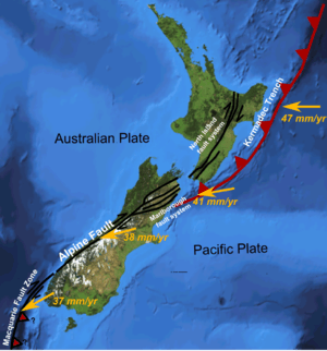
Major
active fault zones of New Zealand showing variation in displacement vector of
Pacific Plate relative to
Australian Plate along the boundary (left) and the distribution of earthquakes (magnitude 5 or greater)
This is a list of large earthquakes that have occurred in New Zealand. Only earthquakes with a magnitude of 6.0 or greater are listed, except for a few that had a moderate impact. Aftershocks are not included, unless they were of great significance or contributed to a death toll, such as the M 6.3 2011 Christchurch earthquake and the M 7.3 aftershock to the 1931 Hawke's Bay earthquake.
Earthquakes occur frequently in New Zealand as the country is situated in the collision zone between the Indo-Australian and Pacific tectonic plates, part of the Pacific Basin Ring of Fire, where many earthquakes and volcanoes occur. Most events occur along the main ranges running from Fiordland in the southwest to East Cape in the northeast. This axis follows the boundary between the Indo-Australian and Pacific plates. Large earthquakes are less common along the central Alpine Fault, where the plates are not subducting and the forces are accommodated in different ways.
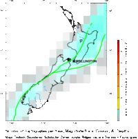
The largest city within the highest-risk zone is the nation's capital, Wellington, followed by Hastings then Napier. All these cities have experienced severe earthquakes since European settlement. About 14,000 earthquakes occur in and around the country each year, of which between 150 and 200 are big enough to be felt.[1] As a result, New Zealand has very stringent building regulations.
Quite early on, European settlers were faced with the reality of earthquakes in their new home. On 26 May 1840, the new settlement at Port Nicholson was struck by the first of a number of earthquakes and tremors. Early settlers learned fairly quickly the importance of using appropriate building methods in an earthquake-prone country. The 1848 earthquake, centred in Marlborough, caused great damage to the brick and masonry buildings in Wellington, and the city was rebuilt mainly in wood; consequently it suffered comparatively little damage in the 8.2 magnitude earthquake of 1855, which lifted the land 2–3m.[3] Many buildings in Hastings and Napier were damaged in the 1931 Hawke's Bay earthquake. New building regulations meant that any new buildings constructed afterwards attempted to take earthquake shaking into account in building design.[3]
Pre-19th century
19th century
Information for earthquakes before 1840 are later estimates.
1900–1949
| Date | Location | Region | Magnitude (ML) | Magnitude (MW) | Depth | Latitude | Longitude | Fatalities | Further information |
|---|
| 16 Nov 1901 | Cheviot | North Canterbury | 6.8 [41] | | 12 km | 42.74°S | 173.35°E | 1 | 1901 Cheviot earthquake |
| 9 Aug 1904 | Cape Turnagain | Hawke's Bay | 7.0 [42] | 7.2 | 16 km | 40.40°S | 176.40°E | | 1904 Cape Turnagain earthquake |
| 7 Oct 1914 | East Cape | Gisborne | 6.6 [43] | | 12 km | 37.80°S | 178.20°E | | Felt throughout eastern North Island |
| 22 Nov 1914 | Tauranga | Bay of Plenty | 7.3 [44] | | 300 km | 37.49°S | 176.50°E | | Felt throughout North Island |
| 1 May 1917 | Raoul Island | Kermadec Islands | | 8.0 | 50 km | 29.00°S | 177.00°W | | Felt throughout New Zealand[45] |
| 6 Aug 1917 | Castlepoint | Manawatu | 6.8 [46] | | 12 km | 40.80°S | 176.00°E | | Felt throughout North Island |
| 3 Nov 1918 | Puysegur Trench | South of New Zealand | 6.8 [47] | | 50 km | 47.00°S | 165.40°E | | Felt throughout Southland |
| 29 Jun 1921 | Kaweka Forest | Hawke's Bay | 7.0 [48] | | 80 km | 39.29°S | 176.40°E | | Felt throughout North Island |
| 25 Dec 1922 | Motunau | North Canterbury | 6.4 | | 20 km | 42.99°S | 173.00°E | | Felt throughout Upper half of South Island |
| 9 Mar 1929 | Arthur's Pass | Canterbury | 7.0 [49] | | 12 km | 42.83°S | 171.83°E | | 1929 Arthur's Pass earthquake |
| 17 Jun 1929 | Murchison | West Coast | 7.3 [50] | 7.8 | 20 km | 41.69°S | 172.20°E | 17 | 1929 Murchison earthquake |
| 23 Jun 1929 | Murchison | West Coast | 6.5 [51] | | 12 km | 41.78°S | 172.32°E | | |
| 12 Feb 1930 | Porangahau | Hawke's Bay | 6.2 | | 33 km | 40.39°S | 176.55°E | | Felt throughout lower half of North Island |
| 3 Feb 1931 | North of Napier | Hawke's Bay | 7.4 [52] | 7.8 | 20 km | 39.29°S | 177.00°E | 256 | 1931 Hawke's Bay earthquake |
| 13 Feb 1931 | East of Napier | Hawke's Bay | 7.3 [53] | | 30 km | 39.55°S | 177.31°E | | Aftershock to M 7.4 event |
| 16 Sep 1932 | Wairoa | Hawke's Bay | 6.9 [54] | | 12 km | 38.95°S | 177.59°E | | Caused further damage to the already devastated Hawke's Bay. |
| 5 Mar 1934 | Pahiatua | Manawatu | 7.2 [55] | | 12 km | 40.54°S | 176.29°E | 2 | 1934 Pahiatua earthquake |
| 15 Mar 1934 | Wairoa | Hawke's Bay | 6.3 | | 25 km | 39.31°S | 177.23°E | | Felt strongly in Hawke's Bay and Gisborne |
| 24 May 1936 | Whakatane | Bay of Plenty | 6.5 [56] | | 150 km | 37.99°S | 177.00°E | | Felt in North Island |
| 16 Dec 1938 | Fiordland | Southland | 7.0 | | 60 km | 44.99°S | 167.00°E | | Felt throughout South Island |
| 11 Feb 1939 | Fiordland | Southland | 7.0 [57] | | 25 km | 45.00°S | 167.50°E | | Felt throughout South Island |
| 26 Feb 1940 | Hastings | Hawke's Bay | 6.0 | | 25 km | 39.50°S | 176.50°E | | Felt throughout North Island |
| 24 Jun 1942 | Masterton | Wairarapa | 6.9 [58] | | 12 km | 40.96°S | 175.69°E | 1[59] | June 1942 Wairarapa earthquake |
| 1 Aug 1942 | Masterton | Wairarapa | 6.8 [60] | | 40 km | 41.01°S | 175.52°E | 1 | August 1942 Wairarapa earthquake |
| 17 Feb 1943 | Te Anau | Southland | 6.5 | | 123 km | 45.29°S | 168.00°E | | Felt throughout South Island |
| 2 Aug 1943 | Te Anau | Southland | 6.1 [61] | | 33 km | 45.64°S | 166.67°E | | Felt throughout South Island |
| 2 Sep 1945 | Stewart Island | Southland | 6.5 [62] | | 12 km | 47.47°S, | 166.12°E | | Felt throughout Southland and Otago |
| 26 Jun 1946 | Lake Coleridge | Canterbury | 6.2 [63] | | 12 km | 43.30°S | 171.47°E | | Mainshock |
| 26 Mar 1947 | Offshore Poverty Bay | Gisborne | 7.1 | | | 38.55°S | 178.42°E | | 1947 Gisborne earthquakes and tsunami |
| 17 May 1947 | Offshore Tolaga Bay | Gisborne | 7.1 | | | 38.21°S | 178.60°E | | 1947 Gisborne earthquakes and tsunami |
| 22 May 1948 | Hanmer Springs | North Canterbury | 6.4 | | 12 km | 42.49°S | 173.00°E | | Mainshock |
| 22 May 1948 | Cheviot | North Canterbury | 6.2 | | 12 km | 42.83°S | 173.05°E | | Separate event triggered by the M 6.4 earthquake 5 minutes prior |
| 9 Feb 1949 | Hawera | Taranaki | 6.4 | | 199 km | 39.67°S | 174.35°E | | Felt throughout North Island |
1950–1999
| Date | Location | Region | Magnitude (ML) | Magnitude (MW) | Depth | Latitude | Longitude | Fatalities | Further information |
|---|
| 10 Feb 1951 | Porangahau | Hawke's Bay | 6.1 | | 33 km | 40.21°S | 177.04°E | | Felt throughout North Island [64] |
| 24 Jun 1951 | Toaroa Junction | Manawatu | 6.3 | | 33 km | 39.45°S | 176.20°E | | Felt throughout North Island |
| 29 Sep 1953 | Tauranga | Bay of Plenty | 7.2 [65] | | 273 km | 37.59°S | 176.48°E | | Felt throughout North Island |
| 27 Feb 1955 | Raoul Island | Kermadec Islands | 7.8 | | 18 km | 28.40°S | 175.37°W | | Felt in the East half of North Island |
| 29 Dec 1956 | Matawai | Gisborne | 6.1 | 6.1 | 33 km | 39.72°S | 176.87°E | | Felt strongly along the East Coast of the North Island |
| 31 Jan 1958 | Waipawa | Hawke's Bay | 6.1 | | 12 km | 30.30°S | 177.50°E | | |
| 14 Sep 1959 | Raoul Island | Kermadec Islands | | 7.8 | 35 km | 28.82°S | 177.07°W | | Felt in the East half of North Island |
| 28 Mar 1960 | Mokau | Taranaki | 6.6 [66] | | 237 km | 39.04°S | 174.81°E | | Doublet earthquake to 6.5 event |
| 28 Mar 1960 | Mokau | Taranaki | 6.5 [67] | | 209 km | 39.04°S | 174.77°E | | Doublet earthquake to 6.6 event |
| 25 May 1960 | Milford Sound | Southland | 6.3 | | 12 km | 44.17°S | 167.72°E | | |
| 27 Dec 1961 | Martinborough | Wellington | 6.2 | | 12 km | 41.51°S | 176.11°E | | Struck offshore, 65 km east of Martinborough |
| 18 Dec 1963 | Raoul Islands | Kermadec Islands | | 7.7 | 35 km | 24.77°S | 176.52°W | | Felt in the East half of North Island |
| 11 April 1965 | Kaikoura | North Canterbury | 6.1 | | 12 km | 42.76°S | 173.87°E | | Felt in Kaikoura/North Canterbury |
| 21 May 1965 | George Sound | Southland | 6.4 | | 101 km | 44.94°S | 167.36°E | | |
| 4 Mar 1966 | Gisborne | East Cape | 6.0 | | 33 km | 38.73°S | 178.11°E | | Felt in Gisborne |
| 23 April 1966 | Cook Strait | Marlborough | 5.8 | 5.8 | 12 km | 41.64°S | 174.54°E | | Caused damage in Wellington |
| 24 May 1968 | Inangahua Junction | West Coast | 6.7[68] | 7.1[68] | 12 km | 41.75°S | 172.04°E | 2 | 1968 Inangahua earthquake |
| 6 Jan 1973 | Taupo | Waikato | 7.0 | | 163 km | 39.03°S | 175.26°E | | Felt throughout New Zealand |
| 5 May 1976 | Milford Sound | Southland | 6.6 | | 12 km | 44.67°S | 167.38°E | | |
| 15 Jan 1976 | Raoul Island | Kermadec Islands | | 7.8 | 43 km | 29.21°S | 177.63°W | | Foreshock to M 8.2 event |
| 15 Jan 1976 | Raoul Island | Kermadec Islands | | 8.2 | 31 km | 29.17°S | 177.31°W | | Main shock |
| 18 Jan 1977 | Cook Strait | Marlborough | 6.0 | | 33 km | 41.84°S | 174.58°E | | |
| 12 Oct 1979 | Puysegur Trench | South of New Zealand | 6.5 | | 12 km | 46.70°S | 166.03°E | | |
| 31 Dec 1984 | White Island | Bay of Plenty | 6.3 | | 12 km | 36.59°S | 177.55°E | | Felt around the Bay of Plenty |
| 21 Oct 1986 | Raoul Island | Kermadec Islands | | 8.3 | 33 km | 28.15°S | 176.29°W | | Felt throughout New Zealand[69] |
| 2 Mar 1987 | Edgecumbe | Bay of Plenty | 6.1 | 6.5 | 10 km | 37.88°S | 176.80°E | | 1987 Edgecumbe earthquake |
| 4 Jun 1988 | Te Anau | Southland | 6.1 | | 73 km | 45.12°S | 167.29°E | | |
| 24 May 1989 | Puysegur Trench | South of New Zealand | | 8.2 | | | | | Felt in the South Island |
| 31 May 1989 | Doubtful Sound | Southland | 6.1 | | 23 km | 45.33°S | 166.87°E | | |
| 13 May 1990 | Weber | Manawatu | 6.2[70] | 6.4[70] | 29 km | 40.42S | 176.47°E | | Mainshock |
| 28 Jan 1991 | Buller Ranges | West Coast | 6.1 | | 9.9 km | 41.90°S | 171.65°E | | Foreshock to M 6.3 event |
| 29 Jan 1991 | Buller Ranges | West Coast | 6.3 | | 17.3 km | 41.90°S | 171.72°E | | Mainshock |
| 8 Sep 1991 | South Taranaki Bight | Manawatu | 6.3 | | 86 km | 40.24°S | 175.16°E | | Felt throughout North Island |
| 27 May 1992 | Wairau Valley | Marlborough | 6.8 | | 79 km | 41.60°S | 173.66°E | | Felt in Central New Zealand |
| 21 June 1992 | White Island | Bay of Plenty | 6.1 | | 5 km | 37.57°S | 176.82°E | | Felt in Bay of Plenty |
| 10 Aug 1993 | Secretary Island | Southland | 6.7 | 7.0 | 5 km | 45.21°S | 166.70°E | | Felt as far away as Australia |
| 10 Aug 1993 | Gisborne | East Cape | 6.3 | | 45 km | 38.52°S | 177.90°E | | Felt strongly in Gisborne. |
| 11 Apr 1993 | Hastings | Hawke's Bay | 6.1 | | 37 km | 39.72°S | 176.71°E | | Felt strongly throughout Hawke's Bay |
| 18 Jun 1994 | Arthur's Pass | Canterbury | 6.7 [71] | 6.7 | 4 km | 43.00°S | 171.47°E | | Mainshock |
| 19 Jun 1994 | Lake Coleridge | Canterbury | 6.1 | | 5 km | 43.16°S, | 171.47°E | | Triggered from the M 6.7 Arthur's Pass event |
| 24 Nov 1995 | Arthur's Pass | Canterbury | 6.3 | | 7 km | 42.95°S, | 171.81°E | | Felt strongly in the South Island |
| 6 Feb 1995 | NE of New Zealand | East Cape | 7.0 | | 12 km | 37.7°7S | 179.68°E | | Mainshock |
| 10 Feb 1995 | NE of New Zealand | East Cape | 6.6 | | 12 km | 37.92°7S | 179.51°E | | |
| 25 May 1997 | Raoul Island | Kermadec Islands | | 7.9 | 339 km | 33.61°S | 177.80°E | | Felt throughout North Island and upper half of South Island |
| 20 Apr 1998 | Taumaranui | Manawatu | 6.7 [72] | | 232 km | 39,02S | 174.92°E | | Felt throughout the North Island |
| 25 Oct 1999 | Taupo | Waikato | 7.0 | | 160 km | 38.56S | 175.91°E | | Felt throughout New Zealand |
2000–2009
| Date | Location | Region | Magnitude (ML) | Magnitude (MW) | Depth | Latitude | Longitude | Fatalities | Further information |
|---|
| 15 Aug 2000 | L'Esperance Rock | Kermadec Islands | 7.6 [73] | | 436 km | 31.94°S | 178.55°E | | Felt in Christchurch |
| 1 Nov 2000 | Fiordland | Southland | 6.2 [74] | | 9 km | 45.12°S | 166.95°E | | |
| 21 Aug 2001 | NE of New Zealand | East Cape | 7.1 [75] | 7.1 | 33 km | 36.98°S | 179.16°E | | Felt in the Gisborne area |
| 21 Oct 2001 | NE of New Zealand | East Cape | 6.3 | | 12 km | 36.89°S | 179.86°E | | Felt in the Gisborne area |
| 8 Dec 2001 | Haast | West Coast | 6.2 | | 5 km | 44.11°S | 168.60°E | | Mainshock |
| 22 Aug 2003 | Fiordland | Southland | 7.0 [76] | 7.2 | 24 km | 45.19°S, | 166.83°E | | Felt throughout South Island |
| 22 Nov 2004 | Puysegur Trench | South of New Zealand | 7.1 [77] | 7.0 | 12 km | 46.57°S | 165.08°E | | Reportedly felt as far north as Hamilton. |
| 14 Mar 2005 | Opunake | Manawatu-Wanganui | 6.4 | | 154 km | 40.17°S | 173.63°E | | Felt strongly throughout central New Zealand |
| 16 May 2006 | L'Esperance Rock | Kermadec Islands | 7.5 [78] | 7.4 | 150 km | 31.56°S, | 179.30°W | | Felt in East half of New Zealand |
| 16 May 2006 | Raoul Island | Kermadec Islands | 7.1 | | 33 km | 31.98°S, | 177.21°W | | Felt in East half on North Island |
| 16 Oct 2007 | Fiordland | Southland | 6.7 [79] | 6.7 | 5 km | 44.72°S | 167.39°E | | Felt lower half of South Island |
| 9 Dec 2007 | Raoul Island | Kermadec Islands | | 7.8 | 152 km | 25.99°S | 177.51°W | | Felt in East half of New Zealand |
| 20 Dec 2007 | Gisborne | East Cape | 6.7 [80] | 6.6 | 44 km | 38.89°S | 178.44°E | | 2007 Gisborne earthquake |
| 25 Aug 2008 | Hastings | Hawke's Bay | 5.9 | | 31 km | 39.71°S | 176.85°E | | 2008 Hastings earthquake |
| 15 Jul 2009 | Puysegur Trench | South of New Zealand | 6.1 [81] | | 33 km | 46.07°S | 165.75°E | | Felt throughout Southland and Otago |
| 15 Jul 2009 | Dusky Sound | Southland | | 7.8 [82] | 12 km | 45.76°S | 166.58°E | | 2009 Fiordland earthquake |
2010–present
See also
References
- Specific
- ↑ McSaveney, Eileen (12 June 2006). "Earthquakes - What causes earthquakes?". Te Ara - the Encyclopedia of New Zealand. Retrieved 3 September 2016.
- 1 2 McSaveney, Eileen (21 September 2007). "Earthquakes - Building for earthquake resistance". Te Ara - the Encyclopedia of New Zealand.
- 1 2 3 "Alpine Fault". GNS Science. Retrieved 29 November 2011.
- ↑ Maclean, Chris (3 March 2009). "Creation stories and landscape - Wellington region". Te Ara Encyclopedia of New Zealand. Retrieved 29 November 2011.
- 1 2 Louise E. Cullen, Richard P. Duncan, Andrew Wells & Glenn H. Stewart (2003). "Floodplain and regional scale variation in earthquake effects on forests, Westland, New Zealand". Journal of the Royal Society of New Zealand. 33 (4). doi:10.1080/03014223.2003.9517753. Retrieved 29 November 2011.
- ↑ "GeoNet - Quakes". Retrieved 15 September 2016.
- ↑ "GeoNet - Quakes". Retrieved 15 September 2016.
- ↑ "GeoNet - Quakes". Retrieved 15 September 2016.
- ↑ "GeoNet - Quakes". Retrieved 15 September 2016.
- ↑ "GeoNet - Quakes". Retrieved 15 September 2016.
- ↑ "GeoNet - Quakes". Retrieved 15 September 2016.
- ↑ "GeoNet - Quakes". Retrieved 15 September 2016.
- ↑ "GeoNet - Quakes". Retrieved 15 September 2016.
- ↑ "GeoNet - Quakes". Retrieved 15 September 2016.
- ↑ "GeoNet - Quakes". Retrieved 15 September 2016.
- ↑ "GeoNet - Quakes". Retrieved 15 September 2016.
- ↑ "GeoNet - Quakes". Retrieved 15 September 2016.
- ↑ "GeoNet - Quakes". Retrieved 22 November 2016.
- ↑ GeoNet. "M 8.2, Wairarapa, January 23, 1855". Retrieved 22 November 2016.
- ↑ McSaveney, M.J., Graham, I.J., Begg, J.G., Beu, A.G., Hull, A.G., Kyeong, K. & Zondervan, A. (2006). "Late Holocene uplift of beach ridges at Turakirae Head, south Wellington coast, New Zealand". New Zealand Journal of Geology and Geophysics. 49 (3): 337–358. doi:10.1080/00288306.2006.9515172. Retrieved 3 September 2016.
- ↑ Rodgers, D.W.; Little T.A. (2006). "World's largest coseismic strike-slip offset: The 1855 rupture of the Wairarapa Fault, New Zealand, and implications for displacement/length scaling of continental earthquakes". Journal of Geophysical Research. 111 (B12408). Bibcode:2006JGRB..11112408R. doi:10.1029/2005JB004065.
- ↑ McSaveney, Eileen (2 Mar 2009). "Historic earthquakes – The 1855 Wairarapa earthquake". Te Ara - the Encyclopedia of New Zealand. Retrieved 26 December 2011.
- ↑ "GeoNet - Quakes". Retrieved 22 November 2016.
- ↑ "Where were New Zealand's largest earthquakes?". GNS Science. Retrieved 3 September 2016.
- ↑ "Earthquakes". Archived from the original on July 16, 2014. Retrieved October 22, 2014.
- ↑ "GeoNet - Quakes". Retrieved 15 September 2016.
- ↑ GeoNet. "M 7.2 - 7.6, Cape Farewell, 19 October 1868". Retrieved 22 November 2016.
- ↑ "GeoNet - Quakes". Retrieved 22 November 2016.
- ↑ Pettinga, J.R.; Yetton M.D.; Van Dissen R.J. & Downes G. (2001). "Earthquake source identification and characterisation for the Canterbury Region, South Island, New Zealand" (PDF). Bulletin of the New Zealand Society for Earthquake Engineering. 34 (4): 307. Retrieved 22 November 2016.
- ↑ "GeoNet - Quakes". Retrieved 15 September 2016.
- ↑ "GeoNet - Quakes". Retrieved 15 September 2016.
- ↑ "New Zealand's deadliest earthquakes and past earthquakes in Christchurch". Natural Hazards Research Platform. Retrieved 6 June 2012.
- ↑ "GeoNet - Quakes". Retrieved 15 September 2016.
- ↑ "City Council". The Star (4263). 20 December 1881. p. 4. Retrieved 14 April 2013.
- ↑ "GeoNet - Quakes". Retrieved 15 September 2016.
- ↑ "GeoNet - Quakes". Retrieved 15 September 2016.
- ↑ "GeoNet - Quakes". Retrieved 15 September 2016.
- ↑ "GeoNet - Quakes". Retrieved 15 September 2016.
- ↑ "GeoNet - Quakes". Retrieved 15 September 2016.
- ↑ "GeoNet - Quakes". Retrieved 15 September 2016.
- ↑ "GeoNet - Quakes". Retrieved 15 September 2016.
- ↑ "GeoNet - Quakes". Retrieved 15 September 2016.
- ↑ "GeoNet - Quakes". Retrieved 15 September 2016.
- ↑ "Magnitude 8 and Greater Earthquakes Since 1900". United States Geological Survey. Retrieved 15 March 2012.
- ↑ "GeoNet - Quakes". Retrieved 15 September 2016.
- ↑ "GeoNet - Quakes". Retrieved 15 September 2016.
- ↑ "GeoNet - Quakes". Retrieved 15 September 2016.
- ↑ "GeoNet - Quakes". Retrieved 15 September 2016.
- ↑ "GeoNet - Quakes". Retrieved 15 September 2016.
- ↑ "GeoNet - Quakes". Retrieved 15 September 2016.
- ↑ "GeoNet - Quakes". Retrieved 15 September 2016.
- ↑ "GeoNet - Quakes". Retrieved 15 September 2016.
- ↑ "GeoNet - Quakes". Retrieved 15 September 2016.
- ↑ "GeoNet - Quakes". Retrieved 15 September 2016.
- ↑ "GeoNet - Quakes". Retrieved 15 September 2016.
- ↑ "GeoNet - Quakes". Retrieved 15 September 2016.
- ↑ "GeoNet - Quakes". Retrieved 15 September 2016.
- ↑ M 7.2, Wairarapa I, 24 June 1942 Geonet Retrieved 18 November 2016
- ↑ "GeoNet - Quakes". Retrieved 15 September 2016.
- ↑ "GeoNet - Quakes". Retrieved 15 September 2016.
- ↑ "GeoNet - Quakes". Retrieved 15 September 2016.
- ↑ "GeoNet - Quakes". Retrieved 15 September 2016.
- ↑ "Quakes". GeoNet.org.nz. 1951-02-10. Retrieved 2016-02-02.
- ↑ "GeoNet - Quakes". Retrieved 15 September 2016.
- ↑ "GeoNet - Quakes". Retrieved 15 September 2016.
- ↑ "GeoNet - Quakes". Retrieved 15 September 2016.
- 1 2 "M 7.1, Inangahua, 24 May 1968". GeoNet. GNS Science. Retrieved 19 November 2016.
- ↑ "Significant Earthquakes of the World". United States Geological Survey. Retrieved 15 March 2012.
- 1 2 http://info.geonet.org.nz/display/quake/M+6.4,+Weber+II,+13+May+1990. Geonet
- ↑ "GeoNet - Quakes". Retrieved 15 September 2016.
- ↑ "GeoNet - Quakes". Retrieved 15 September 2016.
- ↑ "GeoNet - Quakes". Retrieved 15 September 2016.
- ↑ "GeoNet - Quakes". Retrieved 15 September 2016.
- ↑ "GeoNet - Quakes". Retrieved 15 September 2016.
- ↑ "GeoNet - Quakes". Retrieved 15 September 2016.
- ↑ "GeoNet - Quakes". Retrieved 15 September 2016.
- ↑ "GeoNet - Quakes". Retrieved 15 September 2016.
- ↑ "GeoNet - Quakes". Retrieved 15 September 2016.
- ↑ "GeoNet - Quakes". Retrieved 15 September 2016.
- ↑ "GeoNet - Quakes". Retrieved 15 September 2016.
- ↑ "GeoNet - Quakes". Retrieved 15 September 2016.
- ↑ "GeoNet - Quakes". www.geonet.org.nz. Retrieved 2015-12-12.
- ↑ "M7.0 - South Island of New Zealand". earthquake.usgs.gov. Retrieved 2015-12-12.
- ↑ "List of deceased - Christchurch earthquake". New Zealand Police. 3 May 2011. Retrieved 31 May 2011.
- ↑ "GeoNet - Quakes". www.geonet.org.nz. Retrieved 2015-12-12.
- ↑ "M6.1 - South Island of New Zealand". earthquake.usgs.gov. Retrieved 2015-12-12.
- ↑ "GeoNet - Quakes". www.geonet.org.nz. Retrieved 2015-12-12.
- ↑ "M5.9 - South Island of New Zealand". earthquake.usgs.gov. Retrieved 2015-12-12.
- ↑ "GeoNet - Quakes". www.geonet.org.nz. Retrieved 2015-12-12.
- ↑ "M5.5 - North Island of New Zealand". earthquake.usgs.gov. Retrieved 2015-12-12.
- ↑ "GeoNet - Quakes". www.geonet.org.nz. Retrieved 2015-12-12.
- ↑ "M7.6 - Kermadec Islands region". earthquake.usgs.gov. Retrieved 2015-12-12.
- ↑ "GeoNet - Quakes". www.geonet.org.nz. Retrieved 2015-12-12.
- ↑ "M7.4 - Kermadec Islands region". earthquake.usgs.gov. Retrieved 2015-12-12.
- ↑ "GeoNet - Quakes". www.geonet.org.nz. Retrieved 2015-12-12.
- ↑ "M5.9 - South Island of New Zealand". earthquake.usgs.gov. Retrieved 2015-12-12.
- ↑ "GeoNet - Quakes". www.geonet.org.nz. Retrieved 2015-12-12.
- ↑ "M6.3 - Cook Strait, New Zealand". earthquake.usgs.gov. Retrieved 2015-12-12.
- ↑ "New Zealand Earthquake Report -- Magnitude 6.5, Sunday, July 21, 2013 at 5:09:30 pm (NZST)". GNS Science. Retrieved 21 July 2013.
- ↑ "M6.5 - 46km ESE of Blenheim, New Zealand". earthquake.usgs.gov. Retrieved 2015-12-12.
- ↑ "New Zealand Earthquake Report -- Magnitude 6.6, Friday, August 16, 2013 at 2:31:05 pm (NZST)". GNS Science. Retrieved 17 August 2013.
- ↑ "M6.5 - 29km SE of Blenheim, New Zealand". earthquake.usgs.gov. Retrieved 2015-12-12.
- ↑ "New Zealand Earthquake Report -- Magnitude 6.0, Friday, 16 August 2013 at 5:31:16 pm (NZST)". GNS Science. Retrieved 6 September 2013.
- ↑ "M5.9 - 30km ESE of Blenheim, New Zealand". earthquake.usgs.gov. Retrieved 2015-12-12.
- ↑ "New Zealand Earthquake Report Magnitude 6.2, Monday, January 20, 2014 at 3:52:45 pm (NZDT)". GeoNet. 21 January 2014. Retrieved 21 January 2014.
- ↑ "M6.1 - 35km NNE of Masterton, New Zealand". earthquake.usgs.gov. Retrieved 2015-12-12.
- ↑ "New Zealand Earthquake Report Magnitude 6.2, Mon, Oct 13 2014, 6:13:41 pm (NZDT)". GNS Science. Retrieved 13 October 2014.
- ↑ "M5.8 - 159km W of Riverton, New Zealand". earthquake.usgs.gov. Retrieved 2015-12-12.
- ↑ "New Zealand Earthquake Report Magnitude 6.5, Tue, Oct 14 2014, 5:12:30 pm (NZDT)". GNS Science. Retrieved 14 October 2014.
- ↑ "M5.7 - South of the Kermadec Islands". earthquake.usgs.gov. Retrieved 2015-12-12.
- ↑ "GeoNet - Quakes". www.geonet.org.nz. Retrieved 2015-12-12.
- ↑ "M6.7 - 183km NE of Gisborne, New Zealand". earthquake.usgs.gov. Retrieved 2015-12-12.
- ↑ "GeoNet - Quakes". geonet.org.nz. Retrieved 2015-12-12.
- ↑ "M5.6 - 43km SSE of Hokitika, New Zealand". earthquake.usgs.gov. Retrieved 2015-12-12.
- ↑ "GeoNet - Quakes". geonet.org.nz. Retrieved 2015-12-12.
- ↑ "M6.1 - 67km NW of Kaikoura, New Zealand". earthquake.usgs.gov. Retrieved 2015-12-12.
- ↑ "GeoNet - Quakes". geonet.org.nz. Retrieved 2016-02-03.
- ↑ "5.9 magnitude earthquake hits near Christchurch, New Zealand". smh.com.au. Retrieved 2016-02-14.
- ↑ "GeoNet - Quakes - Magnitude 5.7, Sun, Feb 14 2016, 1:13:43 pm (NZDT)". geonet.org.nz. Retrieved 2016-02-14.
- ↑ "Magnitude 7.1, Fri, Sep 2 2016, 4:37:55 am (NZST)". geonet.org.nz. Retrieved 2016-09-04.
- ↑ "M7.1 - 166km NE of Gisborne, New Zealand". earthquake.usgs.gov. Retrieved 2016-09-04.
- ↑ "Magnitude 7.8, Mon, Nov 14 2016, 12:02:56 am (NZDT)". GeoNet. Retrieved 16 November 2016.
- ↑ "M7.8 – 53km NNE of Amberley, New Zealand". United States Geological Survey. 13 November 2016. Retrieved 19 November 2016.
- ↑ Elvey, Suz; Walker, Marc; Kitching, Chris. "Two deaths reported as quake recovery continues". Mirror.co.uk. Retrieved 13 November 2016.
- ↑ "M7.8 – 53km NNE of Amberley, New Zealand: Origin". earthquake.usgs.gov. United States Geological Survey. Retrieved 2016-11-13.
- General
- Dench, Alison (2005). Essential Dates: A Timeline of New Zealand History. Auckland: Random House. ISBN 1-86941-689-9.
- Eiby, G. A. (1957); Earthquakes (London, Frederick Muller) Page 159 has Table of (16) Major Earthquakes in New Zealand 1848–1942, from R. C. Hayes.
- Henderson, J (1937); The West Nelson Earthquakes of 1929, Bulletin No. 55 of Department of Scientific and Industrial Research (Wellington, Government Printer)
External links
|
|---|
|
| Pre-colonisation |
- 1100 Alpine Fault
- 1460 Wellington
- 1600s Alpine Fault
- 1717 Alpine Fault
- 1815 New Plymouth
- 1817 Fiordland
- 1826 Fiordland
- 1835 Manukau
- 1838 Waitotara Forest
|
|---|
|
| 19th century | |
|---|
|
| 20th century | |
|---|
|
| 21st century | |
|---|
|
| Related articles | |
|---|
|
- † indicates earthquake known to have resulted in fatalities
|