List of heritage sites in Free State
This is a list of the heritage sites in Free State as recognized by the South African Heritage Resource Agency.
| SAHRA identifier | Site name | Description | Town | District | NHRA status | Coordinates | Image |
|---|---|---|---|---|---|---|---|
| 2/0/BEH/6 | 1 Olivier Street, Kestell, Bethlehem District | Kestell | Bethlehem | Register | 28°18′42″S 28°42′14″E / 28.311748°S 28.703842°E | 
| |
| 9/2/300/0001 | Farmhouse and outbuildings, Wolhuterskop-Zuid, Bethlehem District | Type of site: Farmstead. Current use: Tourism. The original portion of the sandstone homestead was according to oral traditional erected in about 1850 by Philip Roedolf Fourie, the first owner of Wolhuterskop. Once restored the homestead, outbuildings and cemetery can serve as a fine example of a typ | Bethlehem | Provisional Protection | 28°15′30″S 28°18′00″E / 28.2583333333°S 28.3°E |
| |
| 9/2/300/0003 | 2 Olivier Street, Kestell, Bethlehem District | Erected by Dr Andrew Craig Hunter who bought the property in 1911 from John Pringle Cooke. Type of site: House. Previous use: Dwelling-house. Current use: Dwelling-house. | Kestell | Bethlehem | Provincial Heritage Site | 28°18′42″S 28°42′12″E / 28.311675°S 28.703369°E |
|
| 9/2/300/0004 | Wooden Spoon Braairestaurant, 12 Church Street, Bethlehem | The building has an interesting building style because of the sandstone and blue-stone that is miced. This 'Tuishuisie' is the oldest existing building in Bethlehem and was built in 1874 by Mr Johannes Blignaut Type of site: Commercial Previous use: Shop. This "Tuishuisie" is the oldest existing building in Bethlehem and was presumably erected before 1880. | Bethlehem | Bethlehem | Provincial Heritage Site | 28°29′58″S 27°56′10″E / 28.499575°S 27.936087°E |
|
| 9/2/300/0005 | St Andrew's Presbyterian Church, 144 Cambridge Street, Bethlehem | Type of site: Church Current use: Church. This sandstone building is typical of the English church architecture found earlier in most Free State | Bethlehem | Bethlehem | Provincial Heritage Site | 28°18′15″S 28°14′01″E / 28.30415°S 28.2334972222°E |
|
| 9/2/300/0006 | Preekstoelrots, Narwanda, Bethlehem District | This rock derives its name from its distinctive form. It also has historical significance because of | Bethlehem | Provincial Heritage Site | 28°27′15″S 26°47′48″E / 28.454111°S 26.796785°E |
| |
| 9/2/300/0008 | A B Baartman Wagon House, Muller and Landdros Streets, Bethlehem | This sturdy sandstone wagon house with its high-pitched iron roof and loft was erected in 1894 by A. A. Baartman, builder of wagons, carts and spiders. The adjacent outbuildings were added after the Anglo-Boer War (1899-1902). Type of site: House Previous use: Other: Wagon-house. Current use: Museum. It was erected in 1894 by A.A. Baartm | Bethlehem | Bethlehem | Provincial Heritage Site | 28°13′55″S 28°18′58″E / 28.232027°S 28.316208°E |
|
| 9/2/300/0009 | Nederduitse Gereformeerde Mother Church, Church Square, Bethlehem | The cornerstone of this impressive sandstone church building, which was designed by the Revd. J. D. Kestell, was laid by President M. T. Steyn on 12 April 1910. The church was inaugurated on 18 February 1911. The Basuto War (1865--66) Memorial was erected Type of site: Church. The cornerstone of this impressive sandstone church building, which was designed by the Revd. J. D. Kestell, was laid by President M. T. Steyn on 12 April 1910. The church was inaugurated on 18 February 1911. | Bethlehem | Bethlehem | Provincial Heritage Site | 28°14′02″S 28°18′39″E / 28.233852°S 28.310823°E |  |
| 9/2/300/0010 | 14 President Burgers Street, Bethlehem | It is a plastered brick house with a pitched corrugated iron roof. It has a corrugated iron veranda The original portion of the house was built just after the Anglo-Boer War (1899-1902). Type of site: Commercial / Residential Previous use: House. Current use: Restaurant. This cottage, of which the original portion was erected just after the Second Anglo-Boer War (1899-1902), is an excellent example of a town house at the turn of the century. | Bethlehem | Bethlehem | Provincial Heritage Site | 28°14′12″S 28°18′40″E / 28.236716°S 28.311036°E |
|
| 9/2/300/0013 | St Augustine Anglican Church, 34 Louw Street, Bethlehem | Sandstone building with tile roof and sandstone buttresses against walls. Sandstone apse on eastern The cornerstone of the building was laid on 1928-02-29 by Rev. George Belbin. The completed church w Type of site: Church Current use: Church. This church was completed on 1928-08-26 | Bethlehem | Bethlehem | Provincial Heritage Site | 28°18′34″S 28°14′06″E / 28.3095527777°S 28.23495°E |
|
| 9/2/300/0016 | Nederduitse Gereformeerde Church, Van Riebeeck Street, Kestell, Bethlehem District | This sandstone church with a corrugated iron roof has Byzantine and Neoclassical elements. This impressive sandstone church with its Byzantine and neoclassical elements was designed by the well-known architect Gerhard Moerdyk and erected by the builder F. Barker. This church, which is one of the largest stone churches in South Africa, was officially Architectural style: Neo-classical. Type of site: Church Current use: Church. | Kestell | Bethlehem | Provincial Heritage Site | 28°18′35″S 28°42′11″E / 28.309670°S 28.703063°E |  |
| 9/2/300/0017 | Strapp's Shop, 18 Church Street, Bethlehem | This Victorian shop of sandstone dates from the late nineteenth century and is an excellent example of the sandstone architecture of the Eastern Free State. It forms an integral part of a building complex that includes the Old Magistrate's Office and the . | Bethlehem | Bethlehem | Provincial Heritage Site | 28°14′05″S 28°18′35″E / 28.234708°S 28.309721°E |  |
| 9/2/300/0018 | Pretoriuskloof Nature Reserve, Bethlehem | The nature reserve consist of two parts. One part is for visitors and the other is a route for natu Pretoriuskloof is a nature reserve for birds and small game. The reserve is situated in the centre o Type of site: Nature Reserve Current use: Nature reserve. The original fountain from which the fi | Bethlehem | Bethlehem | Provincial Heritage Site | 28°14′28″S 28°18′36″E / 28.241100°S 28.310100°E |
|
| 9/2/300/0018-001 | Loch Athlone Dam Wall, Pretoriuskloof Nature Reserve, Bethlehem | Current use: Dam wall. | Bethlehem | Bethlehem | Provincial Heritage Site | 28°15′01″S 28°18′32″E / 28.250354°S 28.308782°E |
|
| 9/2/300/0019 | Town Hall, 20-22 Muller Street, Bethlehem | Red brick building with tile roof and sandstone portico, quoining, foundation, window sills and lintels. Tower on south elevation. The cornerstones of the building were laid on 1993-01-30(???) by Councillor P Goble and the Administrator of the Orange Free State, C M T Wilcocks. The building contractor was John J Peddie. An additional wing was added to the north elevation in the 1950s Type of site: Town Hall Current use: Town Hall. The red brick building with its sandstone detail which was designed by F W Masey, was erected in 1930-1931. It is one of the most impressive town halls, built in the Free State and a landmark in Bethlehem. | Bethlehem | Bethlehem | Provincial Heritage Site | 28°18′28″S 28°13′57″E / 28.3077972222°S 28.2325361111°E |  |
| 9/2/300/0020 | The Seminary, Wessels Street, Bethlehem | It is a double-storeyed building with plastered sandstone walls and a pitched corrugated iron roof. This impressive sandstone building was erected in 1894 by the Dutch-Reformed Church to house the girls’ school known as the Seminary. Since 1903 the building has been used as a girls’ hostel by the co-educational Government school, except for a period of Type of site: Educational Previous use: School. Current use: Hostel. This impressive sandstone building was erected in 1894 by the Dutch-Reformed Church to house the girls’ school known as the Seminary. Since 1903 the building has been used as a girls’ hostel by the co-educational Government school, except for a period of | Bethlehem | Bethlehem | Provincial Heritage Site | 28°14′16″S 28°18′41″E / 28.237895°S 28.311365°E |
|
| 9/2/300/0021 | Old Magistrate's Court, Louw Street, Bethlehem | This sandstone building, the cornerstone of which was laid on 16 January 1893 by F. W. Reitz, State President of the Orange Free State, is an excellent example of the old Republican style of architecture, which was strongly influenced by the Renaissance s Type of site: Courthouse. This sandstone building, the cornerstone of which was laid on 16 January 1893 by F. W. Reitz, State President of the Orange Free State, is an excellent example of the old Republican style of architecture, which was strongly influenced by the Renaissance s | Bethlehem | Bethlehem | Provincial Heritage Site | 28°14′07″S 28°18′35″E / 28.235277°S 28.309761°E |
|
| 9/2/300/0023-001 | Library, Market Street West, Clarens | Type of site: Library. | Clarens | Bethlehem | Register | 28°30′53″S 28°25′13″E / 28.514730°S 28.420332°E |
|
| 9/2/300/0023-002 | Methodist Church, Bester Street, Clarens | Type of site: Church. | Clarens | Bethlehem | Register | 28°31′04″S 28°25′10″E / 28.517794°S 28.419469°E |  |
| 9/2/300/0023-003 | Nederduitse Gereformeerde Church, Main Street, Clarens | Type of site: Church. | Clarens | Bethlehem | Register | 28°30′59″S 28°25′08″E / 28.516512°S 28.419023°E |  |
| 9/2/300/0023-004 | Primary school building, Main Street, Clarens | Type of site: School. | Clarens | Bethlehem | Register | 28°31′10″S 28°24′56″E / 28.519515°S 28.415638°E |
|
| 9/2/300/0026 | Old Nederduitse Gereformeerde Mission Church, Muller Street, Bethlehem | The building is built of light sandstone and blue dolerite. The building is a typical example of the foundation stone of this church was laid on 22 December 1906 and the building was taken into use in 1909. It was only the second D.R. Mission Church to be erected in the Orange Free State. Type of site: Church Previous use: Church. Current use: Museum. The foundation stone of this church was laid on 22 December 1906 and the building was taken into use in 1909. It was only the second D.R. Mission Church to be erected in the Orange Free State. | Bethlehem | Bethlehem | Provincial Heritage Site | 28°13′53″S 28°18′55″E / 28.231460°S 28.315335°E |  |
| 9/2/300/0031 | Old Nederduitse Gereformeerde Mission Church parsonage, President Boshoff Street, Bethlehem | Type of site: Parsonage. The mission house derives its significance from its association with a religious figure, Rev. H.A. Roux who established himself in 1899 at Bethlehem as the first missionary of the Dutch Reformed Church in the town. He bought the erf with the original thr | Bethlehem | Bethlehem | Provincial Heritage Site | 28°13′59″S 28°18′29″E / 28.233143°S 28.308129°E |
|
| 9/2/300/0032 | Main Building, Technical College Bethlehem, Wessels Street, Bethlehem | Type of site: Educational. | Bethlehem | Bethlehem | Provincial Heritage Site | 28°14′18″S 28°18′27″E / 28.238393°S 28.307548°E |
|
| 9/2/300/0033 | Old Nederduitse Gereformeerde Church parsonage, Main Street, Clarens | Type of site: Parsonage. | Clarens | Bethlehem | Register | 28°30′59″S 28°25′08″E / 28.516482°S 28.418986°E |
|
| 9/2/301/0002 | Concentration Camp Cemetery, Bethulie | The garden of remembrance is laid out with slates. It is surrounded with a trellis. It has a sandst This cemetery contains the mortal remains of 1 737 women and children who died during the Anglo-Boer War (1899-1902) in the concentration camp at Bethulie. The cemetery, which was designed by J. do Toit, was inaugurated on 10 October 1966 by the then Stat Type of site: Concentration Camp Cemetery Current use: Cemetery. | Bethulie | Bethulie | Provincial Heritage Site | 30°29′05″S 25°59′57″E / 30.484829°S 25.999268°E |  |
| 9/2/301/0007 | Memorial and grave of Louw Wepener, Constantia, Bethulie District | The memorial is build out of sandstone. The memorial was erected in honour of Louw Wepener who had fight in the Basoeto War. In August 1865 Type of site: Grave, Memorial Previous use: Memorial. Current use: Memorial. | Bethulie | Provincial Heritage Site | 30°27′S 25°57′E / 30.45°S 25.95°E |  | |
| 9/2/301/0009 | Pellissier House Museum, Voortrekker Street, Bethulie | The middle part of the house has a pitched roof. The façade has a metal veranda that rest on iron pi This building was erected during the period 1834 to 1835 by the Rev. Jean Pierre Pellissier of the Paris Evangelical Missionary Society. It is one of the oldest existing buildings in the Orange Free State and dates from the period when missionary work mad Type of site: House Previous use: Personage. Current use: Museum. This building was erected during the period 1834 to 1835 by the Rev. Jean Pierre Pellissier of the Paris Evangelical Missionary Society. It is one of the oldest existing buildings in the Orange Free State and dates from the period when missionary work mad | Bethulie | Bethulie | Provincial Heritage Site | 30°29′38″S 25°58′31″E / 30.493841°S 25.975327°E |  |
| 9/2/301/0013 | Nederduitse Gereformeerde Church, Grey Street, Bethulie | It is a white T-shaped church with a grey painted pitched roof. In the middle of the façade is a tow This impressive T-formed church building with its Neo-Gothic features is one of the oldest existing Architectural style: Neo-Gothic. Type of site: Church Current use: Church. | Bethulie | Bethulie | Provincial Heritage Site | 30°29′48″S 25°58′25″E / 30.496660°S 25.973720°E |  |
| 9/2/302/0001-001 | Historic tree-garden, President Brand Street, Bloemfontein | It is trees planted in a garden. The trees in this garden serve as monuments to Pres. J.H. Brand, Lord Alfried Milner and various oth Type of site: Garden. | Bloemfontein | Bloemfontein | Provincial Heritage Site | 29°06′53″S 26°13′05″E / 29.114774°S 26.218051°E |  |
| 9/2/302/0001-005 | First University Building, University of the Orange Free State, Bloemfontein | This small red-brick building was erected in the early 20th century to serve as additional classrooms for Grey College from January 1904 to December 1907 the building served as the first headquarters of Grey University College. Type of site: University. This small red-brick building was erected in the early 20th century to serve as additional classrooms for Grey College from January 1904 to December 1907 the building served as the first headquarters of Grey University College. | Bloemfontein, Universitas | Bloemfontein | Provincial Heritage Site | 29°06′44″S 26°11′11″E / 29.112186°S 26.186374°E |  |
| 9/2/302/0002-001 | Sannaspos Battlefield, Ahmetnagher, Bloemfontein District | At this site along the Koringspruit, Gen. C. R. de Wet, Chief Commandant of the Orange Free State Commandos, outmanoeuvred the British forces under Brig. Gen. R. G. Broadwood on 31 March 1900. The military tactics displayed here by Gen. De Wet later became Type of site: Battlefield. | Bloemfontein | Provincial Heritage Site | 29°09′26″S 26°32′08″E / 29.157222°S 26.535550°E |
| |
| 9/2/302/0003 | President Brand Street Conservation Area, Bloemfontein | Type of site: Conservation area. | Bloemfontein | Bloemfontein | Heritage Area | 29°06′53″S 26°13′04″E / 29.11471°S 26.21776°E |
|
| 9/2/302/0005 | Archives Building, 37 Elizabeth Street, Bloemfontein | Type of site: Civic. | Bloemfontein | Bloemfontein | Provincial Heritage Site | 29°06′57″S 26°12′53″E / 29.11572°S 26.21486°E |
|
| 9/2/302/0006 | Old Prison, Bloemfontein | Type of site: Gaol. | Bloemfontein | Bloemfontein | Register | 29°07′00″S 26°13′00″E / 29.116667°S 26.216667°E |
|
| 9/2/302/0007 | Old Presidency, President Brand Street, Bloemfontein | This dignified presidential residence stands in Eunice Road, which is the extension of President Brand Street, just south of the Bloemspruit. Johan Nicolaas Brits built his simple ‘hartbeeshuisie’ about 300 metres from the spring, somewhere near the site of the Presidency. When Henry Warden arrived, Brits helped him to build a ‘kleihuis’ for his Residency on this site. This Residency was taken Type of site: Residency. | Bloemfontein | Bloemfontein | Provincial Heritage Site | 29°07′11″S 26°12′57″E / 29.11979°S 26.21583°E |  |
| 9/2/302/0010 | Tweetoring Church, Charles Street, Bloemfontein | The church is built in a modern Roman style. It has two towers of 106 feet high. It has place for 7 The Two Tower Church is closely connected with the historical past of the Orange Free State. The congregation was established in 1848 and on 6 May 1849, the Rev. Andrew Murray, Jr., was inducted as the first clergyman in the school building which was u Type of site: Church Previous use: Church. Current use: Church. HISTORICAL INTEREST
The Two Tower Church is closely connected with the historical past of the Orange Free State. The congregation was established in 1848 and on 6 May 1849, the Rev. Andrew Murray, Jr., was inducted as the first clergyman in the school |
Bloemfontein | Bloemfontein | Provincial Heritage Site | 29°06′57″S 26°13′20″E / 29.115715°S 26.222264°E |  |
| 9/2/302/0011 | Military Museum Fort Bloemfontein, Church Street, Bloemfontein | The Queen’s Fort, sometimes known as the Bloemfontein Fort, is situated to the south of the centre of the city. Partly hidden by large pine trees, it stands on a koppie to the left of Church Street, opposite the Basuto War Memorial.
On 3 February 1848, Previous use: Other: Aeroplane Motor. Current use: Museum. |
Bloemfontein | Bloemfontein | Provincial Heritage Site | 29°07′29″S 26°13′18″E / 29.124700°S 26.221567°E |  |
| 9/2/302/0013 | Fichardt House, 40 Elizabeth Street, Bloemfontein | It is a double-storeyed building with orange-red stone bricks and a corrugated iron roof. The building was registered in 1896. Mr C.G. Fichardt was responsible for the building. The building Architectural style: Queen - Anne. Type of site: Commercial Previous use: Clinic. Current use: Offices. | Bloemfontein | Bloemfontein | Provincial Heritage Site | 29°06′56″S 26°12′57″E / 29.11555°S 26.21572°E |
|
| 9/2/302/0014 | Mapikela House, 1436 Maghoti Street, Batho, Bloemfontein | It is a red brick double-storey building, with a pitched corrugated iron roof. There is a veranda wi The building known as the Mapikela House is closely associated with its owner and builder, T.M. Mapi Type of site: House Current use: Residential. This red brick double-storey house was built in 1926 by Mr Thomas Mtobi Mapikela. The house is of major historical importance because of its association with Mapikela, who was one of the founding fathers of the ANC and speaker of the organisation for more | Bloemfontein, Batho | Bloemfontein | Provisional Protection | 29°08′16″S 26°13′22″E / 29.137789°S 26.222761°E |
|
| 9/2/302/0016 | Old Railway Bureau, Maitland Street, Bloemfontein | It is a double-storyed brick building with Victorian and neoclassical characteristics. It is a mass This double-storeyed brick building with its Victorian and neoclassical characteristics was designed by the architect D. E. Wentink. The builder was H. Heath. The cornerstone was laid on 7 June 1898 by President M. T. Steyn and the building was completed Architectural style: Victorian. Type of site: Commercial Previous use: Other: Meeting place and Offices. This double-storeyed brick building with its Victorian and neoclassical characteristics was designed by the architect D. E. Wentink. The builder was H. Heath. | Bloemfontein | Bloemfontein | Provincial Heritage Site | 29°07′07″S 26°13′31″E / 29.118575°S 26.225396°E |
|
| 9/2/302/0019 | City Hall, President Brand Street, Bloemfontein | Double storey sandstone building with tile roof. Twin towers on front façade. Double timber doors and casement windows with timber shutters. The corner-stone of this impressive complex was laid on 27 February 1934 by Prince George, Duke of Kent It was designed by Gordon Leith and erected by W. F. and P. du Plessis. The City Hall complex was officially opened on 4 December 1936 by the Earl of C Type of site: City Hall Current use: City hall. The building was designed by Gordon Leith and erected in 1934-1936. It is of outstanding architectural and historical merit and forms part of one of the finest streetscapes in South Africa. | Bloemfontein | Bloemfontein | Provincial Heritage Site | 29°06′51″S 26°13′00″E / 29.114253°S 26.216682°E |  |
| 9/2/302/0022 | Cathedral of St Andrew and St Michael, St George Street, Bloemfontein | Red brick building under high-pitched corrugated iron roof. Red brick tower on northern elevation, w Original part of building completed in 1866. Plan of John R. Hilder for an extension of building was Architectural style: Gothic. Type of site: Cathedral Current use: Church. The Cathedral is one of the oldest buildings in Bloemfo | Bloemfontein | Bloemfontein | Provincial Heritage Site | 29°07′17″S 26°13′01″E / 29.121384°S 26.216973°E |
|
| 9/2/302/0023 | Main Building, Bloemfontein Technical College, Douglas Street, Bloemfontein | It is a double-storeyed building with a red corrugated iron roof. The walls are white painted bricks This imposing building with its Flemish features, which was designed by the architect W. H. Stucke, was erected in 1894/95 by the building contractor D. Godley. The foundation-stone was laid on 16 May 1894 by President F. W. Reitz and the Eastern and West Architectural style: Flemish. Type of site: Educational Previous use: School. Current use: College. | Bloemfontein | Bloemfontein | Provincial Heritage Site | 29°07′14″S 26°13′18″E / 29.120689°S 26.221632°E |
|
| 9/2/302/0024 | Ramblers Club, Aliwal Street, Bloemfontein | Type of site: Club. The Ramblers Club is a fine example of Edwardian architecture from the late 19th and early 20th centuries and one of the best-known landmarks in Bloemfontein. The building which was erected in 1907, was designed by the well-known Free State architect, H.G.E. de la Cornill | Bloemfontein | Bloemfontein | Register | 29°06′42″S 26°13′12″E / 29.111766°S 26.219862°E | |
| 9/2/302/0026 | Freshford House Museum, 31 Kellner Street, Bloemfontein | Double storey red brick building with an a-simmetriese façade. The building has a veranda and balcony. The building was completed in 1897. The Harrisons' lived their until 1900. In 1902 the Government p Architectural style: Edwardian. Type of site: Commercial Previous use: Dwelling-house. Current use: Museum. | Bloemfontein, Westdene | Bloemfontein | Provincial Heritage Site | 29°06′41″S 26°12′59″E / 29.1113055555°S 26.21625°E |  |
| 9/2/302/0027 | Vierde Raadsaal, President Brand Street, Bloemfontein | The Fourth Raadsaal is the architectural jewel of the Free State. Built in the Renaissance style in which the most important features of the Greek and Roman styles are blended, it stands as a true monument. This is particularly true of the handsome and do The last of the four Raadsaals of the Orange Free State Republic stands in President Brand Street. It is, indeed, one of the buildings that lends particular distinction to that street.
The history of the Raadsaals of the Legislative Assembly or Volksraad Architectural style: Neo-Renaissance. Type of site: Regional government Current use: Parliament. |
Bloemfontein | Bloemfontein | Provincial Heritage Site | 29°06′56″S 26°13′02″E / 29.11555°S 26.21732°E |  |
| 9/2/302/0028 | Old Government Building, President Brand Street, Bloemfontein | The building has lattice work on three sides. It is 56 square feet big. It is two stories high. The Volksraad chamber was occupied on 1875-05-31. The building was completed in 1877. The Government Buildings was completed in 1877, although the Volksraad Chamber which was part of the building, had already been occupied on 31 May 1875. In 1895 the uppe Type of site: Government Previous use: Offices. Current use: Other: Nasionale Afrikaanse Letterkundige Museum. The Government Buildings was completed in 1877, although the Volksraad Chamber which was part of the building, had already been occupied on 31 May 1875. In 1895 the upper storey was completed and in 1902 again Sir Herbert Baker and Masey slightly altered | Bloemfontein | Bloemfontein | Provincial Heritage Site | 29°07′00″S 26°13′00″E / 29.11663°S 26.21659°E |  |
| 9/2/302/0029 | Anglo-Boer War Blockhouse, Riverford, Bloemfontein District | Type of site: Blockhouse. | Bloemfontein | Provisional Protection | 29°24′00″S 26°07′00″E / 29.4°S 26.1166666666°E |
| |
| 9/2/302/0036 | Eerste Raadsaal, 95 St Georges Street, Bloemfontein | It is a pioneer building with long white walls, a grass roof and has two side façades. The First Raadsaal is without a doubt the most important building in the Orange Free State from a historical point of view. It stands at No. 95 St. George’s Street in the picturesque, historical ‘old’ Bloemfontein, straight in front of the Presidency. Its Architectural style: Pioneer. Type of site: Commercial Previous use: Church and School. | Bloemfontein | Bloemfontein | Provincial Heritage Site | 29°07′13″S 26°13′00″E / 29.12038°S 26.2167°E |  |
| 9/2/302/0037 | Hertzog House Museum, 19 Goddard Street, Bloemfontein | THE HOUSE IS A RED BRICK BUILDING AND HAS TUCK POINTING. IT ALSO HAS PAINTED WOOD SUPPORTS FOR THE L This late Victorian house was erected in 1895. It was occupied from that date to 1928 by Gen. J. B. M.Hertzog and his family. Architectural style: Victorian. Type of site: House Previous use: House. Current use: Museum and Offices. | Bloemfontein | Bloemfontein | Provincial Heritage Site | 29°07′21″S 26°13′08″E / 29.1225194444°S 26.2189777777°E |  |
| 9/2/302/0039 | Orange Free State Botanical Gardens, Bloemfontein | The botanical gardens contains the only remaining karoo vegetation in the vicinity where palaeoclima This botanical garden, which was established in 1967, is of particular scientific and environmental importance. It contains the only remaining Karoo vegetation in the vicinity where palaeoclimates can be studied. Type of site: Botanical Garden Current use: Botanic Garden. Scientific and environmental interest | Bloemfontein | Bloemfontein | Provincial Heritage Site | 29°03′10″S 26°12′45″E / 29.052775°S 26.212410°E |
|
| 9/2/302/0041 | Gnome Aircraft Engine, Military Museum Fort Bloemfontein, Church Street, Bloemfontein | In the National Museum in Aliwal Street, Bloemfontein, we find tangible and visible testimony of the beginning of the history of aviation in South Africa for there the oldest aircraft engine in our country is kept.
This engine belonged to Maxi John L. Wes . This engine is the oldest aircraft engine in South Africa and is an important link in the history of Aviation |
Bloemfontein | Bloemfontein | Heritage Object |
| |
| 9/2/302/0042 | Boom van sameswering, Onze Rust, Bloemfontein District | The 'Boom van sameswering' is a wild olive tree situated on the farm 'ONZE RUST' in the district of ‘Onze Rust’, the farm of Marthinus Theunis Steyn, the last President of the Orange Free State, lies just below a ridge, thickly wooded with Karee and wild olive trees. It is reached by a road that turns off the national road to the south at a point 22 kil Type of site: Tree. | Bloemfontein | Provincial Heritage Site | 29°16′30″S 26°11′00″E / 29.275°S 26.1833333333°E |
| |
| 9/2/302/0043 | Arthur Nathan Swimming Pool, Fairview Street, Bloemfontein | The pool building has a pitched corrugated iron roof and is built of redbrick which was plastered at Type of site: Swimming Pool Previous use: Recreational : Swimming pool. Current use: Recreational : Swimming pool. Elizabethstreet turn left into Markgraffstreet. In Markgraffstreet turn right into Zastronstreet. It is known to be the largest swimming pool in South Africa | Bloemfontein | Bloemfontein | Provincial Heritage Site | 29°06′33″S 26°13′21″E / 29.109039°S 26.222500°E |  |
| 9/2/302/0045 | Women's Memorial, Monument Road, Bloemfontein | The obelisk is 36,5 metres in height and is built of Kroonstad sandstone. This obelisk that is 36,5 metres in height was built of Kroonstad sandstone in memory of the 26 370 Boer women and children who died during the Anglo-Boer War (1899-1902). It was unveiled on 16 December 1913. Type of site: Memorial Current use: Monument. This obelisk of 36,5 metres high was built of Kroonstad sandstone in memory of the 26 370 Boer women and children who died during the Anglo Boer War
(1899 -1902). It was unveiled on 16 December 1913. |
Bloemfontein | Bloemfontein | Provincial Heritage Site | 29°08′30″S 26°12′30″E / 29.141606°S 26.208352°E |  |
| 9/2/302/0049 | Elizabeth le Roux Hostel, 99 Aliwal Street, Bloemfontein | The building has wood windows, old lamps, and border trellis work. The building is built in a victor The foundation-stone of the Elizabeth le Roux Hostel was laid in 1899. During the Anglo-Boer War the building was used as a hospital and in 1906 it was purchased by the first Board of Trustees of the Orange Girls High School, under the chairmanship of Pre Architectural style: Semi-Victorian. Type of site: House Previous use: Other: Military Hospital. Current use: School. The foundation-stone of the Elizabeth le Roux Hostel was laid in 1899. During the Anglo-Boer War the building was used as a hospital and in 1906 it was purchased by the first Board of Trustees of the Orange Girls High School, under the chairmanship of Pre | Bloemfontein | Bloemfontein | Provincial Heritage Site | 29°06′15″S 26°13′17″E / 29.104086°S 26.221399°E |
|
| 9/2/302/0051 | Hoffman Square, Bloemfontein | Type of site: Public open space. | Bloemfontein | Bloemfontein | Provisional Protection | 29°07′05″S 26°13′19″E / 29.118192°S 26.221833°E |  |
| 9/2/302/0056 | Main building and Hamilton Hall, Grey College, Bloemfontein | The Hamilton hall is a large double-storeyd building with similar pediment as the main building and The corner-stone of the Main Building of the Grey College complex was officially laid by President Reitz on 16 May 1894. The architect was W. H. Stucke. The Hamilton Hall, designed by Herbert Baker, was officially opened in 1907 by Sir Hamilton Gould-Adam Type of site: Educational Previous use: Hospital. Current use: School. The corner-stone of the Main Building of the Grey College complex was officially laid by President Reitzon 16 May 1894. The architect was W. H. Stucke.
The Hamilton Hall, designated by Herbert Baker, was officially opened in 1907 by Sir Hamilton Gould-Ada |
Bloemfontein, Park West | Bloemfontein | Provincial Heritage Site | 29°06′46″S 26°11′49″E / 29.112654°S 26.197019°E |  |
| 9/2/302/0057 | Andrew Murray House, Grey College, Jock Meiring Street, Bloemfontein | It is a double-storeyed building with an orange-red tile roof. It has a façade on every corner. It h This building forms part of the historic core of Grey College. The building was designed by Frank Tay Type of site: House Current use: Hostel. | Bloemfontein, Park West | Bloemfontein | Provincial Heritage Site | 29°06′43″S 26°11′50″E / 29.112049°S 26.197236°E |  |
| 9/2/302/0058 | Brill House, Grey College, Jock Meiring Street, Bloemfontein | Double-storeyed building with an orange-red tile roof. On the corner is a façade made of sandstone. It was designed by Mr Frank Taylor and officially opened on 19 December 1907 by the Governor of the Type of site: House Current use: Hostel. These three buildings form part of the historic core of Grey College, the oldest school in the Orange Free State. The buildings known as Brill House and Andrew Murray House were designed by Frank Taylor and officially opened on 19 December 1907 by the th | Bloemfontein, Park West | Bloemfontein | Provincial Heritage Site | 29°06′47″S 26°11′49″E / 29.113129°S 26.196896°E |  |
| 9/2/302/0059 | Tuck shop, Grey College, Jock Meiring Street, Bloemfontein | Single storey corrugated iron and brick building with a pitched corrugated iron roof. The building Type of site: Educational Previous use: Primary and Secondary School. Current use: Primary and Secondary School. | Bloemfontein, Park West | Bloemfontein | Provincial Heritage Site | 29°06′44″S 26°11′52″E / 29.112228°S 26.197758°E | 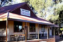 |
| 9/2/302/0063 | Somerlust, 32 Whites Road, Waverley, Bloemfontein | Type of site: Residence. | Bloemfontein, Waverley | Bloemfontein | Register | 29°05′25″S 26°13′40″E / 29.090152°S 26.227723°E |
|
| 9/2/302/0064 | Main Building, University of the Orange Free State, Bloemfontein | The cornerstone of this building with its neoclassical features was laid on 19 December 1907 by Sir Hamilton Goold-Adams. It was formally opened on 16 October 1909. The north and south wings date from 1915 and 1929, respectively. Type of site: Educational. The cornerstone of this building with its neoclassical features was laid on 19 December 1907 by Sir Hamilton Goold-Adams. It was formally opened on 16 October 1909. The north and south wings date from 1915 and 1929, respectively. | Bloemfontein, Universitas | Bloemfontein | Provincial Heritage Site | 29°06′38″S 26°11′11″E / 29.110660°S 26.186492°E |  |
| 9/2/302/0065 | Station Building, Sannaspos Railway Station, Bloemfontein District | The station building is a long building made of sandstone. It has a stand-up roof made of metal tile This railway station building of sandstone was completed shortly before the Anglo-Boer War (1899-1902). It is one of only a few station buildings erected during the Republican period and forms an important link with the Orange Free State railway system of Type of site: Railway Station Previous use: Other: Sannaspos Battlefield. This railway station building of sandstone was completed shortly before the Anglo-Boer War (1899-1902). It is one of only a few station buildings erected during the Republican period and forms an important link with the Orange Free State railway system of | Bloemfontein | Provincial Heritage Site | 29°09′39″S 26°32′50″E / 29.160828°S 26.547184°E |  | |
| 9/2/302/0077 | Green Lodge, 81 St Georges Street, Bloemfontein | The original core is considered the oldest building in Bloemfontein. The original portion of this dwelling dates from the 1840s and was built by Henry Green, Assistant Commissioner- General of the Orange River Sovereignty. The house was later occupied, amongst others; by the Rev. Andrew Murray, President M. T.Steyn’s father Type of site: Educational Previous use: Parsonage. Current use: Other: Education Centre. The original portion of this dwelling dates from the 1840s and was built by Henry Green, Assistant Commissioner-General of the Orange River Sovereignty. The house was later occupied, amongst others, by the Rev. Andrew Murray, President M.T. Steyn’s father | Bloemfontein | Bloemfontein | Provincial Heritage Site | 29°07′13″S 26°13′02″E / 29.120208°S 26.217162°E |
|
| 9/2/302/0078 | White Horse Stone, Naval Hill, Bloemfontein | 0 | Bloemfontein, Naval Hill | Bloemfontein | Provincial Heritage Site | 29°05′59″S 26°14′21″E / 29.09971°S 26.2391°E |
|
| 9/2/302/0079 | Abraham Fischer House, University of the Orange Free State, Bloemfontein | It is a double-storeyed building with a stand roof of orange-red tiles. It has three extensions. It was designed by Frank Taylor and officially opened in 1909-08-16 by Abraham Fischer. It was one o Architectural style: Cape-Holland. Type of site: House Current use: Hostel. | Bloemfontein, Universitas | Bloemfontein | Provincial Heritage Site | 29°06′42″S 26°11′10″E / 29.111767°S 26.185999°E |
|
| 9/2/303/0001 | Paardeberg Battlefield, Boshof District | Type of site: Battlefield. | Boshof | Provincial Heritage Site | 28°58′57″S 25°05′35″E / 28.982500°S 25.093056°E |
| |
| 9/2/303/0001/003 | British military cemetery, Vendusiedrift, Boshof District | Type of site: Cemetery Military. | Boshof | Provincial Heritage Site | 28°58′28″S 25°05′38″E / 28.974454°S 25.093964°E |
| |
| 9/2/303/0006 | Site where General De Villebois-Mareuil was killed, Middelkuil, Boshof District | In 1892 De Villebois-Mareuil was the youngest colonel in the French Army. With the outbreak of the An . | Boshof | Provincial Heritage Site | 28°40′00″S 25°17′30″E / 28.6666666666°S 25.2916666666°E |
| |
| 9/2/303/0009 | Town Hall, Voortrekker Street, Boshof | Single storey plastered brick building with gables and high pitched corrugated iron roof. Ventilators on roof ridge. Corrugated iron lean-to verandahs with decorative iron pillars on front façade. Timber doors with arched fanlights and steel windows. Needs investigation Type of site: Town Hall Current use: Town Hall. Forms part of town's history. | Boshof | Boshof | Register | 28°32′19″S 25°14′20″E / 28.538690°S 25.238951°E |
|
| 9/2/303/0011 | Powder Magazine, Town Commonage, Boshof | It is doleriet building with a low-pitched corrugated iron roof. It has an iron-and-timber door, a This powder magazine, which was designed by the architect D. E. Wentink in September 1898, is an oblong building that was built of local dolerite stone. It was presumably erected with a view to the impending Anglo-Boer War of 1899 to 1902. Type of site: Powder Magazine Previous use: Powder magazine. Current use: Other: none. This powder magazine, which was designed by the architect D. E. Wentink in September 1898, is an oblong building that was built of local dolerite stone. It was presumably erected with a view to the impending Anglo-Boer War of 1899 to 1902. | Boshof | Boshof | Provincial Heritage Site | 28°32′31″S 25°14′03″E / 28.542064°S 25.234056°E |
|
| 9/2/304/0001zz | Old police station and prison cells, President Street, Bothaville | Type of site: Prison, Police Station. | Bothaville | Bothaville | Register | 27°23′19″S 26°36′35″E / 27.388594°S 26.609673°E |
|
| 9/2/304/0002zz | Dutch Reformed Mother Church, President Street, Bothaville | This impressive cruciform church is built of sandstone. There is a tower in the middle of the front This impressive cruciform church was designed by the architect Gerard Moerdyk and built of sandstone by the contractors Marshalt and Maclntrosh. The corner-stone laid by Ds F. G. T. Radloff on 6 April 1918 and the church was officially inaugurated on 2 Ap Type of site: Church Previous use: Church. Current use: Church. This impressive cruciform church was designed by the architect Gerard Moerdyk and built of sandstone by the contractors Marshalt and Maclntrosh. The corner-stone waylaid by Ds F. G. T. Radloff on 6 April 1918 and the church was officially inaugurated on 2 | Bothaville | Bothaville | Provincial Heritage Site | 27°23′34″S 26°36′52″E / 27.392655°S 26.614352°E |  |
| 9/2/304/0003zz | Doornkraal Battlefield, Klipkraal, Bothaville District | Type of site: Battlefield. | Bothaville | Pending (Plaque) | 27°28′39″S 26°35′40″E / 27.477567°S 26.594460°E |  | |
| 9/2/304/0003zz | Concentration Camp Cemetery, Louvain 286, Brandfort District | Type of site: Concentration Camp Cemetery. cemetery contains the mortal remains of 1 263 women and children who died during the Anglo-Boer War | Brandfort | Provincial Heritage Site | 27°28′39″S 26°35′40″E / 27.477567°S 26.594460°E | 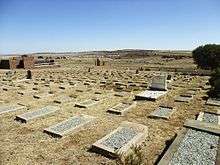 | |
| 9/2/304/0004zz | Town Hall, Preller Street, Bothaville | Face brick building under hipped corrugated iron roof. Plastered cornices and pilasters. Sandstone plinth and window sills. Timber and steel doors and steel windows. The cornerstone of the building was laid on 4 March 1950 by the mayor of Bothaville, Dr T Meyer. The building contractor was G Sacchettoni. Architectural style: Modern. Type of site: Town Hall Current use: Town Hall. The building which was designed by J P Hulshof and erected in 1950, has intrinsic aesthetic/architectural merit. | Bothaville | Bothaville | Register | 27°23′34″S 26°37′05″E / 27.39265°S 26.618077°E |
|
| 9/2/304/0006zz | Old Nederduitse Gereformeerde Church Parsonage, 66 President Street, Bothaville | Type of site: Parsonage. | Bothaville | Bothaville | Register | 27°23′28″S 26°36′47″E / 27.3912111111°S 26.613175°E |
|
| 9/2/306/0001-001 | Magistrates's Office, Voortrekker Street, Brandfort | Type of site: Magistrates Office. | Brandfort | Brandfort | Register | 28°42′05″S 26°28′00″E / 28.701308°S 26.466731°E |
|
| 9/2/306/0003 | Concentration Camp Cemetery, Louvain, Brandfort District | The cemetery is surrounded with an iron trellis on a stone wall. It has a slated floor. There is mar This cemetery contains the mortal remains of 1 263 women and children who died during the Anglo-Boer War (1899-1902) in the concentration camp at Brandfort. The cemetery, which was designed by J. du Toit, was officially opened on 22 September 1962 by Pres Type of site: Concentration Camp Cemetery Current use: Graveyard. This cemetery contains the mortal remains of 1 263 women and children who died during the Anglo-Boer War (1899-1902) in the concentration camp at Brandfort. The cemetery, which was designed by J. du Toit, was officially opened on 22 September 1962 by Pres | Brandfort | Provincial Heritage Site | 28°42′23″S 26°27′13″E / 28.706364°S 26.453737°E | | |
| 9/2/308/0004 | Farm House, Prynnsberg, Clocolan District | Type of site: Farm Complex. | Clocolan | Clocolan | Provisional Protection | 28°54′02″S 27°38′12″E / 28.900598°S 27.636741°E |
|
| 9/2/308/0005 | Town Hall, Andries Pretorius Street, Clocolan | Single storey sandstone building. Symmetrical front façade, ending in large Cape Dutch gable. Double pitched corrugated iron roof with ventilators on roof ridge. Sandstone extensions on side elevations with Cape Dutch gables. Timber doors and windows. The cornerstone of the building was laid on 15 November 1916 by the Mayor of Clocolan, Councillor T A Wilsenach. Type of site: Town Hall Current use: Town Hall. The building, which was erected in 1916-1917, is a fine example of a sandstone town hall. It contributes to the character of the street and is a landmark in town. | Clocolan | Clocolan | Register | 28°54′51″S 27°34′01″E / 28.914159°S 27.566884°E |
|
| 9/2/309/0004 | Town Hall, Voortrekker Street, Dewetsdorp | Single storey plastered brick building. Double pitched corrugated iron roof with decorative ventilator. Symmetrical front façade with triangular pediment, pilasters and gable. Extensions with corrugated iron roofs on side and rear of the building. The building was rebuilt in 1928 after the previous town hall was destroyed by fire. Type of site: Town Hall Current use: Town Hall. The building, which was erected in 1928, is a typical example of town hall built in the Free State. It contributes to the character of the area and is a landmark in the town. | Dewetsdorp | Dewetsdorp | Register | 29°35′01″S 26°39′55″E / 29.583543°S 26.665385°E |
|
| 9/2/309/0006 | St Bartholomew Anglican Church, 27 van der Wath Street, Dewetsdorp | Plastered brick building with pitched corrugated iron roof and triangular end gables. Black-painted Building-work on the church commenced on 18 August 1882. Four months later on 17 December the buildi Type of site: Church Current use: Church. This small plastered brick building, erected in 1882 is one of the oldest remaining Anglican Church buildings in the Free State. It serves as a fine example of the church buildings erected in the province during the previous century by the Anglican church | Dewetsdorp | Dewetsdorp | Register | 29°34′49″S 26°40′04″E / 29.580161°S 26.667858°E |
|
| 9/2/310/0002 | Church and School Buildings, Bethany Mission Complex, Edenburg District | Type of site: School Current use: Mission Complex. | Edenburg | Provisional Protection | 29°36′23″S 25°57′39″E / 29.606477°S 25.960849°E |
| |
| 9/2/310/0007 | Town Hall, Church Street, Edenburg | Single storey plastered brick building under pitched corrugated iron roof. Symmetrical front façade with Cape Dutch gables and arched openings with sandstone surrounds. Lean-to corrugated iron verandahs with sandstone pillars on front and side façades. The cornerstone of the building was laid on 25 October 1924 by E R Grobler, Administrator of the Orange Free State. Type of site: Town Hall Current use: Town Hall. The building, which was erected in 1924-1925, is a typical example of a town hall built in the Free State. It contributes to the character of the area and is a landmark in the town. | Edenburg | Edenburg | Register | 29°44′10″S 25°56′08″E / 29.736082°S 25.935528°E |  |
| 9/2/311/0001 | Old hostel, Tweespruit High School, Excelsior District | It is a rectangular sandstone building with a courtyard The front façade of the building has three b The interior of the building had changed very much over the years. In 1918 a part of the building was Type of site: School Previous use: Stables. Current use: Hostel. | Tweespruit | Excelsior | Provincial Heritage Site | 29°11′44″S 27°04′12″E / 29.195629°S 27.069945°E |  |
| 9/2/311/0002 | Old Farmhouse, Merumetsu, Excelsior District | Type of site: Farm. | Excelsior | Register | 28°27′22″S 26°47′53″E / 28.456223°S 26.797987°E |
| |
| 9/2/312/0001 | Old Powder Magazine, Luckhoff, Fauresmith District | This powder magazine is built of dolerite stone and has a low corrugated iron roof. The door is made This powder magazine, which was erected during the first half of 1899, is a rectangular structure that was built from local dolerite stone. It was presumably erected with a view to the impending Anglo-Boer War (1899-1902) Type of site: Powder Magazine Previous use: Powder Magazine. This powder magazine, which was erected during the first half of 1899, is a rectangular structure that was built from local dolerite stone. It was presumably erected with a view to the impending Anglo-Boer War (1899-1902). | Fauresmith | Provincial Heritage Site | 29°45′09″S 24°47′12″E / 29.752609°S 24.786779°E |
| |
| 9/2/312/0002 | Old Prison, West End Street, Fauresmith | Type of site: Gaol. | Fauresmith | Fauresmith | Provincial Heritage Site | 29°44′43″S 25°18′38″E / 29.745368°S 25.310614°E |
|
| 9/2/312/0003 | Standard Bank, Voortrekker and Van Riebeeck Streets, Fauresmith | The building is a single storey building that consist out of three entities. Floors are generally of The Volksraad prohibited the existence of any bank in the Free State, except those condoned by Legis Architectural style: Late Republican. Type of site: Bank Current use: Bank. | Fauresmith | Fauresmith | Provincial Heritage Site | 29°44′55″S 25°19′00″E / 29.748713°S 25.316550°E |
|
| 9/2/312/0005 | Town Hall, Voortrekker Street, Fauresmith | Single storey plastered brick building under pitched corrugated iron roof. Symmetrical front façade with tower, triangular pediment and pilasters. Extensions on side elevations with lean-to corrugated iron verandahs. Timber doors and windows. The building was completed in June 1930 after the previous town hall was destroyed by fire in 1927. It was officially opened by the Administrator of the Orange Free State, C T M Willcocks and the Mayor of Fauresmith, Dr J J van Niekerk. Type of site: Town Hall Current use: Town Hall. The building, which was erected in 1930, is a typical example of a town hall built in the Free State. It contributes to the character of the area and is a landmark in the town. | Fauresmith | Fauresmith | Register | 29°44′39″S 25°18′35″E / 29.744269°S 25.309622°E |
|
| 9/2/312/0006-001 | 12 East Burger Street, Fauresmith | 0 | Fauresmith | Fauresmith | Register | 29°44′59″S 25°19′01″E / 29.749819°S 25.316899°E |
|
| 9/2/312/0007 | Post Office, 25 Voortrekker Street, Fauresmith | Type of site: Post Office. | Fauresmith | Fauresmith | Register | 29°44′58″S 25°19′10″E / 29.7494138888°S 25.3195361111°E |
|
| 9/2/313/0008 | 81 McCabe Street, Ficksburg | The house which was erected in 1885 is probably one of the oldest remaining dwellings in Ficksburg. Many of the original elements of the building, such as the sliding sash windows, quoining around the doors and windows, timber floors, fire-places and fou | Ficksburg | Ficksburg | Register | 28°52′12″S 27°52′26″E / 28.8700833333°S 27.8738916666°E |
|
| 9/2/313/0010 | General Fick Museum, Old Market Square, Ficksburg | This building has a red pitched corrugated iron roof and walls of sandstone. It has wood doors. The building was completed in 1893 and a fine example of the magistrate's offices to be erected in t Type of site: Civic Previous use: Office's. Current use: Museum. This sandstone building, completed in 1893, is a fine example of the magistrate offices erected in the Orange Free State during the Late Republican period. This building together with the adjacent town hall and old post office form an attractive architecture | Ficksburg | Ficksburg | Provincial Heritage Site | 28°52′19″S 27°52′30″E / 28.872062°S 27.874954°E |
|
| 9/2/313/0011 | Town Hall, Old Market Square, Ficksburg | Single storey sandstone building. Double pitched corrugated iron roof with ventilators. Symmetrical front façade with decorative gable. Extensions on side elevations with lean-to corrugated iron verandahs in between. Timber doors and steel windows. The cornerstone of the building was laid on 21 July 1897 by the Chairman of the Municipality of Ficksburg, Mr M I Fourie. It was completed before the outbreak of the Anglo-Boer War. Architectural style: Neo-Classical. Type of site: Town Hall Current use: Town Hall. This sandstone building with its Neo-Classical features was designed by Walter Donaldson and completed during the 1890s. The town hall, adjacent museum building and old post office form one of the finest sandstone building groups in the Free State. | Ficksburg | Ficksburg | Provincial Heritage Site | 28°52′19″S 27°52′29″E / 28.871877°S 27.874598°E |
|
| 9/2/313/0012 | Nederduitse Gereformeerde Mother Church, Voortrekker Street, Ficksburg | It is a sandstone building with a corrugated iron roof. It has six louvre ventilators. The building. In 1903 J.D. Kestell was confirmed the new minister. The cornerstone was laid by Ds. J.D. Kestell in. Type of site: Church. Current use: Church. | Ficksburg | Ficksburg | Provincial Heritage Site | 28°52′26″S 27°52′41″E / 28.873880°S 27.878049°E |
|
| 9/2/313/0013 | Old Prison-cells, Brand Street, Ficksburg | It is a single-storey rectangular sandstone building with a flat corrugated iron roof. It has two ti. This building originally formed part of a prison which was erected in 1893. Mr C.R. Swart, first pre. Type of site: Gaol. Previous use: Prison-cells. | Ficksburg | Ficksburg | Provincial Heritage Site | 28°52′12″S 27°52′42″E / 28.869873°S 27.878262°E |
|
| 9/2/314/0001 | Surrender Hill, Amsterdam, Fouriesburg District | 0 | Fouriesburg | Provincial Heritage Site | 28°36′30″S 28°23′00″E / 28.6083333333°S 28.3833333333°E |
| |
| 9/2/314/0006 | Nederduitse Gereformeerde Church, Church Square, Fouriesburg | Type of site: Church | Fouriesburg | Fouriesburg | Provincial Heritage Site | 28°37′20″S 28°12′24″E / 28.622145°S 28.206781°E |
|
| 9/2/314/0007 | Town Hall, Martin Street, Fouriesburg | Single-storey sandstone building under hipped corrugated iron roof. Cape Dutch gables on front and side elevations. Timber doors and casement windows, timber floors and pressed steel ceilings. The cornerstone of the building was laid on 8 September 1926 by J H Meiring. The building contractor was Thomas Drummond. Type of site: Town hall. Current use: Town hall. The building, which was erected in 1926, is a fine example of sandstone town hall, built in the Free State. It contributes to the character of the area and is a landmark in the town. | Fouriesburg | Fouriesburg | Register | 28°37′14″S 28°12′29″E / 28.620521°S 28.208138°E |
|
| 9/2/315/0001 | Post Office, Van Reenen Street, Frankfort | Type of site: Post office | Frankfort | Frankfort | Provincial Heritage Site | 27°16′39″S 28°29′32″E / 27.277434°S 28.492114°E |  |
| 9/2/315/0002 | Police Station, Van Reenen Street, Frankfort | Type of site: Police station | Frankfort | Frankfort | Provincial Heritage Site | 27°16′36″S 28°29′32″E / 27.276696°S 28.492231°E |
|
| 9/2/315/0003 | Old Magistrate's Court, Van Reenen Street, Frankfort | Type of site: Courthouse. | Frankfort | Frankfort | Provincial Heritage Site | 27°16′36″S 28°29′32″E / 27.276536°S 28.492260°E |
|
| 9/2/316/0001 | Farmhouse, Klerksvlei, Harrismith District | It is H-form single storey sandstone building with a black painted corrugated iron roof. There is a s The building were erected in 1884. It is one of the few farmsteads that wasn't burnt during the Angl Type of site: Farm Complex Current use: House. | Harrismith | Provincial Heritage Site | 28°17′00″S 29°08′00″E / 28.283333°S 29.133333°E |
| |
| 9/2/316/0002 | British Regimental Badges, Harrismith | 0 | Harrismith | Harrismith | Provincial Heritage Site |  | |
| 9/2/316/0003 | 36A Boys Street, Harrismith | 0 | Harrismith | Harrismith | Register | 29°07′50″S 28°16′22″E / 29.1306333333°S 28.2726472222°E |
|
| 9/2/316/0004 | Badenhorst Building, Warden Street, Harrismith | 0 | Harrismith | Harrismith | Register | 28°16′32″S 29°07′49″E / 28.275490°S 29.130233°E |
|
| 9/2/316/0005 | A E Odell Building, Stuart Street, Harrismith | 0 | Harrismith | Harrismith | Register | 28°16′19″S 29°07′46″E / 28.271887°S 29.129372°E |
|
| 9/2/316/0011 | Swalu Bridge, Landdrost, Harrismith District | It is build out of sandstone. Robert Macfarlane laid the corner stone of the bridge on 04-11-1883. The toll-bridge was completed i Type of site: Bridge Current use: Bridge. | Harrismith | Provincial Heritage Site | 28°15′54″S 29°02′39″E / 28.265014°S 29.044273°E |
| |
| 9/2/316/0014 | Retiefklip, Kerkenberg, Harrismith District | Thirty km south of Harrismith the road to Bergville descends the Drakensberg escarpment by the steep Oliviershoek Pass. Near the top of the pass a secondary road turns off to the left and, after crossing the Oude bergspruit, ascends a steep rough slope to . | Harrismith | Provincial Heritage Site | 28°30′16″S 29°06′53″E / 28.504315°S 29.114842°E |  | |
| 9/2/316/0016 | Anglo-Boer War Blockhouse, Drakensberg Botanical Garden, Harrismith | This Anglo-Boer War blockhouse is situated on the town commonage of Harrismith, to the north-east of the town.
In 1901 the British military authorities built a formidable system of blockhouses in the north-eastern Orange Free State. One of the lines of th Type of site: Blockhouse. |
Harrismith | Harrismith | Provincial Heritage Site | 28°16′58″S 29°09′39″E / 28.282688°S 29.160841°E |  |
| 9/2/316/0020 | Nederduitse Gereformeerde Church, Church Street, Warden, Harrismith District | This impressive building with its 44 metre high clock- tower was designed by the architect F. Heesse and erected with the assistance of members of the congregation. The corner-stone of the building was laid on 7 February 1920 and the church was officially Type of site: Church. This impressive building with its 44 metre high clock- tower was designed by the architect F. Heesse and erected with the assistance of members of the congregation. The corner-stone of the building was laid on 7 February 1920 and the church was officially | Warden | Harrismith | Provincial Heritage Site | 27°51′33″S 28°57′44″E / 27.859289°S 28.962226°E |  |
| 9/2/316/0023 | Town Hall, Warden Street, Harrismith | Double storey red brick building with centrally placed tower and decorative sandstone detail, including sandstone portico on front façade. Timber doors and windows. Market hall at rear of building with corrugated iron roof and verandah. The building was erected by the builders Kelly and Anderson of Johannesburg. The cornerstone was laid on 2 August 1907 by Sir Hamilton Goold-Adams, Lieutenant-Governor of the Orange River Colony. The building was officially inaugurated on 7 September 1908. Architectural style: Neo-classical. Type of site: Town Hall Current use: Town Hall. This red brick building with its sandstone ornamentation was designed by Price and Agutter and erected in 1907-1908. It is one of the most impressive town halls in the Free State and a landmark in Harrismith. | Harrismith | Harrismith | Provincial Heritage Site | 28°16′13″S 29°07′28″E / 28.270211°S 29.124514°E |  |
| 9/2/316/0024 | Old Toll-bridge, Wilge River, Swinburne, Harrismith District | It is composed of three arches of thirty-three feet four inches, and carries a roadway of eight feet This toll-bridge was one of the first for the Free State. The bridge was built to facilitate the tra Type of site: Toll Current use: Bridge. | Harrismith | Harrismith | Provincial Heritage Site | 28°21′07″S 29°16′49″E / 28.351962°S 29.280211°E |
|
| 9/2/317/0001 | Weilbach House, Leeuwpoort, Heilbron District | It is a single storey rectangular sandstone building with a pitched corrugated iron roof a two metre The house was built by a Scot named Sharpe for J.F. Weilbach and his wife. This building and nearb Architectural style: Late Republican. Type of site: House Current use: House. | Heilbron | Provincial Heritage Site | 27°13′30″S 27°56′00″E / 27.225°S 27.9333333333°E |
| |
| 9/2/317/0002 | Vegkop Battlefield, Heilbron District | The area is an open terrace with an entrance gate and inside is a monument situated on rocks. On the left of the Lindley road, twenty kilometres south of Heilbron, one sees a long, narrow ridge. This is the famous Vegkop on the farm officially named Vechtkop Oost, where the Voortrekkers were attacked by a strong Matabele force in October, 1836.
Th Type of site: Battlefield Previous use: Battlefield. Current use: Monument. |
Heilbron | Provincial Heritage Site | 27°28′41″S 27°54′49″E / 27.478028°S 27.913524°E |  | |
| 9/2/317/0003 | Old farmhouse, Leeuwpoort, Heilbron District | Type of site: Farmhouse Current use: House. | Heilbron | Provincial Heritage Site | 27°13′30″S 27°56′00″E / 27.225°S 27.9333333333°E |
| |
| 9/2/317/0004 | Railway station, Heilbron | It is a single storey, rectangular sandstone building with a pitched corrugated iron roof. The building was erected in 1898. Formerly the railway between Bethelehem and Heilbron were finis Architectural style: Republican. Type of site: Railway Station Current use: Railway station. | Heilbron | Heilbron | Provincial Heritage Site | 27°17′24″S 27°57′54″E / 27.290118°S 27.964969°E |  |
| 9/2/318/0001 | Farmhouse, Ferreirasrust, Hennenman District | It is a single storey sandstone building with a pitched corrugated iron roof. The building has a cor In the 1890s the house was built for Thomas Minter, owner of the Kaal Valley mine. The house is Architectural style: Late Republican. Type of site: Farm Complex Current use: House. | Hennenman | Provincial Heritage Site | 27°58′42″S 27°01′35″E / 27.978392°S 27.026445°E |
| |
| 9/2/319/0001 | Dutch Reformed Church, Church Street, Hoopstad | It is an impressive cruciform church and has neo-gothic features. The church is built of sandstone. The comer-stone of this impressive cruciform church with its Neo-Gothic features was laid by President F. W. Reitz on 6 June 1891. The building was officially inaugurated on 2 December 1892. Architectural style: Neo-Gothic. Type of site: Church Current use: Church. The corner-stone of this impressive cruciform church with its Neo-Gothic features was laid by President F. W. Reitz on 6 June 1891. The building was officially inaugurated on 2 December 1892. | Hoopstad | Hoopstad | Provincial Heritage Site | 27°50′05″S 25°54′12″E / 27.834780°S 25.903310°E |  |
| 9/2/320/0002 | Burgher Memorial, Magersfontein, Jacobsdal District | Type of site: Memorial. | Jacobsdal | Provincial Heritage Site | 28°59′03″S 24°42′30″E / 28.984250°S 24.708424°E |
| |
| 9/2/320/0008 | Nederduitse Gereformeerde Church, Andries Pretorius Street, Jacobsdal | It is a white cross church with a corrugated iron roof and a tower in the middle of the front gable. The original part of this impressive cruciform church dates from 1879. The corner-stone was laid on 29 January 1878 and the building was completed on 29 July 1879. The original building was changed to its present cross shape by the addition in 1929 and 19 Type of site: Church Previous use: Church. Current use: Church. The original part of this impressive cruciform church dates from 1879. The corner-stone was laid on 29 January 1878 and the building was completed on 29 July 1879. The original building was changed to its present cross shape by the addition in 1929 and 19 | Jacobsdal | Jacobsdal | Provincial Heritage Site | 29°07′44″S 24°46′25″E / 29.128780°S 24.773608°E |
|
| 9/2/320/0010 | Anglo-Boer War Blockhouse, Jacobsdal | The blockhouse was built of dolerite stone and has a low pitched corrugated iron roof. The building This blockhouse, which dates from 1901, was built of dolerite stone. During the Anglo-Boer War (1899-1902) it formed part of a line of similar blockhouses that was erected to protect the road link between the two railway lines that ran through Kimberley a Type of site: Blockhouse Previous use: Fortification. Current use: Vacant. This blockhouse, which dates from 1901, was built of dolerite stone. During the Anglo-Boer War (1899-1902) it formed part of a line of similar blockhouses that was erected to protect the road link between the two railway lines that ran through Kimberley a | Jacobsdal | Jacobsdal | Provincial Heritage Site | 29°07′43″S 24°46′38″E / 29.128746°S 24.777094°E |
|
| 9/2/321/0001 | Water-pumps, Jagersfontein | It is pumps that that is standing out one metre above the ground. At the top it has the head of a li These 18 water-pumps formed part of the water supply scheme that the firm Stewarts and Lloyds installed for Jager in 1913. The pumps offered a unique solution to the water supply problem that was experienced earlier in many rural towns. Type of site: Water Pump Previous use: Other: Water-pumps. Current use: Other: Water-pumps. These 18 water-pumps formed part of the water supply scheme that the firm Stewarts and Lloyds installed for Jagersfontein in 1913. The pumps offered a unique solution to the water supply problem that was experienced earlier in many rural towns. | Jagersfontein | Jagersfontein | Provincial Heritage Site | 29°45′44″S 25°25′31″E / 29.762113°S 25.425239°E |
|
| 9/2/321/0003 | Town Hall, Market Square, Jagersfontein | Single storey pained brick building under double pitched corrugated iron roof with ventilators. Timber doors, windows and flors. The building was erected after the previous city hall was destroyed by fire. Type of site: Town Hall Current use: Town Hall. The building, which was erected in 1913, forms part of an important group of buildings which face on to the town square. It contributes to the character of the area and is a landmark in the town. | Jagersfontein | Jagersfontein | Register | 29°46′00″S 25°26′07″E / 29.766717°S 25.435175°E |
|
| 9/2/322/0002 | Lutheran Church complex, Adamshoop, Oppermangronde, Koffiefontein District | Type of site: Church Complex. | Koffiefontein | Provincial Heritage Site | 29°24′41″S 24°44′38″E / 29.411350°S 24.743759°E |
| |
| 9/2/323/0002 | Vredefort Road Concentration Camp Cemetery, Prospect, Koppies District | Some graves in the cemetery is not readable. In the middle of the graves is a monument made of sands This cemetery contains the mortal remains of approximately 800 women and children who died during the Anglo Boer War (1899-1902) in the Vredefort Road Concentration Camp. Type of site: Concentration Camp Cemetery Current use: Cemetery. This cemetery contains the mortal remains of approximately 800 women and children who died during the Anglo Boer War (1899-1902) in the Vredefort Road Concentration Camp. | Koppies | Provincial Heritage Site | 27°09′08″S 27°39′12″E / 27.152156°S 27.653339°E |
| |
| 9/2/324/0001 | Farmhouse, Congleton, Kroonstad District | Type of site: Farm Complex. | Kroonstad | Kroonstad | Register | 27°39′00″S 27°14′00″E / 27.650000°S 27.233333°E |
|
| 9/2/324/0003 | Kroonstad North Nederduitse Gereformeerde Church, Reitz, Symond and Malherbe Streets, Kroonstad | Type of site: Church. | Kroonstad | Kroonstad | Register | 27°39′00″S 27°14′00″E / 27.650000°S 27.233333°E |  |
| 9/2/324/0005 | Old Market Square Post Office and prison-cells, 66 Murray Street, Kroonstad | Type of site: Post Office, Gaol. | Kroonstad | Kroonstad | Provincial Heritage Site | 27°40′11″S 27°14′04″E / 27.6698138888°S 27.2345222222°E |
|
| 9/2/324/0006 | Old market building, Market and Murray Streets, Kroonstad | The building is built in a Victorian-style. It has steel gates between the iron pillars. It has no w This building with its Victorian features was presumably erected in the late 19th or early 20th centuries. The steel gates between the iron pillars were added in 1960. The building forms an integral part of the historic market-square of Kroonstad. Architectural style: Victorian. Type of site: Commercial Current use: Market. This building with its Victorian features was presumably erected in the late 19th or early 20th centuries. The steel gates between the iron pillars were added in 1960. The building forms an integral part of the historic market-square of Kroonstad. | Kroonstad | Kroonstad | Provincial Heritage Site | 27°40′10″S 27°14′03″E / 27.669552°S 27.234176°E |
|
| 9/2/324/0008 | Town Hall, Church Street, Kroonstad | Sandstone building under hipped corrugated iron roof with bell-tower and louvred ventilators. Front façade with two decorative towers, sandstone portico and pediment. Sliding sash windows and timber doors with fanlights. The cornerstone of the building was laid on 14 March 1906 by the Mayor of Kroonstad, T W Hoseason. Building operations were started by B W Eastwood and Morris & Lightbody and completed by Rowe & Marshall. Architectural style: Neo-Classical. Type of site: Town Hall Current use: Town Hall. The sandstone building with its Neo-Classical features was designed by J H & A E Till. It was officially opened on 7 June 1907 by Sir Hamilton Goold-Adams, Lieutenant-Governor of the Orange River Colony. It forms part of an important architectural group a | Kroonstad | Kroonstad | Provincial Heritage Site | 27°40′05″S 27°14′07″E / 27.668024°S 27.235338°E |  |
| 9/2/324/0013 | Corrugated iron house, Wessels Street, Edenville, Kroonstad District | Type of site: House. | Edenville | Kroonstad | Provisional Protection | 27°33′10″S 27°40′22″E / 27.552784°S 27.672652°E |
|
| 9/2/324/0014 | Old Magistrate's Office, Murray Street, Kroonstad | Type of site: Magistrates Office. | Kroonstad | Kroonstad | Provincial Heritage Site | 27°40′09″S 27°14′03″E / 27.669110°S 27.234048°E |
|
| 9/2/324/0016 | Nederduitse Gereformeerde Mother Church, Church Square, Kroonstad | It is a sandstone building with a corrugated iron roof. On the roof there is a dome. On the one corn The building was designed by W.H. Ford and completed in 1914. After the Anglo Boer War money was sc Type of site: Church Current use: Church. | Kroonstad | Kroonstad | Provincial Heritage Site | 27°39′28″S 27°14′43″E / 27.657858°S 27.245289°E |  |
| 9/2/325/0001 | Mill building, Leeuw Rivers Drift, Ladybrand District | Type of site: Commercial. | Ladybrand | Provisional Protection | 29°15′30″S 27°12′20″E / 29.2583333333°S 27.2055555555°E |
| |
| 9/2/325/0002 | Sandstone school building, Coenraad Snyman Primary School, Modderpoort, Ladybrand District | Type of site: School. | Ladybrand | Register | 28°27′15″S 26°47′48″E / 28.454111°S 26.796785°E |
| |
| 9/2/325/0004 | Old Magistrate's Court, Piet Retief Street, Ladybrand | Type of site: Courthouse. | Ladybrand | Ladybrand | Provincial Heritage Site | 29°11′51″S 27°27′35″E / 29.197475°S 27.459828°E |
|
| 9/2/325/0005 | Police Station, Piet Retief Street, Ladybrand | Type of site: Police Station. | Ladybrand | Ladybrand | Provincial Heritage Site | 29°11′44″S 27°27′23″E / 29.195629°S 27.456516°E |
|
| 9/2/325/0007 | St James Anglican Church, Joubert Street, Ladybrand | Sandstone building with sandstone buttresses under high-pitched corrugated iron roof. Sandstone apse The building was erected to serve as a memorial for the late Father James Douglas, who wished for a Architectural style: Neo-Gothic. Type of site: Church Current use: Church. This church was designed by John Edwin Harrison. | Ladybrand | Ladybrand | Provincial Heritage Site | 29°11′53″S 27°27′18″E / 29.198131°S 27.454908°E |
|
| 9/2/325/0016 | Town Hall, Dan Pienaar and Joubert Streets, Ladybrand | Single storey sandstone building under corrugated iron roof with louvred ventilators and sandstone chimneys. Sandstone tower and portico in middle of symmetrical front façade. Steel windows and timber doors. Sandstone market building added on at rear. The cornerstone of the building was laid on 11 March 1931 by the Mayor of Ladybrand, J N van Soelen. The building contractor was V Daugaard. The market building at the rear was completed in 1933. Type of site: Town Hall Current use: Town Hall. The building was designed by the architect, F W Masey, and officially opened on 27 January 1932. It is a fine example of a sandstone town hall in the Free State and a landmark in the town. | Ladybrand | Ladybrand | Register | 29°11′37″S 27°27′27″E / 29.193715°S 27.457595°E |
|
| 9/2/325/0017 | Main building and school hall, Ladybrand High School, Collin Street, Ladybrand | The main building is a single storey sandstone building with a modern corrugated iron roof. The wood This school is a landmark in Ladybrand. The corner stone was laid on 1904-03-16 by Hugh Gunn, Direct Architectural style: Edwardian. Type of site: School Previous use: School. Current use: School. | Ladybrand | Ladybrand | Provincial Heritage Site | 29°11′59″S 27°27′04″E / 29.199802°S 27.451146°E |
|
| 9/2/325/0021 | 19 Prinsloo Street, Ladybrand | Rectangular Edwardian gentleman's residence. The fret- work on the verandah edge, together with the This Edwardian house of local Ladybrand sandstone is representative of the sandstone architecture wh Architectural style: Edwardian. Type of site: House Current use: Residential. | Ladybrand | Ladybrand | Provincial Heritage Site | 27°27′16″S 29°11′45″E / 27.4545638888°S 29.1958166666°E |
|
| 9/2/326/0003 | Beehive Stone Huts Sedan Lindley District | A group of Pre-historic stone huts at Lindley in the Province of the Orange Free State. The figure D.A.B.C. represents 3.0815 morgen of ground, being servitude No 1 on subdivision 1 of the farm Sedan No 133, Situated in the District of Lindley, Province of the Orange Free State, as indicated on Diagram SG No 37/1950 dated 14 February 1950 | Lindley | Provincial Heritage Site | 27°53′49″S 27°47′25″E / 27.896934°S 27.790416°EBeehive Stone Huts Sedan Lindley District) |
| |
| 9/2/326/0004 | Old Nederduitse Gereformeerde Church Parsonage, 33 Du Plessis Street, Petrus Steyn, Lindley District | It is a single storey sandstone building with a red painted corrugated iron roof. A part of the stoe The congregation were established in 1914. The services were held in the town-hall since there were Type of site: Parsonage Current use: House. | Petrus Steyn | Lindley | Provincial Heritage Site | 27°39′02″S 28°08′01″E / 27.650491°S 28.133535°E |
|
| 9/2/326/0005 | Town Hall, Church Street, Lindley | Single storey sandstone building under hipped corrugated iron roof with louvred ventilators. Triangular sandstone gables. Arched entrances to enclosed sandstone stoep on two sides of the building. The original part of the building was officially opened on 7 December 1911 by the Mayor of Lindley, S A Lange. The builder was P G J Koornhof. The new addition, built by E Hern, was opened on 7 September 1937 by the Administrator of the Orange Free State, Type of site: Town Hall Current use: Town Hall. The original portion of the building, erected in 1911, and the later addition of 1937 was designed by the well-known architect, H G E de la Cornillere. The building is a fine example of a sandstone town hall and a landmark in the town. | Lindley | Lindley | Register | 27°54′03″S 27°54′47″E / 27.900881°S 27.913183°E |
|
| 9/2/326/0013 | Town Hall, cnr Steyn and Van Riebeeck Streets, Steynsrus, Lindley District | Single storey plastered brick building under hipped corrugated iron roof. Gables on front and rear elevations. Projecting bay on front façade with triangular pediment and pilasters. Brick plinth. Steel doors and windows. Type of site: Town Hall Current use: Town Hall. The building, which was erected in 1929, is a fine example of a town hall, built in the Free State and a landmark in the town. | Steynsrus | Lindley | Register | 27°57′10″S 27°33′49″E / 27.952700°S 27.563590°E |
|
| 9/2/328/0001 | Prospecting bore-hole, Aandenk, Odendaalsrus District | This borehole on the farm Aandenk is 400 feet deep and in extent 4,301 square feet. The monument in One of the national roads from Bloemfontein passes through Brandfort and Theunissen to Welkom, Odendaalsrus and Allanridge in the Orange Free State Gold- fields. Where the road swings suddenly to the right near a large mine dump just south of Allanridge t Type of site: Mine Previous use: Mining. Current use: Mining. | Odendaalsrus | Provincial Heritage Site | 27°46′00″S 26°38′38″E / 27.766541°S 26.643970°E |  | |
| 9/2/329/0004 | Old magistrate's office, Liebenbergtrek Street, Parys | Single storey red brick building with a red pitched iron roof. Upon the roof there are two chimneys The building was erected during 1899-1900 when the Free State was under British control. In 1907, the Architectural style: Edwardian. Type of site: Magistrates Office Previous use: Magistrates Court. Current use: Museum. | Parys | Parys | Provincial Heritage Site | 26°54′01″S 27°27′25″E / 26.900374°S 27.456984°E |  |
| 9/2/329/0007 | Nederduitse Gereformeerde Mother Church, Hefer Street, Parys | The cruciform church has Neo-Gothic features. It has a Tower in the middle of the front gable and at the corner-stone of this cruciform church with its Neo Gothic features was laid by the Moderator of the Orange Free State Synod, the Rev. I. J. T. Marquard, on 14 January 1899. The building was completed shortly after the outbreak of the Anglo-Boer War (1 Architectural style: Neo-Gothic. Type of site: Church Current use: Church. The corner-stone of this cruciform church with its Neo- Gothic features was laid by the Moderator of the Orange Free State Synod, the Rev. J. J. T. Marquard, on 14 January 1899. The building was completed shortly after the outbreak of the Anglo-Boer War ( | Parys | Parys | Provincial Heritage Site | 26°54′03″S 27°27′21″E / 26.900865°S 27.455870°E |  |
| 9/2/330/0003 | Lutheran Church, Katdoornput, Petrusburg District | Type of site: Church. This simple church building with its Gothic features was designed and erected in 1897 by missionaries of the Berlin Mission Society at Bethany. It is one of only a few mission churches which remain in the Free State. As such it is one of the few tangibl | Petrusburg | Provisional Protection | 29°00′54″S 25°29′17″E / 29.014956°S 25.488099°E |
| |
| 9/2/331/0001 | 7 Colin Fraser Street, Philippolis | Architectural style: Victorian. Type of site: House Current use: House. The wagon-house forms an instrinsic part of the property, already declared a national monument. The property was the family home of Christiaan van der Post who played an important role in the political history of the Free State. It is also the birthplac | Philippolis | Philippolis | Provincial Heritage Site | 30°15′51″S 25°16′30″E / 30.264164°S 25.274992°E | 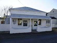 |
| 9/2/331/0002 | Powder magazine, Philippolis | Type of site: Powder Magazine Current use: Unused. | Philippolis | Philippolis | Provincial Heritage Site | 30°15′52″S 25°16′26″E / 30.264355°S 25.273949°E |
|
| 9/2/331/0003 | 4 Justisie Street, Philippolis | Single storeyed Karoo-house with flat corrugated iron roof behind front parapet wall with moulded co Architectural style: Karoo. Type of site: House Current use: House. Fairly unchanged example of a typical Karoo-house which is the most characteristic building type of | Philippolis | Philippolis | Provincial Heritage Site | 30°15′44″S 25°16′18″E / 30.262165°S 25.271544°E |  |
| 9/2/331/0004 | Old Pound, Justisie Street, Philippolis | Two adjacent stone-walled rectilinear kraals with cement pointing. Within one kraal is a small ston Architectural style: Vernacular. Type of site: Pound Previous use: Other: pound. Current use: Vacant. One of only two known remaining pounds in the Orange Free State. Forms an important part of the hist | Philippolis | Philippolis | Provincial Heritage Site | 30°15′40″S 25°16′16″E / 30.261093°S 25.271222°E |  |
| 9/2/331/0007-035 | 27 Tobie Muller Street, Philippolis | Modern single storeyed plastered brick house under pitched corrugated iron roof with face brick colu Architectural style: Modern. Type of site: House Current use: House. Detracts from character of traditional street scape. | Philippolis | Philippolis | Provincial Heritage Site | 30°16′00″S 25°16′24″E / 30.266596°S 25.273376°E |
|
| 9/2/331/0007-074 | 16 Tobie Muller Street, Philippolis | Single storeyed plastered brick Karoo house. Flat corrugated iron roof behind front parapet with mou This dwelling-house is a fine example of the flat-roofed type which from the late fifties of the nineteenth century replaced the houses with steep thatched roofs in the Orange Free State and which represents the most characteristic building type of the ea Architectural style: Victorian. Type of site: House Previous use: House. Current use: Vacant. This dwelling-house is a fine example of the flat-roofed type which from the late fifties of the nineteenth century replaced the houses with steep thatched roofs in the Orange Free State and which represents the most characteristic building type of the ea | Philippolis | Philippolis | Provincial Heritage Site | 30°15′56″S 25°16′24″E / 30.265517°S 25.273275°E |
|
| 9/2/331/0009 | 24 Tobie Muller Street, Philippolis | Single storeyed rough-cast plastered brick Karoo house. Flat corrugated iron roof behind front parap This dwelling-house is a fine example of the flat-roofed type which from the late fifties of the nineteenth century replaced the houses with steep thatched roofs in the Orange Free State and which represents the most characteristic building type of the ea Architectural style: Karoo-style. Type of site: House Current use: House. Important example of Karoo architecture with fine details. Forms part of traditional Tobie Muller St | Philippolis | Philippolis | Provincial Heritage Site | 30°16′00″S 25°16′24″E / 30.266596°S 25.273376°E |  |
| 9/2/331/0010 | 26 Kok Street, Philippolis | This property appears to consist of two houses of two different styles. One is an example of a flat This dwelling-house is a fine example of the flat-roofed type which from the late fifties of the nineteenth century replaced the houses with steep thatched roofs in the Orange Free State and which represents the most characteristic building type of the ea Architectural style: Karoo Victorian. Type of site: House Current use: House. This dwelling-house is a fine example of the flat-roofed type which from the late fifties of the nineteenth century replaced the houses with steep thatched roofs in the Orange Free State and which represents the most characteristic building type of the ea | Philippolis | Philippolis | Provincial Heritage Site | 30°15′58″S 25°16′26″E / 30.266045°S 25.274026°E |
|
| 9/2/331/0012 | Nederduitse Gereformeerde Church, Voortrekker Street, Philippolis | The picturesque town of Philippolis lies amongst typical stony hills some 28 kilometres north of the Orange River. It has a long history, for it was here that the Griquas under Adam Kok settled in 1825 at the insistence of Dr. John Philip. In time a villa Type of site: Church Previous use: Church. Current use: Church. On this ground stood originally the Griqua missionary church. On 08-05-1869, the corner-stone of this church was laid. This church was inaugurated in 1869 and is a fine example of nineteenth-century ecclesiastical architecture in South Africa. | Philippolis | Philippolis | Provincial Heritage Site | 30°15′42″S 25°16′22″E / 30.261607°S 25.272908°E |  |
| 9/2/331/0013 | Jacobson Museum and Library, 34 Voortrekker Street, Philippolis | Single storey plastered brick building with a high pitched corrugated iron roof and This imposing building, with its predominantly Victorian features, dates from 1905/6. Moritz Jacobson, bought the property in 1921 and lived there until 1977, when he donated it to the Municipality of Philippolis to be used as a library. In 1978 it was ta Architectural style: Victorian. Type of site: Library, Museum Previous use: House. Current use: Library and Museum. This imposing building, with its predominantly Victorian features, dates from 1905/6. Moritz Jacobson, bought the property in 1921 and lived there until 1977, when he donated it to the Municipality of Philippolis to be used as a library. In 1978 it was ta | Philippolis | Philippolis | Provincial Heritage Site | 30°15′45″S 25°16′23″E / 30.262489°S 25.273088°E |  |
| 9/2/332/0001 | 21 Boshoff Street, Reddersburg | Type of site: House. | Reddersburg | Reddersburg | Register | 29°39′13″S 26°10′23″E / 29.6535916666°S 26.1731194444°E |
|
| 9/2/332/0002 | Old nursing home, 11 Oranje Street, Reddersburg | 0 | Reddersburg | Reddersburg | Register | 29°39′08″S 26°10′33″E / 29.6523333333°S 26.1759°E |
|
| 9/2/332/0003 | Old CNO School, 7 Stewie Joubert Street, Reddersburg | This T-shaped building has a pitched corrugated iron roof with side gables. It has a veranda in front This building was erected to house the C.N.O.-school, which was opened in 1904 in Reddersburg. It th Type of site: School Previous use: School. Current use: House. This building was erected to house the C. N. O.-school, which was opened in 1904 in Reddersburg. It therefore occupies an important place in the history of education in the town. | Reddersburg | Reddersburg | Provincial Heritage Site | 29°39′11″S 26°10′31″E / 29.6529277777°S 26.1752611111°E | 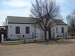 |
| 9/2/332/0004 | Old Reformed Church, Boshoff Street, Reddersburg | THE CHURCH IS BUILT IN A OBLONG SHAPE. IT HAS A BIG CONSISTORY IN THE NORTH. IT HAS GABLES ON BOTH S The Reformed Church at Reddersburg was erected in 1862 and is the mother church of the Reformed Church in the Orange Free State. Type of site: Church Previous use: Church. Current use: Church. | Reddersburg | Reddersburg | Provincial Heritage Site | 29°39′11″S 26°10′19″E / 29.653034°S 26.171879°E |
|
| 9/2/333/0002 | Nederduitse Gereformeerde Church, Church Street, Reitz | On 1912-08-10 Pres. M.T. Steyn laid the corner-stone of the Dutch Reformed church in Reitz. The bui Type of site: Church Current use: Church. One of the few conservation-worthy buildings in Reitz | Reitz | Reitz | Provincial Heritage Site | 27°48′17″S 28°25′48″E / 27.804634°S 28.429994°E |
|
| 9/2/333/0004 | Town Hall, Voortrekker Street, Reitz | Single storey brick building under hipped corrugated iron roof. Symmetrical front façade with pilasters, large triangular pediment and gable. Brick extensions on side levations with corrugated iron roofs. Timber doors and steel windows. The cornerstone of the building was laid on 12 February 1937 by the Mayor of Reitz, Councillor C H Walker. The building was officially opened on 14 December 1937 by the Administrator of the Orange Free State, Dr J F van Rensburg. Type of site: Town Hall Current use: Town Hall. The building, which was erected in 1937 was designed by the architect, H G E de la Cornillere. It is a typical example of a town hall built in the Free State and forms part of the history of eitz. | Reitz | Reitz | Register (Withdrawn) | 27°47′57″S 28°25′49″E / 27.799267°S 28.430206°E |
|
| 9/2/334/0001 | Dutch Reformed Church, Church Street, Rouxville | This an impressive building with its neo-gothic features, was built of sandstone. It has a tower, co This impressive sandstone building with its neo-Gothic features was designed by the architect Richard Wocke. The corner-stone was laid on 11 July 1879 and the building was officially inaugurated on 11 March 1881. The restored tower, which was designed by Architectural style: Neo-Gothic. Type of site: Church Previous use: Church. Current use: Church. This impressive sandstone building with its neo-Gothic features was designed by the architect Richard Wocke. The corner-stone was laid on 11 July 1879 and the building was officially inaugurated on 11 March 1881. The restored tower, which was designed by | Rouxville | Rouxville | Provincial Heritage Site | 30°25′01″S 26°50′06″E / 30.416984°S 26.834896°E |
|
| 9/2/334/0002-001 | Old turbine building, Goedemoed, Rouxville District | 0 | Rouxville | Register | 28°27′15″S 26°47′48″E / 28.454111°S 26.796785°E |
| |
| 9/2/334/0002-002 | Old school building, Goedemoed, Rouxville District | Type of site: School. | Rouxville | Register | 28°27′15″S 26°47′48″E / 28.454111°S 26.796785°E |
| |
| 9/2/334/0002-003 | Old church building, Goedemoed, Rouxville District | 0 | Rouxville | Register | 28°27′15″S 26°47′48″E / 28.454111°S 26.796785°E |
| |
| 9/2/334/0004 | Town Hall, Piet Retief Street, Rouxville | Single storeyed painted brick building under hipped corrugated iron roof with tower on roof ridge. Corrugated iron verandahs with iron columns. Three arched entrances in front façade. Timber doors and casement windows. Painted sandstone foundation. The building was erected in 1911 by the brothers Morton of Aliwal North. It was used as a cinema and for religious and political meetings. In 1961 the building was extensively modernised for the centenary celebrations of the town. Type of site: Town Hall Current use: Town Hall. The building was designed by the architect, H G E de la Cornillere and officially opened on 11 July 1911 by the Administrator of the Orange Free State, A E W Ramsbottom. It occupies an important place in the history of Rouxville. | Rouxville | Rouxville | Provisional Protection | 30°25′04″S 26°50′04″E / 30.417889°S 26.834549°E |
|
| 9/2/334/0005-001 | Tuishuisie, Roux Street, Rouxville | It is a single storey building with white painted walls and a pitched iron roof. The four panel timb It is suspected that the building were built for P.J.C. Swanepoel as 'tuishuisie' for his family. Th Architectural style: Republican. Type of site: House Current use: House. | Rouxville | Rouxville | Provincial Heritage Site | 30°24′56″S 26°50′04″E / 30.415508°S 26.834510°E |
|
| 9/2/335/0002 | Farm school, Taaiboschspruit, Sasolburg District | Type of site: School. This sandstone school building which was erected in 1916, remained fairly unaltered over the years. It is a fine example of the farm schools which played a significant educational role in the Free State during the first half of this century. | Sasolburg | Register | 26°53′30″S 27°53′40″E / 26.8916666666°S 27.8944444444°E |
| |
| 9/2/335/0003 | Muller House, Wonderfontein, Sasolburg District | Type of site: House. | Sasolburg | Provisional Protection | 26°48′59″S 27°54′58″E / 26.816478°S 27.916088°E |
| |
| 9/2/336/0001 | Dutch Reformed Mother Church, Church Square, Senekal | The church square is enclosed by a wall on which fossil tree trunks were placed in the forties. The corner-stone of the church was laid in 1895-06-06. This historic church building was designed by the architects J. H. and A. E. Till and built in sandstone by the contractors Rowe, Marshall and Hill. The building was consecrated in 1896.
The Church Type of site: Church Current use: Church. This historic church building was designed by the architects J. H. and A. E. Till and built in sandstone by the contractors Rowe, Marshall and Hill. The building was consecrated in 1896. The Church Square is enclosed by a wall on which fossil tree trunks |
Senekal | Senekal | Provincial Heritage Site | 28°19′22″S 27°37′20″E / 28.322660°S 27.622257°E |  |
| 9/2/336/0002 | Anglican Church, Berg Street, Senekal | Small sandstone building with corrugated iron roof. West façade ends in triangular gable. East façade The erf of the building was donated to the Anglican Church by Frederik M. Malan in 1880. A local lad Type of site: Church Current use: Church. The sandstone building, erected in the early 1880s, is one of the oldest remaining Anglican Church | Senekal | Senekal | Provisional Protection | 28°19′15″S 27°37′26″E / 28.320852°S 27.624013°E |
|
| 9/2/337/0001 | Mill building, Carmel, Smithfield District | Type of site: Commercial. The mill-building, together with the nearby tomb where Lemue and his wife are buried are the only tangible remainder of the former mission station at Carmel. It serves at a reminder of the valuable contribution made by earlier missionaries to the social, | Smithfield | Smithfield | Register | 30°12′45″S 26°31′53″E / 30.212500°S 26.531389°E |
|
| 9/2/337/0002 | Farmhouse, Beersheba, Smithfield District | Type of site: Farm Complex. | Smithfield | Provincial Heritage Site | 30°07′10″S 26°44′20″E / 30.119425°S 26.738901°E |
| |
| 9/2/337/0003 | Cemetery, Carmel, Smithfield District | Type of site: Cemetery. | Smithfield | Provincial Heritage Site | 30°20′40″S 26°17′11″E / 30.344458°S 26.286496°E |
| |
| 9/2/337/0005 | Police Station, Juana Square, Smithfield | Type of site: Police Station. | Smithfield | Smithfield | Register | 30°12′45″S 26°31′53″E / 30.212500°S 26.531389°E |  |
| 9/2/337/0007 | Erf 50, Church Street, Smithfield | It is a rectangular single storey building with plaster on the walls and painted white. It has a cor The building was erected in the late fifties of the nineteenth century. It was probably erected to s Architectural style: Republican. Type of site: House Current use: House. | Smithfield | Smithfield | Provincial Heritage Site | 30°12′54″S 26°32′10″E / 30.214880°S 26.536150°E |
|
| 9/2/337/0012 | Town Hall, Brand Street, Smithfield | Single storey plastered brick building under hipped corrugated iron roof. Symmetrical front façade with stepped gables and portico, built partially of sandstone. Verandahs on front and side elevations. Timber doors and steel and casement windows. The building was officially opened on 19 August 1925 by the Administrator of the Orange Free State, E R Grobler. Type of site: Town Hall Current use: Town Hall. The building, which was designed by the architect, H G E de la Cornillere, was erected in 1925. It is a fine example of a town hall built in the Free State and a landmark in the town. | Smithfield | Smithfield | Register | 30°13′03″S 26°31′45″E / 30.217417°S 26.529052°E |  |
| 9/2/337/0013 | Birthplace of C R de Wet, Kleinfontein 762, Smithfield District | About 24 kilometres north-west of Smithfield along the 214 main road to Edenburg, a road turns off to the right.
Some kilometres along this road one sees a large round hill known as Leeuwkop, standing up prominently above the horizon. This hill has given. These ruins are all that remain of the two-roomed clay cottage where Gen. C. R. de Wet was born on 7 October 1854. He lived here with his parents until the age of five. |
Smithfield | Provincial Heritage Site | 29°58′25″S 26°29′40″E / 29.973544°S 26.494418°E |
| |
| 9/2/338/0002 | Old Nederduitse Gereformeerde Church parsonage, 43 Sarel Cilliers Street, Theunissen | Type of site: Parsonage. | Theunissen | Theunissen | Register | 28°24′10″S 26°42′29″E / 28.402669°S 26.708064°E |
|
| 9/2/338/0004 | Town Hall, Le Roux Street, Theunissen | Single storey plastered brick building under hipped corrugated iron roof with ventilators on roof ridge. Front elevation provided with stepped gables and a tower on each corner. Steel windows. Brick plinth. The cornerstone of the building was laid on 10 March 1936 by the Mayor of Theunissen, J H van Heeren. The building contractor was D Watson and Son. The building was inaugurated on 21 October 1936. Type of site: Town Hall Current use: Town Hall. The building, which was erected in 1936, was designed by H A C Wallace. It forms part of the history of Theunissen and is a landmark in the town. | Theunissen | Theunissen | Register | 28°24′01″S 26°42′45″E / 28.400312°S 26.712439°E |
|
| 9/2/339/0003 | Town Hall, Voortrekker Street, Trompsburg | Single storey plastered brick building under hipped corrugated iron roof. Front elevation provided with sandstone gable and double timber door with arched fanlight. Steel windows. The cornerstone of the building was laid on 27 August 1926 by B Tromp (sen.) It was officially opened i (rest of text not in report. Does 'sen' mean Senator??) Type of site: Town Hall Current use: Town Hall. The building, which was erected in 1926/1927, forms part of the history of Trompsburg. | Trompsburg | Trompsburg | Register | 30°01′53″S 25°46′55″E / 30.031457°S 25.781981°E | 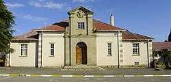 |
| 9/2/340/0001 | Nederduitse Gereformeerde Church, Steyn Street, Ventersburg | On 1912-10-13 the corner-stone was laid by Pres. M.T. Steyn. The building was inaugurated on 1913-07 Type of site: Church Current use: Church. | Ventersburg | Ventersburg | Provincial Heritage Site | 28°05′03″S 27°08′12″E / 28.084270°S 27.136626°E |  |
| 9/2/340/0002 | Early Sotho settlement, Waterval, Sandrivierhoogte, Ventersburg District | The corbelled huts was built of rocks. The rock walls that was built around the huts was two metres This village, which dates from the seventeenth century with its characteristic corbelled huts and stone kraals, is an excellent example of the architecture and way of life of the Leghoya in the Free State. Type of site: House Previous use: Argeological Site. This village, which dates from the seventeenth century with its characteristic corbelled huts and stone kraals, is an excellent example of the architecture and way of life of the Leghoya in the Free State. | Ventersburg | Provincial Heritage Site | 28°14′40″S 27°04′47″E / 28.244364°S 27.079706°E |
| |
| 9/2/340/0003 | Town Hall, Voortrekker Street, Ventersburg | Single storey plastered brick building under hipped corrugated iron roof with ventilators on roof ridge. Gables and lean-to verandah with pre-cast columns on front façade. Double timber main door with side lights and fan lights and steel windows. The cornerstone of the building was laid on 27 June 1928 by E R Grobler, Administrator of the Free State. The building contractor was H B Kruger. The building was officially inaugurated on 8 December 1928. Type of site: Town Hall Current use: Town Hall. The building, which was erected in 1928, forms part of the history of Ventersburg. | Ventersburg | Ventersburg | Register | 28°05′10″S 27°08′13″E / 28.086009°S 27.136942°E |  |
| 9/2/340/0004 | Skanskraal and Voortrekker Graves, Kromfontein, Ventersburg District | Type of site: Graves Voortrekker. | Ventersburg | Provincial Heritage Site | 28°05′06″S 27°07′45″E / 28.084969°S 27.129302°E |
| |
| 9/2/340/0005 | Old Police station complex, Ventersburg | Police Office Building: two room, iron building with timber sash windows, timber floors and timber c The building complex consist of a police station, prison, horse-stables, pound and rondavel. The Architectural style: Late Republican. Type of site: Police Station Previous use: Police Station. Current use: Police Museum. | Ventersburg | Ventersburg | Provincial Heritage Site | 28°05′16″S 27°08′10″E / 28.087862°S 27.136106°E |  |
| 9/2/341/0002 | Farmhouse and cooler, Thornvale, Viljoenskroon District | Type of site: Farm Complex. | Viljoenskroon | Provincial Heritage Site | 27°27′00″S 26°56′30″E / 27.45°S 26.9416666666°E |
| |
| 9/2/343/0001-001 | All Saints Anglican Church, 70 Church Street, Vrede | Small dolomite building with corrugated iron roof. Entrance porch provided with double timber door. The building was erected in 1890 by the building contractors Thomas Cowan and Aleck H. Doig of Harri Architectural style: Neo-gothic. Type of site: Church Current use: Church. The building with its Neo Gothic features which was erected in 1890, is a fine example of the Anglic | Vrede | Vrede | Provincial Heritage Site | 29°08′55″S 27°26′12″E / 29.1485111111°S 27.4366638888°E |
|
| 9/2/343/0003 | Nederduitse Gereformeerde Church, Church Square, Vrede | It is a single storey sandstone building with a corrugated iron roof. The building has two side wing The congregation of Vrede was established on 1882-03-04.The corner-stone was laid on 1887-10-31 by P Architectural style: Neo-gothic. Type of site: Church Current use: Church. | Vrede | Vrede | Provincial Heritage Site | 27°25′35″S 29°09′51″E / 27.426305°S 29.164053°E |
|
| 9/2/344/0002 | Post Office, 15 Oranje Street, Vredefort | Type of site: Post Office. | Vredefort | Vredefort | Provincial Heritage Site | 27°00′23″S 27°22′04″E / 27.006407°S 27.367734°E |  |
| 9/2/344/0003 | Nederduitse Gereformeerde Church, Church Street, Vredefort | Type of site: Church. | Vredefort | Vredefort | Register | 27°00′03″S 27°22′24″E / 27.000788°S 27.373399°E |  |
| 9/2/344/0004 | Nederduitse Gereformeerde Church Hall, Church Street, Vredefort | Type of site: Church Hall. | Vredefort | Vredefort | Register | 27°00′19″S 27°22′03″E / 27.005329°S 27.367530°E |  |
| 9/2/344/0005 | 30 Charl Cilliers Street, Vredefort | Type of site: House. | Vredefort | Vredefort | Register | 27°00′16″S 27°22′07″E / 27.004344°S 27.368667°E |  |
| 9/2/345/0001 | MOTH Club House, 24 12th Street, Voorspoed East, Welkom | Type of site: Moth Club. | Welkom, Voorspoed | Welkom | Register | 27°59′03″S 26°46′36″E / 27.984075°S 26.7767416666°E |
|
| 9/2/346/0001 | First dwelling-house of President J P Hoffman and the family cemetery, Hoffmansrust, Wepener District | Type of site: Cemetery. | Wepener | Register | 28°27′15″S 26°47′48″E / 28.454111°S 26.796785°E |
| |
| 9/2/346/0007 | Robertson Church and Cemetery, Jammersberg Drift, Wepener District | Each grave is clearly marked with the name and regiment of the fallen soldier and the cemetery is su The Jammersdrif battle took here place. The cemetery is the last resting place of the Robertson family. Architectural style: Neo Gothic. Type of site: Church, Cemetery Current use: Church and Cemetery. | Wepener | Provincial Heritage Site | 29°42′46″S 26°58′49″E / 29.712722°S 26.980166°E |
| |
| 9/2/346/0007-001 | Jammerberg Drift Battlefield, Anniesdale, Wepener District | Type of site: Battlefield. At this battlefield in April 1900 Col. E. H. Dalgety and his Colonial Division of about 2000 men were besieged for 16 days by Gen. Christiaan de Wet and his superior force of almost 6 000 men. Owing to the arrival of British reinforcements, Gen. De Wet ha | Wepener | Provincial Heritage Site | 29°43′00″S 26°59′00″E / 29.7166666666°S 26.9833333333°E |
| |
| 9/2/346/0008 | Old wagon-bridge, Caledon River, Jammerbergs Brug, Wepener District | It is a steel arch bridge with sandstone foot pieces. In the rainy season Caledon was cut off from the rest of the Free State and therefore a bridge was built. Type of site: Bridge Current use: Bridge. | Wepener | Provincial Heritage Site | 29°42′46″S 26°59′10″E / 29.712657°S 26.986046°E |
| |
| 9/2/346/0009 | Town Hall, De Beer Street, Wepener | Single storey plastered brick building under hipped corrugated iron roof with ventilator on roof ridge. Front façade provided with tower and projecting bay with pediment and pilasters. Double timber doors and casement windows. Red painted brick plinth. The building was officially opened on 31 May 1928 by the Mayor of Wepener, Councillor D du Plessis. Th building contractor was D J H Spies. In 1963 the building was repaired and modernised. Type of site: Town Hall Current use: Town Hall. The building, which was designed by the architect H G E de la Cornillere, was erected in 1927. It is a fine example of a town hall, built in the Free State. It forms part of the history of Wepener and is a landmark in the town. | Wepener | Wepener | Register | 29°43′43″S 27°02′20″E / 29.728473°S 27.038832°E |
|
| 9/2/348/0001 | Dutch Reformed Church, Church Square, Winburg | The church is built of sandstone in a neo-gothic style. It has a big tower. This imposing neo-Gothic sandstone church was designed by the architects J. H. and A. E. Till and erected by the builders Rundle, Rowe and Marshall. The comer-stone was laid on 20 January 1899 by M. T. Steyn, President of the Orange Free State. During the Architectural style: Neo-Gothic. Type of site: Church Previous use: Hospital. Current use: Church. This imposing neo-Gothic sandstone church was designed by the architects J. H. and A. E. Till and erected by the builders Rundle, Rowe and Marshall. The comer-stone was laid on 20 January 1899 by M. T. Steyn, President of the Orange Free State. During the | Winburg | Winburg | Provincial Heritage Site | 28°31′07″S 27°00′42″E / 28.518659°S 27.011744°E | 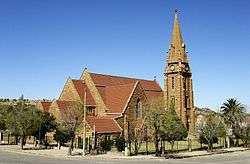 |
| 9/2/348/0004 | Military Cemetery, Winburg | The terrain has a fence. The graves have silver painted iron crosses on a cement pedestal. The cemetery contains the mortal remains of women and children who died during the Anglo-Boer War (1 Type of site: Cemetery Military Current use: Graveyard. | Winburg | Winburg | Provincial Heritage Site | 28°31′10″S 27°00′25″E / 28.519413°S 27.006873°E |  |
| 9/2/348/0011 | Town Hall, Andries Pretorius Square, Winburg | Single storey red brick building under hipped corrugated iron roof. Stoep with pre-cast columns in front of main entrance. Brick extensions with corrugated iron roofs on side elevations. Timber doors and steel windows. The cornerstone of the building was laid on 23 March 1938 by Dr J F J van Rensburg, Administrator of the Orange Free State. Type of site: Town Hall Current use: Town Hall. The building, which was erected in 1938, forms part of the history of Winburg and is a landmark in the town. | Winburg | Winburg | Register | 28°32′00″S 27°01′00″E / 28.533333°S 27.016667°E |  |
| 9/2/350/0001-001 | House of Jan de Winnaar, Higgs Street, Zastron | Type of site: House. This Voortrekker cottage dates from the early nineteenth century. It was erected by one of the first European settlers in the South-eastern Free State, Jan Hendrik de Winnaar. | Zastron | Zastron | Deproclaimed | 30°18′00″S 27°05′00″E / 30.300000°S 27.083333°E |
|
| 9/2/501/0002 | Archbell House, St Paul's Mission, Thaba 'Nchu | The house is built of coursed cut stone and has a metal tile roof. After the Barolong tribe had moved from Platberg to Thaba Nchu in 1833, the church and the Rev. Archbell's mission house were re-erected here. Between 1836 and 1839 this house of the Rev. Archbell was probably enlarged. Type of site: House Previous use: House. After the Barolong tribe had moved from Platberg to Thaba Nchu in 1833, the church and the Rev. Archbell's mission house were reerected here. Between 1836 and 1839 this house of the Rev. Archbell was probably enlarged. | Thaba Nchu | Provincial Heritage Site | 29°13′03″S 26°50′57″E / 29.217419°S 26.849213°E |
| |
| The Burgher monument, Boomplaats, Edenburg District | Structures on Property: A monument of blue dolerite (iron stone), erected in 1938, toilets of brick, a few reed-and-grass structures a corrugated iron shed and a donkey-boiler of stone. Boomplaats is the site of the historical battle on 29 August 1848 between the British forces under the command of the Governor of the Cape, Sir Harry Smith, and a Boer Commando led by Gen. Andries Pretorius. The Monument was erected on 16 December 1938 a Approximately 100km South West of Bloemfontein. | Edenburg | Edenburg | Provincial Heritage Site |
|
Lists of South African Heritage Resources | ||||||||||||||||||||||||||||||||||||
|---|---|---|---|---|---|---|---|---|---|---|---|---|---|---|---|---|---|---|---|---|---|---|---|---|---|---|---|---|---|---|---|---|---|---|---|---|
| SAHRA Heritage sites |
| |||||||||||||||||||||||||||||||||||
| World heritage sites | ||||||||||||||||||||||||||||||||||||
References
| Wikimedia Commons has media related to Cultural heritage monuments in Free State. |
Lists of South African Heritage Resources | ||||||||||||||||||||||||||||||||||||
|---|---|---|---|---|---|---|---|---|---|---|---|---|---|---|---|---|---|---|---|---|---|---|---|---|---|---|---|---|---|---|---|---|---|---|---|---|
| SAHRA Heritage sites |
| |||||||||||||||||||||||||||||||||||
| World heritage sites | ||||||||||||||||||||||||||||||||||||