List of historic places in Regional Municipality of Peel
Brampton
| Name | Address | Municipality | PC | Coordinates | IDF | IDP | IDM | |
Image |
|---|---|---|---|---|---|---|---|---|---|
| Armoury | 2 Chapel Street | Brampton | 43°41′12″N 79°45′28″E / 43.6867°N 79.7579°E | 9726 |  | ||||
| Brampton GO Station and VIA Station, formerly a Canadian National Railways station | 27 Church Street West | Brampton | L6X | 43°41′13″N 79°45′54″E / 43.687°N 79.765°E | 4567 |  More images | |||
| Dominion Building | 8 Queen Street East | Brampton | L6V | 43°41′10″N 79°45′35″E / 43.686237°N 79.759672°E | 9743 | 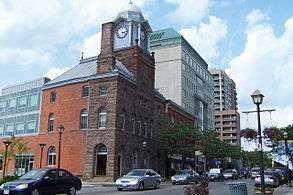 More images |
Caledon
Mississauga


Unsorted
| Name | Address | Municipality | PC | Coordinates | IDF | IDP | IDM | |
Image |
|---|---|---|---|---|---|---|---|---|---|
| Lislehurst | 3369 Mississauga Road | Mississauga | 43°33′17″N 79°40′05″E / 43.5546°N 79.668°E | 14962 |  | ||||
| McClure House | 2075, Derry Road West | Mississauga | 43°36′22″N 79°45′07″E / 43.6061°N 79.752°E | 15653 |  | ||||
| Meadowvale Village Hall | 6970, Second Line West | Mississauga | 43°37′35″N 79°43′37″E / 43.6264°N 79.727°E | 15496 |  | ||||
| Meadowvale Village Heritage Conservation District | Along Old Derry Road, from a visual narrowing of the road from the east and the Credit River from the west. The northern limit to the village occurs at the intersection of Pond Street and the southern limit is considered the Community Hall property. | Mississauga | 43°37′38″N 79°43′39″E / 43.6271°N 79.7276°E | 15170 |  | ||||
| Middle Road Bridge | 1700 Sherway Drive | Mississauga | L4X | 43°36′25″N 79°34′08″E / 43.607°N 79.569°E | 3026 |  More images | |||
| Montreal House | 210 Queen Street South | Mississauga | L5M | 43°34′51″N 79°42′47″E / 43.5809°N 79.713°E | 14584 | 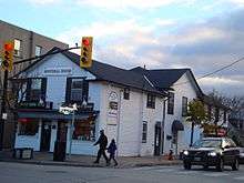 | |||
| Moore-Stanfield House | 1295, Burnhamthorpe | Mississauga | 43°37′08″N 79°36′23″E / 43.6188°N 79.6065°E | 15158 |  | ||||
| Moore's Cemetery | 2030, Derry | Mississauga | 43°41′07″N 79°39′46″E / 43.6854°N 79.6628°E | 15132 |  | ||||
| Old Erindale Public School | 3057 Mississauga Road | Mississauga | 43°32′39″N 79°39′42″E / 43.5443°N 79.6616°E | 15110 |  | ||||
| Old Grammar School | 327, Queen Street South | Mississauga | L5N | 43°35′31″N 79°43′30″E / 43.592°N 79.725°E | 14583 |  | |||
| Old Port Credit Heritage Conservation District | Bounded by Lakeshore Road West, Lake Ontario, Mississauga Road South, and the Credit River | Mississauga | 43°32′52″N 79°35′10″E / 43.5477°N 79.5862°E | 15169 | | ||||
| Paterson Manning House | 13 Thomas Street | Mississauga | L5M | 43°34′47″N 79°42′45″E / 43.5798°N 79.7124°E | 14591 | | |||
| Riverwood | 1447, Burnhamthorpe Road | Mississauga | L5C | 43°33′47″N 79°40′15″E / 43.563°N 79.6709°E | 14143 |  More images | |||
| Robert Sloan House | 831, Sunningdale Bend | Mississauga | 43°30′51″N 79°37′12″E / 43.5142°N 79.6201°E | 15655 | | ||||
| Robinson-Adamson House | 1921, Dundas Street West | Mississauga | 43°32′22″N 79°39′49″E / 43.5395°N 79.6635°E | 15498 |  | ||||
| Sayers/Larson Residence | 1723, Birchwood Drive | Mississauga | 43°31′24″N 79°37′49″E / 43.5233°N 79.6304°E | 16326 |  | ||||
| St. Andrew's Presbyterian Church | 295 Queen Street South | Mississauga | L5M | 43°34′44″N 79°42′35″E / 43.5788°N 79.7098°E | 14593 |  | |||
| St. Lawrence Starch Limited Administration Building | 141, Lakeshore Road East | Mississauga | L5G | 43°33′19″N 79°34′53″E / 43.5553°N 79.5815°E | 13846 |  | |||
| St. Peter's Rectory | 1556, Dundas | Mississauga | 43°32′46″N 79°39′10″E / 43.5462°N 79.6527°E | 15189 | | ||||
| Streetsville Village Hall | 280 Queen Street South | Mississauga | 43°34′44″N 79°42′38″E / 43.579°N 79.7105°E | 15522 |  | ||||
| Sylvan Oaks | 7564, Tenth | Mississauga | 43°35′51″N 79°47′42″E / 43.5974°N 79.7949°E | 14983 | | ||||
| The Kindree Family Cemetery | 3790, Derry Road West | Mississauga | L5N | 43°34′44″N 79°46′53″E / 43.579°N 79.7814°E | 3027 | | |||
| Timothy Street House | 41, Mill Street | Mississauga | 43°34′57″N 79°42′36″E / 43.5826°N 79.71°E | 15499 |  | ||||
| Tomlinson-Johnston House | 16 Scarboro Street | Mississauga | L4T | 43°42′21″N 79°38′52″E / 43.7057°N 79.6478°E | 13822 |  | |||
| W. T. Gray House | 90 High Street East | Mississauga | 43°33′22″N 79°34′59″E / 43.556°N 79.583°E | 15673 | | ||||
| William Barber House | 5155 Mississauga Road | Mississauga | L5M | 43°34′17″N 79°41′58″E / 43.5714°N 79.6995°E | 13821 |  | |||
| William Cunningham House | 19 Barry Avenue | Mississauga | L5M | 43°34′44″N 79°42′42″E / 43.5788°N 79.7116°E | 13817 |  | |||
| 16775 Centreville Creek Road | 16775 Centreville Creek Road | Caledon | 43°53′19″N 79°50′43″W / 43.8886°N 79.8452°W | 15445 | | ||||
| Alexander Smith Farm Complex | 14650 Heart Lake Road | Caledon | 43°47′45″N 79°51′41″W / 43.7958°N 79.8614°W | 15523 | | ||||
| Alton Mechanics' Institute and Library | 1456 Queen Street West | Caledon | 43°51′33″N 80°04′12″W / 43.8593°N 80.0699°W | 15525 | | ||||
| Alton Mill | 1402 Queen Street | Caledon | L7K | 43°51′N 80°04′W / 43.85°N 80.07°W | 2088 | | |||
| Balsam Villa | 19179 Centreville Creek | Caledon | 43°57′02″N 79°55′48″W / 43.9506°N 79.93°W | 15446 | | ||||
| Caledon Agricultural Society Building | 18297 Hurontario Street | Caledon | 43°51′29″N 79°59′34″W / 43.858°N 79.9929°W | 15468 | | ||||
| Cheltenham Store | 14386 Creditview Road | Caledon | 43°45′07″N 79°55′16″W / 43.7519°N 79.9212°W | 15477 | | ||||
| Claude Presbyterian Church | 15175 Hurontario Street | Caledon | 43°47′47″N 79°54′35″W / 43.7965°N 79.9096°W | 15470 |  | ||||
| Cunnington-Osborne Complex | 5164 The Grange Sideroad | Caledon | 43°51′46″N 79°53′42″W / 43.8629°N 79.8951°W | 15157 | | ||||
| Graham Mill | 104 Maple Avenue | Caledon | 43°47′38″N 79°55′33″W / 43.7939°N 79.9257°W | 15479 | | ||||
| Greystone Farm | 396 King Street | Caledon | 43°43′17″N 79°55′57″W / 43.7214°N 79.9326°W | 15481 | | ||||
| Haines-Lyons House | 14318 Creditview Road | Caledon | 43°45′01″N 79°55′09″W / 43.7504°N 79.9193°W | 15246 | | ||||
| Laurel Hill Cemetery | 389 Centennial | Caledon | 43°53′08″N 79°44′48″W / 43.8856°N 79.7466°W | 15482 | |
| Wikimedia Commons has media related to Cultural heritage monuments in Peel Regional Municipality. |
This article is issued from Wikipedia - version of the 5/9/2016. The text is available under the Creative Commons Attribution/Share Alike but additional terms may apply for the media files.