List of mountains in Deer Lodge County, Montana
This list is incomplete; you can help by expanding it.
There are at least 34 named mountains in Deer Lodge County, Montana.
- Bear Mountain, 45°54′38″N 113°00′30″W / 45.91056°N 113.00833°W, el. 8,648 feet (2,636 m)[1]
- Beaverhead Mountain, 46°00′02″N 113°23′56″W / 46.00056°N 113.39889°W, el. 9,613 feet (2,930 m)[2]
- Blizzard Hill, 46°15′07″N 112°34′17″W / 46.25194°N 112.57139°W, el. 7,638 feet (2,328 m)[3]
- Cottonwood Mountain, 46°13′19″N 112°38′28″W / 46.22194°N 112.64111°W, el. 6,942 feet (2,116 m)[4]
- East Goat Peak, 45°57′22″N 113°22′47″W / 45.95611°N 113.37972°W, el. 10,390 feet (3,170 m)[5]
- East Pintler Peak, 45°56′54″N 113°30′01″W / 45.94833°N 113.50028°W, el. 9,442 feet (2,878 m)[6]
- Fish Peak, 46°00′19″N 113°20′07″W / 46.00528°N 113.33528°W, el. 10,197 feet (3,108 m)[7]
- Garrity Mountain, 46°08′46″N 113°05′24″W / 46.14611°N 113.09000°W, el. 8,045 feet (2,452 m)[8]
- Gospel Hill, 46°14′27″N 112°36′15″W / 46.24083°N 112.60417°W, el. 7,270 feet (2,220 m)[9]
- Grassy Mountain, 46°01′48″N 113°00′51″W / 46.03000°N 113.01417°W, el. 7,985 feet (2,434 m)[10]
- Grouse Hill, 46°10′55″N 113°10′23″W / 46.18194°N 113.17306°W, el. 7,116 feet (2,169 m)[11]
- Hidden Lake Hill, 46°12′58″N 113°11′43″W / 46.21611°N 113.19528°W, el. 7,716 feet (2,352 m)[12]
- Johnson Hill, 46°12′37″N 113°08′19″W / 46.21028°N 113.13861°W, el. 8,041 feet (2,451 m)[13]
- Long Peak, 45°58′08″N 113°21′18″W / 45.96889°N 113.35500°W, el. 9,521 feet (2,902 m)[14]
- McGlaughlin Peak, 45°58′06″N 113°28′06″W / 45.96833°N 113.46833°W, el. 9,478 feet (2,889 m)[15]
- Mount Evans, 46°03′00″N 113°11′26″W / 46.05000°N 113.19056°W, el. 10,594 feet (3,229 m)[16]
- Mount Haggin, 46°05′14″N 113°05′47″W / 46.08722°N 113.09639°W, el. 10,607 feet (3,233 m)[17]
- Mount Howe, 46°02′53″N 113°12′59″W / 46.04806°N 113.21639°W, el. 10,472 feet (3,192 m)[18]
- Needle Peak, 45°57′56″N 113°20′43″W / 45.96556°N 113.34528°W, el. 9,226 feet (2,812 m)[19]
- Nipple Peak, 45°56′33″N 113°23′02″W / 45.94250°N 113.38389°W, el. 9,662 feet (2,945 m)[20]
- Olson Mountain, 46°12′27″N 113°04′42″W / 46.20750°N 113.07833°W, el. 8,865 feet (2,702 m)[21]
- Orofino Mountain, 46°14′29″N 112°38′35″W / 46.24139°N 112.64306°W, el. 6,883 feet (2,098 m)[22]
- Pine Hill, 45°50′21″N 113°20′45″W / 45.83917°N 113.34583°W, el. 6,558 feet (1,999 m)[23]
- Pintler Peak, 45°56′55″N 113°30′00″W / 45.94861°N 113.50000°W, el. 9,478 feet (2,889 m)[24]
- Queener Mountain, 46°01′24″N 113°18′03″W / 46.02333°N 113.30083°W, el. 10,148 feet (3,093 m)[25]
- Saddle Mountain, 45°57′33″N 113°23′15″W / 45.95917°N 113.38750°W, el. 10,197 feet (3,108 m)[26]
- Saratoga Mountain, 46°15′39″N 112°35′53″W / 46.26083°N 112.59806°W, el. 6,952 feet (2,119 m)[27]
- Short Peak, 46°03′34″N 113°06′25″W / 46.05944°N 113.10694°W, el. 10,282 feet (3,134 m)[28]
- Silver Hill, 46°08′24″N 113°13′57″W / 46.14000°N 113.23250°W, el. 7,831 feet (2,387 m)[29]
- Spring Hill, 46°10′37″N 113°10′17″W / 46.17694°N 113.17139°W, el. 6,890 feet (2,100 m)[30]
- Sugarloaf Mountain, 46°00′47″N 112°57′23″W / 46.01306°N 112.95639°W, el. 7,677 feet (2,340 m)[31]
- Tower Peak, 45°57′51″N 113°20′06″W / 45.96417°N 113.33500°W, el. 8,809 feet (2,685 m)[32]
- West Goat Peak, 45°57′46″N 113°23′42″W / 45.96278°N 113.39500°W, el. 10,784 feet (3,287 m)[33]
- Wraith Hill, 46°10′26″N 113°13′15″W / 46.17389°N 113.22083°W, el. 7,201 feet (2,195 m)[34]
See also
Notes
- ↑ "Bear Mountain". Geographic Names Information System. United States Geological Survey.
- ↑ "Beaverhead Mountain". Geographic Names Information System. United States Geological Survey.
- ↑ "Blizzard Hill". Geographic Names Information System. United States Geological Survey.
- ↑ "Cottonwood Mountain". Geographic Names Information System. United States Geological Survey.
- ↑ "East Goat Peak". Geographic Names Information System. United States Geological Survey.
- ↑ "East Pintler Peak". Geographic Names Information System. United States Geological Survey.
- ↑ "Fish Peak". Geographic Names Information System. United States Geological Survey.
- ↑ "Garrity Mountain". Geographic Names Information System. United States Geological Survey.
- ↑ "Gospel Hill". Geographic Names Information System. United States Geological Survey.
- ↑ "Grassy Mountain". Geographic Names Information System. United States Geological Survey.
- ↑ "Grouse Hill". Geographic Names Information System. United States Geological Survey.
- ↑ "Hidden Lake Hill". Geographic Names Information System. United States Geological Survey.
- ↑ "Johnson Hill". Geographic Names Information System. United States Geological Survey.
- ↑ "Long Peak". Geographic Names Information System. United States Geological Survey.
- ↑ "McGlaughlin Peak". Geographic Names Information System. United States Geological Survey.
- ↑ "Mount Evans". Geographic Names Information System. United States Geological Survey.
- ↑ "Mount Haggin". Geographic Names Information System. United States Geological Survey.
- ↑ "Mount Howe". Geographic Names Information System. United States Geological Survey.
- ↑ "Needle Peak". Geographic Names Information System. United States Geological Survey.
- ↑ "Nipple Peak". Geographic Names Information System. United States Geological Survey.
- ↑ "Olson Mountain". Geographic Names Information System. United States Geological Survey.
- ↑ "Orofino Mountain". Geographic Names Information System. United States Geological Survey.
- ↑ "Pine Hill". Geographic Names Information System. United States Geological Survey.
- ↑ "Pintler Peak". Geographic Names Information System. United States Geological Survey.
- ↑ "Queener Mountain". Geographic Names Information System. United States Geological Survey.
- ↑ "Saddle Mountain". Geographic Names Information System. United States Geological Survey.
- ↑ "Saratoga Mountain". Geographic Names Information System. United States Geological Survey.
- ↑ "Short Peak". Geographic Names Information System. United States Geological Survey.
- ↑ "Silver Hill". Geographic Names Information System. United States Geological Survey.
- ↑ "Spring Hill". Geographic Names Information System. United States Geological Survey.
- ↑ "Sugarloaf Mountain". Geographic Names Information System. United States Geological Survey.
- ↑ "Tower Peak". Geographic Names Information System. United States Geological Survey.
- ↑ "West Goat Peak". Geographic Names Information System. United States Geological Survey.
- ↑ "Wraith Hill". Geographic Names Information System. United States Geological Survey.
Municipalities and communities of Deer Lodge County, Montana, United States | ||
|---|---|---|
| City | 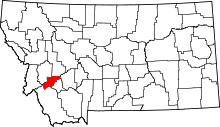 | |
| Unincorporated communities | ||
| Ghost town | ||
This article is issued from Wikipedia - version of the 6/20/2011. The text is available under the Creative Commons Attribution/Share Alike but additional terms may apply for the media files.