List of neighbourhoods in Mumbai
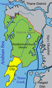
The city of Mumbai consists of two distinct regions: Mumbai City district and Mumbai Suburban district, which form two separate revenue districts of Maharashtra.[1] The city district region is also commonly referred to as the Island City or South Mumbai.[2] Mumbai Suburban district lies to the north of Mumbai City district and comprises all of Mumbai's suburbs. The western part of the Mumbai Suburban district forms the Western Suburbs and the eastern portion forms the Eastern Suburbs. The suburbs of Chembur, Govandi, Mankhurd and Trombay lie to the south-east of the Eastern Suburbs. These suburbs are generally not considered as part of the Eastern Suburbs and are sometimes referred to as the "Harbour Suburbs".
The total area of Mumbai is 603.4 km2 (233 sq mi).[3] Of this, the island city spans 67.79 km2 (26 sq mi), while the suburban district spans 370 km2 (143 sq mi), together accounting for 437.71 km2 (169 sq mi) under the administration of Brihanmumbai Municipal Corporation (BMC). The remaining area belongs to Defence, Mumbai Port Trust, Atomic Energy Commission and Borivali National Park, which are out of the jurisdiction of the BMC.[4] Mumbai lies at the mouth of the Ulhas River on the western coast of India, in the coastal region known as the Konkan. It sits on Salsette Island, partially shared with the Thane district.[5] Mumbai is bounded by the Arabian Sea to the west.[6] Borivali National Park is located partly in the Mumbai suburban district, and partly in the Thane district, and it extends over an area of 103.09 km2 (39.80 sq mi).[7]
Western Suburbs
Andheri
- Amboli
- Chakala
- D.N. Nagar
- Four Bungalows
- JB Nagar
- Lokhandwala
- Marol
- Model Town
- Oshiwara
- Poonam Nagar
- Sahar
- Saki Naka
- Seven Bungalows
- Versova
Bandra
- Bandra Kurla Complex
- Bandstand Promenade
- Gandhi Nagar
- Kherwadi
- Land's End
- Pali Hill
Borivali
- I.C. Colony
- Eksar Colony
- Shimpoli
- Magathane
- Nancy Colony
- Sukurwadi
- Gorai
- Kora Kendra
- Vazira
- Babhai
- Chikuwadi
Dahisar
Mira Road
Goregaon
- Aarey Milk Colony
- Bangur Nagar
- Gokuldham
- Pandurangwadi
- NESCO colony
Jogeshwari
- Jogeshwari West
- Jogeshwari East
Kandivali
Malad
Santacruz
Vile Parle
Juhu
Eastern Suburbs
Ghatkopar
- Amrut Nagar
- Asalfa
- Garodia Nagar
- Jagdusha Nagar
- Pant Nagar
Kurla
Powai
Vikhroli
- Gandhi Nagar
- Kannamwar Nagar
- Vikhroli Park Site
Harbour Suburbs
Chembur
Govandi
South Mumbai
- Agripada
- Altamount Road
- Bhuleshwar
- Breach Candy
- Carmichael Road
- Cavel
- Churchgate
- Cotton Green
- Cuffe Parade
- Cumbala Hill
- Currey Road
- Dhobitalao
- Dongri
- Kala Ghoda
- Kemps Corner
- Lalbaug
- Lower Parel
- Mahalaxmi
- Mahim
- Malabar Hill
- Marine Drive, Mumbai
- Marine Lines
- Mumbai Central
- Nariman Point
- Prabhadevi
- Sion
- Walkeshwar
- Worli
Antop Hill
Byculla
Colaba
Dadar
Fort
Girgaon
Kalbadevi
Kamathipura
Matunga
Parel
Tardeo
Other
See also
References
- ↑ "Mumbai Suburban" (PDF). National Informatics Centre (Mahrashtra State Centre). Retrieved 2009-15-31. Check date values in:
|access-date=(help) - ↑ "Mumbai Urban Infrastructure Project". Mumbai Metropolitan Region Development Authority (MMRDA). Archived from the original on February 26, 2009. Retrieved 18 July 2008.
- ↑ "Area and Density – Metropolitan Cities". Ministry of Urban Development (Government of India). p. 33. Archived from the original (PDF) on 29 April 2009. Retrieved 28 April 2008.
- ↑ Mumbai Plan, 1.2 Area and Divisions
- ↑ Greater Bombay District Gazetteer 1960, p. 2
- ↑ Mumbai Plan, 1.1 Location
- ↑ Bapat 2005, pp. 111–112