List of protected heritage sites in Arlon
This table shows an overview of the protected heritage sites in the Walloon town Arlon. This list is part of Belgium's national heritage.
| Object |
Year/architect |
Town/section |
Address |
Coordinates |
Number? |
Image |
|---|---|---|---|---|---|---|
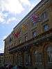
| Provincial palace and surroundings (nl) (fr) |
Arlon | place Léopold n°1 | 49°40′58″N 5°48′46″E / 49.682824°N 5.812677°E |
81001-CLT-0002-01 Info |
 | |
| Castle Sterpenich (nl) (fr) |
Arlon Sterpenich | rue de Berlaymont, Autelbas | 49°38′51″N 5°53′20″E / 49.647411°N 5.888999°E |
81001-CLT-0003-01 Info |
 | |
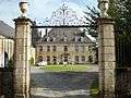
| Castle Autelbas (nl) (fr) |
Arlon Autelbas | Neiewee | 49°38′49″N 5°51′54″E / 49.64705°N 5.86505°E |
81001-CLT-0004-01 Info |
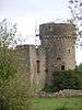 | |
| Castle Guirsch (nl) (fr) |
Arlon | 49°43′08″N 5°51′19″E / 49.719014°N 5.855268°E |
81001-CLT-0005-01 Info |
 | ||
| Castle Guirsch extension to chateau (nl) (fr) |
Arlon | rue du Château (S). | 49°43′10″N 5°51′18″E / 49.719335°N 5.854910°E |
81001-CLT-0006-01 Info |
.JPG) | |
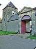
| Chapel of St. Aubin de Heckbous (nl) (fr) |
Arlon | Guirsch | 49°42′35″N 5°51′46″E / 49.709767°N 5.862761°E |
81001-CLT-0007-01 Info |
 | |
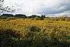
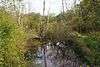
| Les Marais de Heinsch |
Arlon | 49°41′38″N 5°43′35″E / 49.693959°N 5.726252°E |
81001-CLT-0009-01 Info |
 | ||
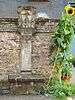
| Ossuary (nl) (fr) |
Arlon | rue Dominique (actuellement rue Saint-Servais, devant le n°55) | 49°38′11″N 5°46′20″E / 49.636266°N 5.772295°E |
81001-CLT-0010-01 Info |
 | |
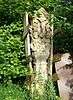
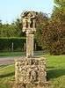
| Cross placed at roadside (nl) (fr) |
Arlon | rue de Habergy, à gauche du n°1 | 49°38′09″N 5°46′12″E / 49.635919°N 5.770082°E |
81001-CLT-0011-01 Info |
 | |
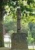
| Ossuary in the graveyard of Udange (nl) (fr) |
Arlon | 49°38′22″N 5°45′42″E / 49.639563°N 5.761574°E |
81001-CLT-0012-01 Info |
 | ||
| Ossuary (nl) (fr) |
Arlon | rue Haute, links van nummer 56 | 49°39′09″N 5°46′47″E / 49.652553°N 5.779790°E |
81001-CLT-0013-01 Info |
 | |
| Stations of the Cross (nl) (fr) |
Arlon | 49°38′25″N 5°46′29″E / 49.640374°N 5.774672°E |
81001-CLT-0015-01 Info |
 | ||
| Public toilet (nl) (fr) |
Arlon | 49°41′56″N 5°44′51″E / 49.698901°N 5.747556°E |
81001-CLT-0017-01 Info |
 | ||
| Stations of the Cross (nl) (fr) |
Arlon | rue de la Gendarmerie, face au n°8, à Sterpenich | 49°38′52″N 5°53′25″E / 49.647741°N 5.890263°E |
81001-CLT-0022-01 Info |
 | |
| Stations of the Cross (nl) (fr) |
Arlon | rue du Hämmelsmarsch, devant le n°32 | 49°39′04″N 5°51′57″E / 49.651034°N 5.865937°E |
81001-CLT-0023-01 Info |
.jpg) | |
| Stations of the Cross (nl) (fr) |
Arlon | Sterpenich cemetery | 49°38′59″N 5°53′20″E / 49.649629°N 5.888999°E |
81001-CLT-0024-01 Info |
.JPG) | |
| Stations of the Cross (nl) (fr) |
Arlon | rue du Centre across from number 6 | 49°40′58″N 5°50′12″E / 49.682754°N 5.836784°E |
81001-CLT-0025-01 Info |
.JPG) | |
| Stations of the Cross (nl) (fr) |
Arlon | 23 rue de Hondelange | 49°39′03″N 5°50′32″E / 49.650890°N 5.842245°E |
81001-CLT-0026-01 Info |
||
| Stations of the Cross (nl) (fr) |
Arlon | De Cle des Champs, in front of number 3 | 49°39′30″N 5°50′14″E / 49.658372°N 5.837184°E |
81001-CLT-0027-01 Info |
.JPG) | |
| Stations of the Cross <sup style="text-align:right; line-height:1em;
margin-left:0.3em; color:blue; cursor:help; font-family:Verdana,sans-serif;"
title="Kruisweg op een plaats genaamd "Grubermühle"">(nl) (fr) |
Arlon | Grubermühle | 49°43′23″N 5°50′13″E / 49.722928°N 5.837051°E |
81001-CLT-0028-01 Info |
 | |
| Stations of the Cross (nl) (fr) |
Arlon | Heckbous-Guirsch | 49°43′14″N 5°51′27″E / 49.720588°N 5.857557°E |
81001-CLT-0029-01 Info |
 | |
| Stations of the Cross (nl) (fr) |
Arlon | corner of rue de la Sablière and Fouche road | 49°41′06″N 5°42′42″E / 49.685016°N 5.711800°E |
81001-CLT-0030-01 Info |
 | |
| Stations of the Cross (nl) (fr) |
Arlon | vallée des Trois Moulins | 49°42′22″N 5°51′03″E / 49.706089°N 5.850906°E |
81001-CLT-0031-01 Info |
 | |
| Stations of the Cross (nl) (fr) |
Arlon | rue de Hachy, near number 95 | 49°41′35″N 5°41′42″E / 49.693086°N 5.695096°E |
81001-CLT-0032-01 Info |
 | |
| Trail to St. Donat (nl) (fr) |
Arlon | 49°41′03″N 5°48′57″E / 49.684129°N 5.815854°E |
81001-CLT-0033-01 Info |
 | ||
| Old house (nl) (fr) |
Arlon | avenue de la Gare, 29 | 49°40′50″N 5°48′37″E / 49.680610°N 5.810376°E |
81001-CLT-0034-01 Info |
 | |
| Parts of building called "Les Caves" <sup style="text-align:right; line-height:1em;
margin-left:0.3em; color:blue; cursor:help; font-family:Verdana,sans-serif;"
title="Delen van het gebouw genaamd "Les Caves"">(nl) (fr) |
Arlon | Grand-Rue, 57 | 49°40′59″N 5°48′58″E / 49.682961°N 5.816242°E |
81001-CLT-0035-01 Info |
||
| Du Landbrough House <sup style="text-align:right; line-height:1em;
margin-left:0.3em; color:blue; cursor:help; font-family:Verdana,sans-serif;"
title=""du Landbrough" en omgeving">(nl) (fr) |
Arlon | 49°39′17″N 5°41′01″E / 49.654740°N 5.683657°E |
81001-CLT-0039-01 Info |
 | ||
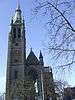
| St. Martin's church (nl) (fr) |
1907-1914 | Arlon | 49°40′58″N 5°48′33″E / 49.682656°N 5.809241°E |
81001-CLT-0040-01 Info |
 | |
| Synagogue (nl) (fr) |
Arlon | rue Saint Jean | 49°40′59″N 5°49′07″E / 49.683115°N 5.818718°E |
81001-CLT-0041-01 Info |
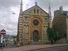 | |
| Old church of St. Martin and Gallo-Roman ruins (nl) (fr) |
Arlon | rue de Thermes | 49°40′51″N 5°49′02″E / 49.680738°N 5.817102°E |
81001-CLT-0042-01 Info |
 | |
| Center of the village of Guirsch (nl) (fr) |
Arlon | 49°43′03″N 5°51′07″E / 49.717552°N 5.851842°E |
81001-CLT-0043-01 Info |
.JPG) | ||
| parts of the building "Les Caves" <sup style="text-align:right; line-height:1em;
margin-left:0.3em; color:blue; cursor:help; font-family:Verdana,sans-serif;"
title="Sommige delen van de grotten met resten van schilderingen van het gebouw genaamd "Les Caves"">(nl) (fr) |
Arlon | 49°40′59″N 5°48′58″E / 49.682961°N 5.816242°E |
81001-PEX-0001-01 Info |
|||
| Church of St. Martin excepting the organ (nl) (fr) |
Arlon | 49°40′58″N 5°48′33″E / 49.682656°N 5.809241°E |
81001-PEX-0002-01 Info |
| ||
| Du Landbrough <sup style="text-align:right; line-height:1em;
margin-left:0.3em; color:blue; cursor:help; font-family:Verdana,sans-serif;"
title=""du Landbrough"">(nl) (fr) |
Arlon | 49°39′17″N 5°41′01″E / 49.654740°N 5.683657°E |
81001-PEX-0003-01 Info |
See also
| Wikimedia Commons has media related to Cultural heritage monuments in Arlon. |
References
- Belgian heritage register: Direction générale opérationnelle - Aménagement du territoire, Logement, Patrimoine et Energie (DG4)