List of stone circles in the Scottish Borders

Locations of well-preserved stone circles in the Scottish Borders.
This is a list of stone circles located in the Scottish Borders council area of Scotland. The Royal Commission on the Ancient and Historical Monuments of Scotland records 16 stone circles in the Scottish Borders. Of these, three are marked as 'possible'.[1] Aubrey Burl's gazetteer lists the same number: 2 in Berwickshire; 2 in Peebleshire; 10 in Roxburghshire; and 2 in Selkirkshire.[2]
The best preserved sites are the following:
- Borrowston Rig
- Burgh Hill
- Five Stanes
- Harestanes
- Ninestane Rig
- Yadlee
| Name | Image | Grid reference Coordinates |
Former county Parish |
Notes |
|---|---|---|---|---|
| Borrowston Rig | NT 5576 5231 55°45′44″N 2°42′23″W / 55.762151°N 2.70649°W |
Berwickshire
Lauder |
| |
| Burgh Hill | NT 4701 0624 55°20′50″N 2°50′13″W / 55.347361°N 2.837066°W |
Roxburghshire
Teviothead |
| |
| Cloyhouse Burn | NT 1795 3956 55°38′34″N 3°18′18″W / 55.64268°N 3.305066°W |
Peeblesshire
Stobo |
| |
| Five Stanes | 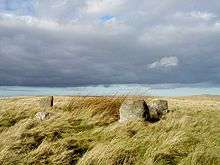 |
NT 7526 1686 55°26′42″N 2°23′33″W / 55.445025°N 2.392557°W |
Roxburghshire
Hownam |
|
| Five Stone Field | NT 7737 2922 55°33′22″N 2°21′37″W / 55.556185°N 2.360216°W |
Roxburghshire
Linton |
| |
| Harelaw, Fairnington | NT 66 28 55°32′57″N 2°31′57″W / 55.549043°N 2.532515°W |
Roxburghshire
Roxburgh |
| |
| Harestanes | 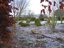 |
NT 1240 4432 55°41′04″N 3°23′41″W / 55.684468°N 3.394734°W |
Peeblesshire
Kirkurd |
|
| Harestanes Cottages | NT 64 24 55°30′47″N 2°33′49″W / 55.512961°N 2.563698°W |
Roxburghshire
Ancrum |
| |
| Kirktonhill | NT 470 543 55°46′46″N 2°50′45″W / 55.779557°N 2.845751°W |
Berwickshire
Channelkirk |
| |
| Megget Reservoir | NT 17904 21685 55°28′55″N 3°18′02″W / 55.482056°N 3.300557°W |
Selkirkshire
Yarrow |
| |
| Ninestone Rig | 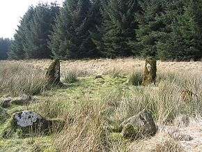 |
NY 5175 9731 55°16′03″N 2°45′39″W / 55.267615°N 2.760791°W |
Roxburghshire
Castleton |
|
| Oxnam Parish | NT 75 16 55°26′30″N 2°23′20″W / 55.441758°N 2.38881°W |
Roxburghshire
Oxnam |
| |
| Plenderleith | NT 740 118 55°24′00″N 2°24′41″W / 55.399901°N 2.411294°W |
Roxburghshire
Oxnam |
| |
| Redden | NT 7744 3790 55°38′03″N 2°21′35″W / 55.634179°N 2.35982°W |
Roxburghshire
Sprouston |
| |
| Stobo Mill | NT 1755 3700 55°37′11″N 3°18′38″W / 55.619617°N 3.310651°W |
Peeblesshire
Stobo |
| |
| Yadlee | NT 6540 6732 55°53′52″N 2°33′17″W / 55.897796°N 2.554795°W |
Berwickshire
Spott |
|
See also
References
- ↑ "Canmore Advanced Search: Stone Circle: Scottish Borders". Retrieved 2014-12-31.
- ↑ Burl, Aubrey (2000). The Stone Circles of Britain, Ireland and Brittany. New Haven; London: Yale University Press. p. 394.
- ↑ "Borrowston Rig | Canmore". canmore.org.uk. Retrieved 2015-07-11.
- ↑ "Burgh Hill | Canmore". canmore.org.uk. Retrieved 2015-07-11.
- ↑ "Cloyhouse Burn | Canmore". canmore.org.uk. Retrieved 2015-07-11.
- ↑ "Five Stanes | Canmore". canmore.org.uk. Retrieved 2015-07-11.
- ↑ "Five Stone Field | Canmore". canmore.org.uk. Retrieved 2015-07-11.
- ↑ "Harelaw, Fairnington | Canmore". canmore.org.uk. Retrieved 2015-07-11.
- ↑ "Harestanes | Canmore". canmore.org.uk. Retrieved 2015-07-11.
- ↑ "Harestanes Cottages | Canmore". canmore.org.uk. Retrieved 2015-07-11.
- ↑ "Kirktonhill | Canmore". canmore.org.uk. Retrieved 2015-07-11.
- ↑ "Megget Reservoir | Canmore". canmore.org.uk. Retrieved 2015-07-11.
- ↑ "Ninestone Rig | Canmore". canmore.org.uk. Retrieved 2015-07-11.
- ↑ "Oxnam Parish | Canmore". canmore.org.uk. Retrieved 2015-07-11.
- ↑ "Plenderleith | Canmore". canmore.org.uk. Retrieved 2015-07-11.
- ↑ "Redden | Canmore". canmore.org.uk. Retrieved 2015-07-11.
- ↑ "Stobo Mill | Canmore". canmore.org.uk. Retrieved 2015-07-11.
- ↑ "Yadlee | Canmore". canmore.org.uk. Retrieved 2015-07-11.
This article is issued from Wikipedia - version of the 11/12/2016. The text is available under the Creative Commons Attribution/Share Alike but additional terms may apply for the media files.