List of unused highways in Pennsylvania
The Schuylkill Parkway freeway stub in Bridgeport
An unused highway may reference a highway or highway ramp that was partially or fully constructed but was unused[1][2][3][4][5][6][7][8][9] or later closed.[10][11][12] An unused ramp can be referred to as a stub ramp,[13] stub street,[2][14][15] stub-out,[2] or simply stub.[16][17] The following is a list:
Pennsylvania
Bellefonte
- Pennsylvania Route 26 loses its 2-lanes freeway status after 1 mile past of the concurrency with Interstate 99, leaving a mainline stub at Pennsylvania Route 64 interchange. map
Breezewood
Main article: Abandoned Pennsylvania Turnpike
- A 13-mile section of the Pennsylvania Turnpike was bypassed in 1968 due to traffic congestion at the Rays Hill Tunnel and Sideling Hill Tunnel, both of which are located on the section. It is currently being incorporated into a bike trail. map
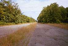
Bridgeport
- The abandoned remnants of the failed Schuylkill Parkway/Pennsylvania Route 23 expressway can be seen, with some elements of an interchange linking this expressway with U.S. Route 202 south (at the Dannehower Bridge) can be seen.[18][19]
Butler
- An incomplete cloverleaf exists near the western end of the U.S. Route 422 Butler Bypass. The interchange makes up the Pennsylvania Route 356 exit and mark the latter route's northern terminus. Grading and preliminary paving was done to all of the planned entrance and exit ramps before what was to extend north of the interchange was canceled and the exit was reconfigured.[20][21]
Clairton
- There are ramp stubs at the current northern terminus of Pennsylvania Route 43. Traffic is funneled onto the ramps of Exit 54 (Pennsylvania Route 51). If the Mon–Fayette Expressway is completed, these stubs will eventually carry the highway to Pittsburgh and Monroeville.[22] The project is now in the "Final Design" phase, which will be followed by right-of-way acquisition.[23][24] New funding became available in 2013 to potentially finish the project, but one of the northern legs is expected to be canceled altogether.[25]
Clarks Summit
- The Northeast Extension of the Pennsylvania Turnpike has a stub near its northern terminus. This stub was part of the original plan to connect the Northeast Extension to the New York state line.[26] After the passage of the Interstate Highway Act, plans to extend the toll road were abandoned. Currently, I-81 provides a direct connection from the northern terminus of Northeast Extension to New York.
Colver
- The northern end of U.S. Route 219's freeway section also ends in a stub near Colver. The highway transitions onto ramps that lead to and from Plank Road. Northbound U.S. 219 continues towards Carrolltown as an undivided road.[27]
Doylestown
- Both ends of the Doylestown Bypass (U.S. Route 202) had stubs. The east end is half of an unfinished diamond interchange.[28] The westbound end was a stub for the Federal Highway Administration-approved extension from PA 611 to Pennsylvania Route 63 in 1998 as an expressway. The Route 202 Parkway has replaced this stub end. Residents of Bucks County opposed the extension of U.S. 202 expressway northeast to New Hope such that the Pennsylvania Department of Transportation withdrew funding for the extension in 1977. There are no current plans to revive talks of the extension.[29]
East Cocalico Township
- Old exit 21 on Interstate 76/the Pennsylvania Turnpike was partially abandoned. Part of the interchange is used as a local overpass for Pepperidge Parkway, but the footprints of ramps are still visible.[30][31] Here is the old design.
Lancaster County
- A proposed extension of Pennsylvania Route 23 to be known as the "Lancaster-Norristown Expressway" was partially constructed to varying degrees, beginning in 1975. The project was killed in 1977.[32] The now-abandoned alignment is colloquially known as the "Goat Path".[33][34] The West end, ghost bridges, and a ghost interchange of the cancelled expressway all still exist. East of the interchange with Pennsylvania Route 772, the exact route is not clear.
Leechburg
- The Kiski Valley Expressway was to be an outer beltway of Pittsburgh but was cancelled like other Pennsylvania expressways due to the Pennsylvania Department of Transportation being near bankruptcy. Remnants of this exist at South Leechburg Hill Road, where traveling west on Pennsylvania Route 56, drivers are forced to exit onto South Leechburg Hill Road to continue on PA 56 and vice versa.[35][36]
Marshall Township, Allegheny County
- A stub exists on the exit ramp to U.S. Route 19 north from Interstate 79. This ramp was to connect with Brush Creek Drive and Thornhill Industrial Park. The ramp in use is the only direct connection I-79 north has to U.S. 19 north in the area.[22][37]
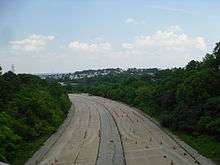
Morgantown
- Interstate 176, since its inception in 1963 (as Interstate 180), had never directly connected to its parent. Accessing I-176 required travelers to exit Interstate 76/the Pennsylvania Turnpike (former Interstate 80S) at Pennsylvania Route 10[38] and travel through Morgantown on PA 10 (part of which is a multiplex with Pennsylvania Route 23) to I-176.[39] This changed in 1996 when a direct connection was built to I-76/the Turnpike.[18] The PA 10 exit, a trumpet interchange, was abandoned but is still paved and is visible. The former terminus of I-176 is now a set of on-and off-ramps for PA 10 and PA 23.[18] Here is the old design and the new one and a close up of the abandoned trumpet. The part of the interchange north of the Turnpike has been removed for a parking lot that remains unused.
New Castle
- At what is now Exit 13 along Interstate 376 and U.S. Route 422 once had two off-ramps on I-376/U.S. 422 westbound, with one u-turn ramp ("13A") serving traffic to U.S. Route 224 west into Poland, Ohio while the other ramp ("13B") served traffic to U.S. 224 east into New Castle. (Before 2008, the interchange also served as the eastern terminus of U.S. 224.) "13B" was permanently closed on September 10, 2010 after "13A" was reconfigured for both directions of U.S. 224 and was simply labeled "13".[40]
Philadelphia
- At the interchange of Interstate 95 and the western approach to the Betsy Ross Bridge, stubs can be seen for the unbuilt Pulaski Expressway, intended to connect to the Roosevelt Expressway (old USGS Terraserver image, courtesy Alex Nitzman and construction in process ). Some have, in 1999, been rebuilt to connect local roads in the city's Port Richmond section.[41] However a stub still remains just prior to reaching Aramingo Avenue and is planned to extend to Torresdale Avenue via a connection to Adams Avenue. Construction was scheduled to begin in 2005.[42] Stubs also remain on the mainline of Pennsylvania Route 90 mainline headed north and on the Aramingo Avenue ramp from I-95 southbound. A bridge and some road which formerly connected Thompson Street to Luzerne Street remain. The bridge and the patch of road were put out of use after the ramps leading from northbound I-95 to the Betsy Ross Bridge and Adams Avenue were constructed, which was paved over the former street.
- South of the Benjamin Franklin Bridge, signs of the cancelled Crosstown Expressway (Interstate 695) exist as a wide median for exit 20. I-695 would have connected Interstate 95 at the Philadelphia International Airport with I-95 on the Delaware waterfront, bypassing the Philadelphia Sports Complex.[43][44][45]
- A freeway section of Pennsylvania Route 63 ends in a stub near an industrial area.[46] This freeway was originally intended to extend to the intersection of Byberry Road and Philmont Avenue in Lower Moreland Township and then later approved to connect to the Pennsylvania Turnpike/Interstate 276, linking the Turnpike with Interstate 95 (the Turnpike and I-95 have yet to directly connect). Budget problems have postponed the start of any project until at least 2010.[47]
Pittsburgh
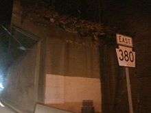
Ramp stub for 579 south to 380 east
- A small ramp stub, just east of Union Station, exists in the Interstate 579 and Pennsylvania Route 380/Bigelow Boulevard interchange. It is part of a ramp from I-579 south to PA 380 east that was never completed.[48][49][50] As the picture shows, there is extensive vegetation growth on the partially built ramp.
- North of Pittsburgh International Airport, there are ramp stubs at the interchange between Interstate 376 and Business Loop I-376. These are for the missing direct connections between I-376 and Business Loop I-376.[22][51]
- The Birmingham Bridge has stubs on the southern approaches to the bridge. These were to connect to the unbuilt Oakland Crosstown Freeway which was canceled by Pennsylvania Department of Transportation in the mid-1970s.[52] The bridge itself was built to hold the freeway.[53]
- The Industrial Highway was proposed and partially built in the 1960s and 1970s. It was to have run from Pennsylvania Route 60 north to Pennsylvania Route 51 but was only completed between Roswell Drive and Beechnut Drive.[54][55][56]
Ravine
- Interstate 81 just west of Ravine has unused ramps and parking areas for rest areas on both sides of the highway.[57]
Robinson Township
- Pennsylvania Route 576 has a mainline stub at the U.S. Route 22 interchange. This stub is eventually planned to take traffic to Interstate 79 and the Mon–Fayette Expressway, but construction on the extension is currently on hold due to funding limitations.[58] The Pennsylvania Turnpike Commission secured funding for the section to I-79 in 2012 and is expected to open in 2020,[59] while the section to the Mon–Fayette Expressway will be built at an undetermined date once the new funding sources from a 2013 transportation bill start trickling in.[25]
Selinsgrove, Pennsylvania
- U.S. Route 15 has mainline stubs where it meets U.S. Route 522 north of the city.[60] Northbound traffic is directed off before the bridge onto U.S. 522 to continue on U.S. 15. Traffic going south on U.S. 15 first crosses under the bridge and circles onto it by a cloverleaf interchange crossing the bridge. The highway continues past the bridge before dying off in the grass. There is also grading seen for more parts of the cloverleaf interchange.[61] Currently, there is a project to utilize the stubs. In 2003, the Central Susquehanna Valley Thruway project was approved and construction began in 2016. Extending the bypass is only part of this project, but it is set to be an expressway that ties into the Pennsylvania Route 147 expressway just across the Susquehanna River as well as an extension of Pennsylvania Route 61 to Sunbury.[62][63][64]
Somerset
- U.S. Route 219 has a stub at the southern end of its freeway. Southbound traffic exits just south of Somerset, where it can continue southward on the non-freeway Route 219. Meanwhile, an unused stub of the freeway continues half a mile from the exit.[65] PennDOT plans to upgrade the remaining sections of Route 219 to freeway to the Maryland border in coming years.[66]
Tinicum Township
- There are pylons and concrete foundations which formerly carried aerial ramps to the departure terminal entrances at Philadelphia International Airport. In 2002, these ramps were replaced by an at-grade approach, fed by newer ramps which provide access to both northbound and southbound Interstate 95. In 2006, Pennsylvania Route 291 was rerouted to use Bartram Avenue and Island Avenue around the airport instead of the old Industrial Highway alignment due to runway expansion at the airport. Much of the original alignment has been repurposed for other uses, such as parking lots and the cell phone waiting lot, leaving several stubs and strips of empty pavement in between.
See also
 U.S. Roads portal
 Pennsylvania portal
- List of ghost towns in Pennsylvania
References
- ↑ "US&R and NY-TF1 Practice for the Real Thing." City of New York 20 June 2005. 15 Jan. 2007 .
- 1 2 3 "Kentucky Model Access Management Ordinance." Kentucky Transportation Cabinet Oct. 2004. 15 Jan. 2007 .
- ↑ "Barrie (City) v. 1606533 Ontario Inc.", 2005 CanLII 24746 (ON S.C.). 15 Jan. 2007 .
- ↑ Iowa House. 1998. House File 686., 77th, H.R. 0686. .
- ↑ "PETITIONED PUBLIC HEALTH ASSESSMENT." New York City. 15 Jan. 2007 .
- ↑ House. 1993. LAND TITLE AMENDMENT ACT, 1993. 35th Parliament, 2nd sess., H.R. 78. .
- ↑ Munroe, Tapan. "TRENDS ANALYSIS for PARKS & RECREATION: 2000 AND BEYOND." California Park & Recreation Society Jan. 1999. 15 Jan. 2007
- ↑ "Chapter 5: Detailed Comparison of Alternatives – Seattle." SR 520 Bridge Replacement and HOV Project, Washington Department of Transportation, 2 May. 2005. 15 Jan. 2007 .
- ↑ Anderson, Steve. "CT 11 Expressway." New York City Roads. 15 Jan. 2007 .
- ↑ "Leasing of Closed Highways Regulation", Alta. Reg. 36/1986. 15 Jan. 2007 .
- ↑ "R. v. Sanders", 2004 NBPC 12 (CanLII). 15 Jan. 2007 .
- ↑ "HIGHWAY CLOSINGS", R.R.O. 1990, Reg. 599. 15 Jan. 2007 .
- ↑ "Washington State Department of Transportation Public Transportation and Rail Division Monthly News, October 2006, page 4" (PDF). (286 KiB), accessed December 28, 2006
- ↑ Sommer, Dick. "Ten Ways to Manage Roadway Access in Your Community." Ohio Department of Transportation, 2005. 15 Jan. 2007 .
- ↑ Bauserman, Christian E. "DELAWARE COUNTY ENGINEER’S DESIGN, CONSTRUCTION & SURVEYING STANDARDS." 18 May 1998. 15 Jan. 2007 .
- ↑ Geiger, Gene. "Ohio DOT Constructs I-670 over a Water Treatment Sludge Lagoon in Columbus." Ohio LTAP Quarterly. Ohio Department of Transportation. 15:3 (1999) .
- ↑ "CITY OF UNION, KENTUCKY." City of Union, Kentucky 23 June 2006. 15 Jan. 2007 .
- 1 2 3 "Pennsylvania 23". AARoads.
- ↑ https://maps.google.com/maps?f=q&hl=en&q=marietta,+pa&layer=&ie=UTF8&om=1&z=16&ll=40.105633,-75.353379&spn=0.007681,0.021544&t=h&iwloc=addr
- ↑ Prince, Adam. "PA State Route 356 Ends".
- ↑ http://msrmaps.com/image.aspx?T=1&S=11&Z=17&X=1470&Y=11314&W=2&qs=%7cbutler%7cpa%7c
- 1 2 3 Prince, Adam. "Pennsylvania Ghost Ramps".
- ↑ "Mon/Fayette & Southern Beltway Projects-51 to 376C".
- ↑ http://www.google.com/maps?ie=UTF8&ll=40.292817,-79.913177&spn=0.013814,0.029182&t=h&z=15&om=1
- 1 2 http://triblive.com/neighborhoods/yourmonvalley/yourmonvalleymore/5210956-74/expressway-transportation-law#axzz2n08KHEig
- ↑ http://www.pahighways.com/toll/PATurnpike.html
- ↑ https://maps.google.com/maps?q=somerset,+pa&hl=en&ll=40.553608,-78.718929&spn=0.008983,0.023797&sll=40.564547,-78.707428&sspn=0.067551,0.190372&vpsrc=6&gl=us&t=h&z=16
- ↑ https://maps.google.com/maps?f=q&hl=en&q=doylestown,+pa&ie=UTF8&ll=40.312274,-75.108976&spn=0.007183,0.021458&t=h&om=1
- ↑ Anderson, Steve. "US 202 Expressway (Pennsylvania)". phillyroads.com.
- ↑ "Topographic map 4 km E of Reamstown, Pennsylvania, United States 7/1/1992". USGS via Microsoft Research Maps.
- ↑ https://maps.google.com/maps?f=q&hl=en&geocode=&time=&date=&ttype=&q=40.221457+-76.090837&ie=UTF8&ll=40.221887,-76.090912&spn=0.00408,0.007296&t=k&z=17&om=1
- ↑ Kitsko, Jeffrey. "Lancaster-Norristown Expressway (Cancelled)". Harrisburg Highways.
- ↑ "Harrisburg Road Enthusiast Meet 2004". AARoads.
- ↑ Kitsko, Jeffrey. "PA 1 - 50". Pennsylvania Highways.
- ↑ Kitsko, Jeffrey. "Kiski Valley Expressway".
- ↑ http://www.google.com/maps?ie=UTF8&t=k&om=1&ll=40.614083,-79.617577&spn=0.012836,0.029182&z=15
- ↑ https://maps.google.com/maps?f=q&hl=en&q=marshall+township,+pa&layer=&sll=37.0625,-95.677068&sspn=30.268266,59.765625&ie=UTF8&z=18&ll=40.666573,-80.095026&spn=0.001766,0.005407&t=k&om=1
- ↑ "3-digit Interstates from I-76". kurumi.
- ↑ Kitsko, Jeffrey. "Morgantown Expressway". Pennsylvania Highways.
- ↑ https://www.google.com/maps/preview#!q=Interstate+376%2C+New+Castle%2C+Union%2C+PA&data=!1m4!1m3!1d5236!2d-80.3923531!3d41.0098156!2m1!1e3!4m15!2m14!1m13!1s0x88347e211a88443d%3A0xa346552a550f4c0!3m8!1m3!1d149!2d-79.9153776!3d40.2895271!3m2!1i1280!2i666!4f35!4m2!3d41.0091885!4d-80.3915841&fid=7
- ↑ Anderson, Steve. "Pulaski Expressway (PA 90, unbuilt)". phillyroads.com.
- ↑ Anderson, Steve. "Delaware Expressway (I-95)". phillyroads.com.
- ↑ Scott, Kozel. "Interstate 695". kurumi.
- ↑ Kitsko, Jeffrey. "Pennsylvania's Dearly Departed Interstates". Pennsylvania Highways.
- ↑ https://maps.google.com/?ie=UTF8&om=1&t=h&ll=39.939365,-75.143073&spn=0.003241,0.007296&z=17
- ↑ https://maps.google.com/maps?ll=40.112296,-75.001377&spn=0.004677,0.010782&t=k
- ↑ Anderson, Steve. "Woodhaven Road (PA 63)". phillyroads.com.
- ↑ Prince, Adam. "Ghost Ramp I-579 @ Bigelow". The SWPA Roads Project.
- ↑ "Interstate 579-Crosstown Boulevard". Pennsylvania Highways.
- ↑ http://www.google.com/maps?hl=en&ll=40.44502,-79.98976&spn=0.000004,0.005949&t=h&om=1&z=18&vpsrc=6&layer=c&cbll=40.44494,-79.989882&panoid=_ZuO4inpTxaGXvkYTb8jIA&cbp=12,111.35,,0,-5.6
- ↑ http://local.live.com/default.aspx?v=2&cp=40.516232~-80.270648&style=a&lvl=15
- ↑ Kitsko, Jeffrey. "Oakland Crosstown Freeway".
- ↑ https://maps.google.com/maps?f=q&hl=en&layer=&ie=UTF8&z=18&ll=40.430354,-79.97364&spn=0.002021,0.005386&t=k&om=1
- ↑ Prince, Adam. "The Industrial Highway".
- ↑ http://www.google.com/maps?f=q&hl=en&geocode=&ie=UTF8&t=h&om=1&ll=40.449731,-80.087607&spn=0.003217,0.007296&z=17&iwloc=addr
- ↑ http://www.google.com/maps?f=q&hl=en&geocode=&ie=UTF8&t=h&om=1&ll=40.441746,-80.08323&spn=0.003217,0.007296&z=17&iwloc=addr
- ↑ 40°34'17.0"N 76°25'00.0"W - Google Maps
- ↑ https://maps.google.com/maps?q=somerset,+pa&hl=en&ll=40.429113,-80.315466&spn=0.017836,0.047593&sll=40.564547,-78.707428&sspn=0.067551,0.190372&vpsrc=6&gl=us&t=h&z=15
- ↑ Gillooly, Amanda. (2012-12-21) Turnpike Commission to Proceed With Beltway Project, Lawmakers Laud the Move - Government - Canon-McMillan, PA Patch. Canon-mcmillan.patch.com. Retrieved on 2013-07-23.
- ↑ Nitzman, Alex. "US 11/US 15 Selinsgrove Bypass". Pennsylvania Highways.
- ↑ http://www.wikimapia.org/#lat=40.818421&lon=-76.853013&z=15&l=0&m=h&v=2
- ↑ Kitsko, Jeffrey. "US 15". Pennsylvania Highways.
- ↑ "Central Susquehanna Valley Transportation Project". Pennsylvania Department of Transportation.
- ↑ http://www.csvt.com/assets/maps/recomended%20alternative.pdf
- ↑ Satellite image of Somerset Route 219 stub
- ↑ U.S. 219 - Paving the Way
External links
- Unsung Monuments in "The Monument City" - photographic essay of Baltimore area stubs
This article is issued from Wikipedia - version of the 11/17/2016. The text is available under the Creative Commons Attribution/Share Alike but additional terms may apply for the media files.