Listed buildings in Henhull
Henhull is a civil parish in Cheshire East, England. It contains four buildings that are recorded in the National Heritage List for England as designated listed buildings, all of which are at Grade II. This grade is the lowest of the three gradings given to listed buildings and is applied to "buildings of national importance and special interest".[1] The parish contains no major settlements, and is almost entirely rural. The Shropshire Union Canal passes through the parish. All the listed buildings are close to the entrance of its Nantwich Basin, and consist of a bridge, a lock gate, a milepost, and a cottage.
| Name and location | Photograph | Date | Notes |
|---|---|---|---|
| Basin End 53°04′19″N 2°32′24″W / 53.07188°N 2.53993°W |
 |
Early 19th century | A brick cottage with a slate roof. It is in two storeys with a two-bay front and a single-bay lean-to extension. The left bay projects forward and is gabled. It contains a round-headed doorway. The windows in the ground floor are horizontal sliding sashes and in the upper floor are casements.[2] |
| Nantwich Junction Bridge 53°04′20″N 2°32′23″W / 53.07233°N 2.53967°W |
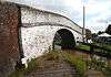 |
c. 1826 | This is bridge no. 92 over the Shropshire Union Canal. It is a roving bridge carrying the towpath over the canal at the entry to Nantwich Basin. The bridge is built in brick with stone quoins, parapets, and pier caps. It is a humped skew bridge with a single arch, and there are cast iron rubbing posts at the angles of the arch.[3] |
| Lock gate, Nantwich Junction Bridge 53°04′21″N 2°32′23″W / 53.07237°N 2.53974°W |
— |
c. 1826 | This is a single wooden lock gate. It is used for drainage, and when closed separates Nantwich Aqueduct from Nantwich Basin End and the northern section of the canal.[4] |
| Milepost 53°04′21″N 2°32′23″W / 53.07245°N 2.53967°W |
— |
c. 1826 | The milepost is in cast iron and has a domed top. It is 60 centimetres (24 in) high and 15 centimetres (6 in) in diameter. It carries a T-shaped plate divided into three parts which contain "NANTWICH" and the distances in miles to Autherley Junction and Norbury Junction.[5] |
References
Citations
Sources
- Historic England, "Basin End, Henhull (1330140)", National Heritage List for England, retrieved 25 January 2014
- Historic England, "Nantwich Junction Bridge, Henhull (1136456)", National Heritage List for England, retrieved 25 January 2014
- Historic England, "Lock gate north side of Nantwich Junction Bridge, Henhull (1138542)", National Heritage List for England, retrieved 25 January 2014
- Historic England, "Canal mile post by Nantwich Junction Bridge, Henhull (1138543)", National Heritage List for England, retrieved 25 January 2014
- Historic England, Listed Buildings, retrieved 1 April 2015
This article is issued from Wikipedia - version of the 10/20/2015. The text is available under the Creative Commons Attribution/Share Alike but additional terms may apply for the media files.