Little Missouri River (North Dakota)
| Little Missouri River | |
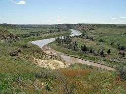 Flowing through Theodore Roosevelt National Park | |
| Country | United States |
|---|---|
| States | Wyoming, Montana, South Dakota, North Dakota |
| Source | Flatiron Butte |
| - location | near Oshoto, Crook County, Wyoming |
| - elevation | 4,501 ft (1,372 m) [1] |
| - coordinates | 44°32′25″N 104°59′57″W / 44.54028°N 104.99917°W [2] |
| Mouth | Missouri River[3] |
| - location | Lake Sakakawea, near Killdeer, Dunn County, North Dakota |
| - elevation | 1,860 ft (567 m) [2] |
| - coordinates | 47°36′38″N 102°52′24″W / 47.61056°N 102.87333°WCoordinates: 47°36′38″N 102°52′24″W / 47.61056°N 102.87333°W [2] |
| Length | 560 mi (901 km) [4] |
| Basin | 8,310 sq mi (21,523 km2) [5] |
| Discharge | for 17.5 miles (28.2 km) south of Watford City, about 25 miles (40 km) from the mouth |
| - average | 534 cu ft/s (15 m3/s) [6] |
| - max | 110,000 cu ft/s (3,115 m3/s) |
| - min | 0 cu ft/s (0 m3/s) |
 Little Missouri watershed | |
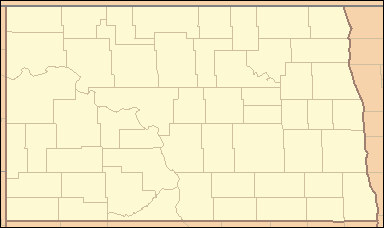 Location of the mouth of the Little Missouri River in North Dakota | |
The Little Missouri River is a tributary of the Missouri River, 560 miles (901 km) long, in the northern Great Plains of the United States.[4] Rising in northeastern Wyoming, in western Crook County about 15 miles (24 km) west of Devils Tower,[7] it flows northeastward, across a corner of southeastern Montana, and into South Dakota. In South Dakota, it flows northward through the Badlands into North Dakota, crossing the Little Missouri National Grassland and both units of Theodore Roosevelt National Park. In the north unit of the park, it turns eastward and flows into the Missouri in Dunn County at Lake Sakakawea, where it forms an arm of the reservoir 30 miles (48 km) long called Little Missouri Bay and joins the main channel of the Missouri about 25 miles (40 km) northeast of Killdeer.[8]
The highly seasonal runoff from badlands and other treeless landscapes along the Little Missouri carries heavy loads of eroded sediment downstream.[9] The sedimentary layers, which extend from the headwaters in Wyoming all the way to the mouth in North Dakota, vary in age, but most of the beds along the river belong to the Bullion Creek and Sentinel Butte formations, both deposited during the Paleocene (about 66 to 56 million years ago).[10] The deposits include siltstone, claystone, sandstone, and lignite coal laid down in a coastal plain during the Laramide orogeny.[10]
See also
- List of rivers of North Dakota
- List of longest rivers of the United States (by main stem)
- List of rivers of Montana
- List of rivers of South Dakota
- List of rivers of Wyoming
- Montana Stream Access Law
References
- ↑ Source elevation derived from Google Earth search using GNIS source coordinates.
- 1 2 3 "Little Missouri River". Geographic Names Information System. United States Geological Survey. February 13, 1980. Retrieved April 26, 2011.
- ↑ Federal Writers' Project (1940). South Dakota place-names, v.3. University of South Dakota. p. 4.
- 1 2 Personius, Robert Giles; Eddy, Samuel (February 18, 1955). "Fishes of the Little Missouri River". Copeia. American Society of Ichthyologists and Herpetologists. 1955 (1): 41. doi:10.2307/1439450.
- ↑ "USGS 06337000 Little Missouri River near Watford City, ND". November 2010. Retrieved April 27, 2011. This is only a close approximation of the entire basin. It does not include a small fraction of the basin below the river gauge, located about 25 mi (40 km) upstream of the river mouth.
- ↑ "USGS 06337000 Little Missouri River near Watford City, ND". November 2010. Retrieved April 27, 2011. This is the average discharge for the years 1990–2010, derived by adding the discharge for each of these years and dividing by 21.
- ↑ Wyoming Atlas & Gazetteer (Map) (6th ed.). DeLorme. 2009. § 19. ISBN 0-89933-338-9.
- ↑ The Road Atlas (Map). Rand McNally & Company. 2008. § 61, 77. ISBN 978-0-528-93961-7.
- ↑ "Little Missouri River Description". United States Geological Survey. December 31, 2007. Retrieved April 27, 2011.
- 1 2 Bluemle, John P. "North Dakota Notes #12: North Dakota's Badlands". North Dakota Geological Survey. Retrieved April 27, 2011.
External links
- Wyoming State River Plan: Little Missouri River
- The Lewis and Clark Trail: The Little Missouri River
- National Park Service: North Dakota Segments
| Lists |  | |
|---|---|---|
| Geography | ||
| Native American tribes | ||
| History | ||
| Engineering | ||
| Parks and preserves | ||