Lituya Bay
| Lituya Bay | |
|---|---|
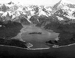 Oblique aerial photograph of Lituya Bay in the Summer of 1958. Damage from the 1958 megatsunami appears as the lighter-colored areas on the shores where trees have been stripped away. | |
| Location | North Pacific Ocean |
| Coordinates | 58°38′13″N 137°34′23″W / 58.63694°N 137.57306°WCoordinates: 58°38′13″N 137°34′23″W / 58.63694°N 137.57306°W |
| River sources |
Lituya Glacier Cascade Glacier Crillion Glacier |
| Basin countries | United States |
| Max. length | 14.5 km (9.01 mi) |
| Max. width | 3.2 km (1.99 mi) |
Lituya Bay (/lᵻˈtjuːjə/; Tlingit: Ltu.aa,[1] meaning "Lake Within the Point"[2]) is a fjord located on the coast of the Southeast part of the U.S. state of Alaska. It is 14.5 km (9.0 mi) long and 3.2 km (2.0 mi) wide at its widest point. The bay was noted in 1786 by Jean-François de La Pérouse, who named it Port des Français. Twenty-one of his men perished in the tidal current in the bay.
Description
The smaller Cascade and Crillon Glaciers and the larger Lituya Glacier all spill into Lituya Bay, which is a part of Glacier Bay National Park and Preserve. Cenotaph Island is located roughly in the middle of the bay. The entrance of the bay is approximately 500 m (0.31 mi) wide, with a narrow navigable channel.[3]
The bay is known for its high tides, which have a range of approximately 3 m (9.8 ft). Tidal currents in the entrance reach 9.4 km/h (5.1 kn). The entrance is considered dangerous to navigation, especially when the tidal currents are running, but the interior of the bay provides good protection to anchored ships.[3]
Lituya Bay is also famous for four recorded tsunamis, in 1854, 1899, 1936, and 1958.[4][5]
1958 megatsunami
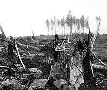
The same topography that leads to the heavy tidal currents also created the highest wave from a tsunami in recorded history. On July 9, 1958, an earthquake caused a landslide in the Gilbert Inlet at the head of the bay, generating a massive megatsunami measuring between 100 ft (30 m) and 300 ft (91 m). The subsequent breaking wave possessed sufficient power to snap off all the trees up to 1,720 feet (520 m) high on the slope directly opposite the landslide. There were three fishing boats anchored near the entrance of Lituya Bay on the day the giant wave occurred. One boat sank and the two people on board were killed. The other two boats were able to ride the waves. Among the survivors were William A. Swanson and Howard G. Ulrich, who provided accounts of what they observed. Based on Swanson's description of the length of time it took the wave to reach his boat after overtopping Cenotaph Island near the bay's entrance, the wave may have been traveling 120 mph. When it reached the open sea, however, it dissipated quickly. This incident was the first direct evidence and eyewitness report of the existence of megatsunamis.[4]
See also
| Wikimedia Commons has media related to Lituya Bay megatsunami. |
References
- Guinness World Records Ltd. (2005). Guinness World Records 2006: 84.
- Mega-tsunami: Wave of Destruction. Horizon. BBC Two 12 October 2000
- ↑ Teben'kov, M.D.; Translated by R.A. Pierce (1981) [1852], Atlas of the Northwest Coasts of America: From Beering Strait to Cape Corrientes and the Aleutian Islands with Several Sheets on the Northeast Coast of Asia, Kingston, Ontario: Limestone Press, p. 27, ISBN 0-919642-55-1. Spelled L'tua in translation of Tebenkov's log.
- ↑ Emmons, G. T. (1 April 1911). "Native Account of the Meeting between La Perouse and the Tlingit". American Anthropologist. 13 (2): 294–98. JSTOR 659650.
- 1 2 United States Coast Pilot 9. p. 130.
- 1 2 "Don J. Miller, Giant Waves in Lituya Bay, Alaska". Uwsp.edu. Retrieved 2013-12-03.
- ↑ Casey, Susan. The Wave. Doubleday, 2010, pp. 153-158
External links
- E. W. Eickelberg, Lituya Bay, Gulf of Alaska. U.S. Coast and Geodetic Survey FIELD ENGINEERS BULLETIN no. 10, December 1936
- World's Biggest Tsunami: The largest recorded tsunami with a wave 1,720 feet (520 m) tall in Lituya Bay, Alaska
- Photos of damage from the 1958 tsunami
- Eyewitness reports of the tsunami
- History of Lituya Bay, Tsunami and Laperouse (in French)
- Giant Waves in Lituya Bay, Alaska; USGS PP 354-C