Loch Lomond
| Loch Lomond | |
|---|---|
|
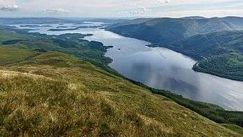
Loch Lomond, looking south from Ben Lomond | |
| Location | West Dunbartonshire/Argyll and Bute/Stirling, Scotland |
| Coordinates | 56°05′N 4°34′W / 56.083°N 4.567°WCoordinates: 56°05′N 4°34′W / 56.083°N 4.567°W |
| Type | freshwater loch, ribbon lake, dimictic |
| Primary inflows | Endrick Water, Fruin Water, River Falloch |
| Primary outflows | River Leven |
| Catchment area | 696 km2 (269 sq mi) |
| Basin countries | Scotland |
| Max. length | 24 mi (39 km) |
| Max. width | 5 mi (8.0 km) |
| Surface area | 27 sq mi (70 km2) |
| Average depth | 121 ft (37 m) |
| Max. depth | 620 ft (190 m) |
| Water volume | 0.62 cu mi (2.6 km3) |
| Residence time | 1.9 years |
| Surface elevation | 25 ft (7.6 m) |
| Islands | 60 (Inchcailloch, Inchmurrin, Inchfad) |
| Sections/sub-basins | north basin, south basin |
| Settlements | Balloch, Ardlui, Balmaha, Luss, Rowardennan, Tarbet |
| Designated | 5 January 1976 |
Loch Lomond (/ˈlɒx ˈloʊmənd/; Scottish Gaelic: Loch Laomainn) is a freshwater Scottish loch which crosses the Highland Boundary Fault. It is the largest inland stretch of water in Great Britain by surface area.[1] The loch contains many islands, including Inchmurrin, the largest fresh-water island in the British Isles.[2] Loch Lomond is a popular leisure destination and is featured in the song "The Bonnie Banks o' Loch Lomond". The Loch is now part of the Loch Lomond and The Trossachs National Park which was established in 2002. Loch Lomond is a corruption of the Gaelic Lac Leaman, or 'Lake of the Elms'.[3]
Geography
Loch Lomond is a freshwater loch lying on the Highland Boundary Fault, often considered the boundary between the lowlands of Central Scotland and the Highlands. It is 24 miles (39 km) long and between 3⁄4 and 5 miles (1.2 and 8.0 km) wide. It has an average depth of about 121 feet (37 m), and a maximum depth of about 620 feet (190 m). Its surface area is 27 sq mi (70 km2), and it has a volume of 0.62 cu mi (2.6 km3). Of all lochs and lakes in Great Britain, it is the largest by surface area, and the second largest (after Loch Ness) by water volume.[4] Within the United Kingdom, it is surpassed only by Lough Neagh and Lough Erne in Northern Ireland[5] and regarding the British Isles as a whole there are also several larger loughs in the Republic of Ireland.
Traditionally a boundary between Stirlingshire and Dunbartonshire, Loch Lomond is currently split between the council areas of Stirling, Argyll and Bute, and West Dunbartonshire. Its southern shores are about 14 miles (23 km) north of Glasgow, Scotland's largest city.
Loch Lomond is now part of Loch Lomond and the Trossachs National Park. Ben Lomond is on the eastern shore: 3,195 feet (974 m) in height and the most southerly of the Scottish Munro peaks. A 2005 poll of Radio Times readers voted Loch Lomond as the sixth greatest natural wonder in Britain.[6]
The main arterial route along the loch is the A82 road which runs the length of its western shore. For a long time this was a notorious bottleneck, with the route clogged with tourists during the summer months. It was upgraded in the 1980s and 1990s, although the stretch north of Tarbet remains unimproved.
Islands

The loch contains thirty or more other islands,[7][Note 1] depending on the water level. Several of them are large by the standards of British bodies of freshwater. Inchmurrin, for example, is the largest island in a body of freshwater in the British Isles.[2] As in Loch Tay, several of the islands appear to be crannogs, artificial islands built in prehistoric periods.
English travel writer, H.V. Morton wrote:
What a large part of Loch Lomond's beauty is due to its islands, those beautiful green tangled islands, that lie like jewels upon its surface.[13]
One of the loch's islands, Inchconnachan, is home to a colony of wallabies.[14]
Leisure activities
The Loch Lomond Golf Club is situated on the south western shore. It has hosted many international events including the Scottish Open. Another golf club, "The Carrick" has opened on the banks of the Loch adjacent to the Loch Lomond Club.[15] The West Highland Way runs along the eastern bank of the loch. The West Loch Lomond Cycle Path runs from Arrochar and Tarbet railway station, at the upper end of the loch, to Balloch railway station, at the south end. The 17-mile-long (28 km) long cycle path runs along the west bank.
At the south end of the loch near Balloch is a large visitor and shopping complex named Loch Lomond Shores. This was the venue for the Great Scottish Swim in 2013.
Boating and watersports
Loch Lomond is one of Scotland's premier boating and watersports venues and the scenery draws people from all over Scotland and beyond. The loch is open to every kind of watercraft including kayaks, canoes, wind-surfers, jetskis, speedboats and cruisers and they are all very well represented. Loch Lomond Rescue Boat provides 24-hour safety cover on the loch. The Rescue Boat is a Volunteer Organisation and a Registered Charity. The National Park Authority also have other boats on the Loch such as The Brigadier. Strathclyde Police also operate on the Loch using RIBs and Jet Skis and work in conjunction with the National Park Authority.

The National Park Authority has tried to achieve a balance between land-based tourists and loch users, with environmentally sensitive areas subject to a strictly enforced 10 km/h (5.4 kn; 6.2 mph) speed limit, but the rest of the loch open to speeds of up to 90 km/h (49 kn; 56 mph).
Other leisure activities on the loch include cruises from the town of Balloch, operated by Sweeney's Cruises.[16]
The Maid of the Loch was the last paddle steamer built in Britain. Built on the Clyde in 1953, she operated on Loch Lomond for 29 years. She is now being restored at Balloch pier by the Loch Lomond Steamship Company, a charitable organisation, supported by West Dunbartonshire Council.[17]
Guided canoeing and canoe hire is available through some small companies such as SD Adventures[18]
Air crash
On 22 April 1940 a British Overseas Airways Corporation Lockheed Model 14 Super Electra (Loch Invar, registration G-AFKD) flying from Perth Airport (Scotland) to Heston Aerodrome in London crashed at Loch Lomond, killing all five passengers and crew.[19]
In popular culture
Jan2000.jpg)
The song
The loch is featured in a well-known song which was first published around 1841.[20] The chorus is:
- Oh, ye'll tak the high road, and I'll tak the low road,
- And I'll be in Scotland afore ye;
- But me and my true love will never meet again
- On the bonnie, bonnie banks o' Loch Lomond.
The song has been recorded by many performers over the years, including jazz singer Maxine Sullivan (for whom it was a career-defining hit), the Mudmen, Scottish-Canadian punk band The Real McKenzies. Both Runrig and Quadriga Consort used to perform Loch Lomond as their concert's final song. The original author is unknown. One story is that the song was written by a Scottish soldier who awaited death in enemy captivity; in his final letter home, he wrote this song, portraying his home and how much he would miss it. Another tale is that during the 1745 Rebellion a soldier on his way back to Scotland during the 1745–46 retreat from England wrote this song. The "low road" is a reference to the Celtic belief that if someone died away from his homeland, then the fairies would provide a route of this name for his soul to return home.[21] Within this theory, it is possible that the soldier awaiting death may have been writing either to a friend who was allowed to live and return home, or to a lover back in Scotland.
Other
- Loch Lomond (like Loch Ness) is often used as a shorthand for all things Scottish, an image partly reinforced by the eponymous song. An archetype is the Lerner and Loewe musical Brigadoon. The opening lyrics of the song "Almost Like Being in Love" are: "Maybe the sun gave me the power/For I could swim Loch Lomond and be home in half an hour/Maybe the air gave me the drive/For I'm all aglow and alive!"
- It is mentioned in the song "You're All the World to Me" from the musical film Royal Wedding in the line: "You're Loch Lomond when autumn is the painter!"
- The village of Luss ("Glendarroch") on the shores of the loch was the location for the TV soap Take the High Road, and the loch itself was given the fictional name Loch Darroch for the purpose of the series. Luss ("Lios") and the islands nearby were used as the setting for E. J. Oxenham's first book, Goblin Island, published in 1907.[22]
- Loch Lomond is also the brand name of the Scotch whisky drunk by Captain Haddock in Hergé's comic book series The Adventures of Tintin. It is produced at the Loch Lomond distillery.
- Loch Lomond is the opening track on guitarist Steve Hackett's 2011 album Beyond the Shrouded Horizon.
- In The Three Stooges episode "Pardon My Scotch" a gentleman asks 'Are you laddies by any chance from Loch Lomond?', whereupon Curly replies 'No we're from lock jaw'.
- One of the road signs in the Merrie Melodies short "My Bunny Lies over the Sea" points to Loch Lomond.
- Spike Milligan created an episode of The Goon Show entitled The Treasure of Loch Lomond. The main character, Neddie Seagoon, discovers he has Scottish heritage and travels to Scotland to claim a fortune owned by his uncle, who discovered a galleon full of treasure at the bottom of the loch.
- In The Mel Brooks movie Spaceballs, the character "Snotty" delivers the line "Lock one... lock two... lock three... Loch Lomond..." while locking transporters onto "President Skroob".
- In Santa Cruz County, California, United States lies Loch Lomond, a small body of water named after Loch Lomond in Scotland. Near Loch Lomond, California is Ben Lomond which was named by Scot John Burns in 1851.
- Loch Lomond features as the backdrop for a song sequence in the 1998 Bollywood film Kuch Kuch Hota Hai.[23][24]
See also
- List of freshwater islands in Scotland
- List of lochs in Scotland
- Inverarnan Canal - a short waterway that once allowed Loch Lomond steamers to reach Inverarnan.
References and footnotes
- Notes
- Citations
- ↑ Peter Matthews, ed. (1994). The Guinness Book of Records 1995. Guinness World Records Limited. p. 17. ISBN 0-85112-736-3.
- 1 2 Worsley, Harry (1988). Loch Lomond: The Loch, the Lairds and the Legends. Glasgow: Lindsay Publications. ISBN 978-1-898169-34-5.
- ↑ Richens, R. J. (1984) Elm, Cambridge University Press.
- ↑ "Scotland’s Water Environment Review 2000–2006" SEPA. Retrieved 11 October 2008.
- ↑ Whitaker's Almanack (1991) London. J. Whitaker and Sons. p. 127.
- ↑ "Caves win 'natural wonder' vote" BBC.co.uk Retrieved 10 December 2006.
- ↑ "Loch Lomond Islands – Inchmurrin". Loch Lomond.net. Retrieved 23 August 2007.
- ↑ "Loch Lomond Islands" loch-lomond.me.uk. Retrieved 23 January 2010.
- ↑ "Introduction to Loch Lomond Islands". Loch Lomond, Callander and Trossachs. Retrieved 25 September 2008.
- ↑ For example, "Loch lomond" goxplore.net Retrieved 29 April 2010.
- ↑ "The Loch" Loch Lomond.net. Retrieved 23 January 2010.
- ↑ "The islands on Loch Lomond " visit-lochlomond.com. Retrieved 28 April 2010.
- ↑ Morton, H. V. In Scotland Again (1933), Methuen London – p145
- ↑ Scottish Daily Record, 06/06/2009 Colony of Wallabies set for cull
- ↑ "The Carrick Visit Scotland. Retrieved 10 October 2008.
- ↑ "Cruise Loch Lomond" (video). Scotland on TV. Retrieved 25 September 2008.
- ↑ "Maid of the Loch". Loch Lomond Steamship Company. Retrieved 25 September 2008.
- ↑ S D ADVENTURES- Winter skills, Navigation, Climbing, Canoeing, - Home
- ↑
- ↑ James J. Fuld, The Book of World-Famous Music: Classical, Popular and Folk, p. 336.
- ↑ Fraser, Amy Stewart (1977). In Memory Long. Routledge. p. 54. ISBN 978-0-7100-8586-3. Retrieved 10 October 2008.
- ↑ Elsie J. Oxenham, Goblin Island, Collins (1907), p. 58.
- ↑ "Wealth of fans to locate". The Scotsman. 28 September 2002. Retrieved 27 December 2015.
- ↑ "Ticket tout fears over Bollywood star". The Scotsman. 8 August 2002. Retrieved 27 December 2015.
External links
| Wikimedia Commons has media related to Loch Lomond. |
| Wikivoyage has a travel guide for Loch Lomond. |
- Loch Lomond & The Trossachs National Park
- Loch Lomond walking routes
- Robert Burns (poet): links to Loch Lomond
- Loch Lomond webcam
- The islands of Loch Lomond
- The Loch Lomond Association
- Boating information for Loch Lomond
- Loch Lomond Distillery
- Loch Lomond Sailing Club History