Lock and Dam No. 2
 Mississippi River Lock and Dam No. 2 | |
| Location | Hastings, Dakota County / Denmark Township, Washington County, near Hastings, Minnesota |
|---|---|
| Coordinates | 44°45′35″N 92°52′07″W / 44.75972°N 92.86861°WCoordinates: 44°45′35″N 92°52′07″W / 44.75972°N 92.86861°W |
| Operator(s) | United States Army Corps of Engineers |
| Dam and spillways | |
| Impounds | Upper Mississippi River |
| Length | 722 feet (220.1 m) (movable portion) |
| Reservoir | |
| Creates | Pool 2 |
| Total capacity | 787,000 acre·ft (0.971 km3) |
| Catchment area | 36,990 sq mi (95,800 km2) |
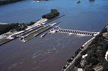
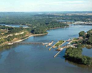
Lock and Dam No. 2 is located along the Upper Mississippi River near Hastings, Minnesota and was originally built in 1907. The eastern dam portion is 722 feet (220 m) wide and has 19 tainter gates. A hydroelectric station that produces about 4.4 megawatts is owned by the city of Hastings, while the 110 by 600 feet (34 m × 183 m) lock is operated by the St. Paul district of the U.S. Army Corps of Engineers' Mississippi Valley Division. There's also a wide earthen dam on the western side of the facility.
Following construction, the original lock walls settled and began to lean out of alignment, so a replacement lock was built. It was finished in 1948. A rehabilitation phase ran from 1987 to 1995. In 2009, Lock and Dam No. 2 became home to the nation's first commercial, federally licensed hydrokinetic power facility, which is a partnership between the City of Hastings and Hydro Green Energy, LLC of Westmont, IL.
External links
- U.S. Army Corps of Engineers, St. Paul District: Lock and Dam No. 2
- U.S. Army Corps of Engineers, St. Paul District: Lock and Dam 2 brochure
- Google Maps: Lock and Dam No. 2
- USGS, Locks 1 through 13
| Locks and dams of the Upper Mississippi River | ||
|---|---|---|
| Upstream: Lock and Dam No. 1 |
Downstream: Lock and Dam No. 3 | |