Lock and Dam No. 7
| Lock and Dam No. 7 | |
|---|---|
|
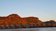
Mississippi River Lock and Dam number 7 | |
 Location of the Lock and Dam No. 7 on the border of Wisconsin and Minnesota | |
| Location |
Campbell, La Crosse County, Wisconsin / Dresbach Township, Winona County, Minnesota, near La Crescent, Minnesota, USA |
| Coordinates | 43°52′01″N 91°18′26″W / 43.86694°N 91.30722°WCoordinates: 43°52′01″N 91°18′26″W / 43.86694°N 91.30722°W |
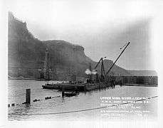
| Construction began | 1933 |
| Opening date | April 1937 |
| Operator(s) | United States Army Corps of Engineers |
| Dam and spillways | |
| Impounds | Upper Mississippi River |
| Length | 940 feet (286.5 m) (movable portion) |
| Reservoir | |
| Creates | Pool 7 |
| Total capacity | 105,000 acre·ft (0.130 km3) |
| Catchment area | 62,340 sq mi (161,500 km2) |
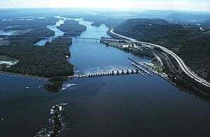
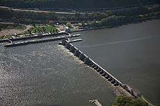
Lock and Dam No. 7 is a lock and dam located near Onalaska, Wisconsin on the Upper Mississippi River. It forms pool 7 and Lake Onalaska.
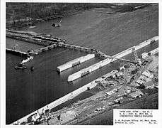
The facility is located on Mississippi River mile 702.5 near La Crescent, Minnesota. It was constructed and placed in operation in April, 1937 and underwent major rehabilitation from 1989 through 2002.
The entire system consists of a concrete structure 940 feet (286.5 m) long with five roller gates and 11 tainter gates, a segment of earth embankment 8,100 feet (2,468.9 m) long from the dam to French Island separated by a concrete spillway 1,000 feet (304.8 m) long, and another embankment 2,400 feet (731.5 m) long from French Island to Onalaska which has a concrete spillway 670 feet (204.2 m) long. The lock is 110 feet (33.5 m) wide by 600 feet (182.9 m) long.[1]
See also
- I-90 Mississippi River Bridge, just downstream.
- Public Works Administration Dams List
Notes
- ↑ "Lock and Dam 7". United States Army Corps of Engineers. Retrieved 2012-08-19.
External links
- USGS Reach 1 pool 7
- U.S. Army Corps of Engineers, St. Paul District: Lock and Dam 7 brochure
- Survey number HAER MN-24 - Upper Mississippi River 9-Foot Channel Project, Lock & Dam No. 7, Dresbach vicinity, Winona County, MN
|
| Locks and dams of the Upper Mississippi River | ||
|---|---|---|
| Upstream: Lock and Dam No. 6 |
Downstream: Lock and Dam No. 8 | |