Long Tom River
| Long Tom River | |
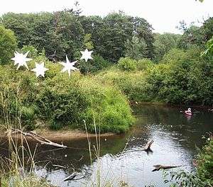 The Long Tom River as it appears while passing through the Oregon Country Fair's land near Veneta | |
| Name origin: Developed gradually in the 19th century in imitation of a native tribal name[1] | |
| Country | United States |
|---|---|
| State | Oregon |
| County | Lane and Benton |
| Source | Central Oregon Coast Range |
| - location | Long Tom Station, Lane County |
| - elevation | 1,131 ft (345 m) [2] |
| - coordinates | 44°13′12″N 123°26′39″W / 44.22000°N 123.44417°W [3] |
| Mouth | Willamette River |
| - location | Norwood Island, Benton County |
| - elevation | 256 ft (78 m) |
| - coordinates | 44°22′48″N 123°14′54″W / 44.38000°N 123.24833°WCoordinates: 44°22′48″N 123°14′54″W / 44.38000°N 123.24833°W [3] |
| Length | 57 mi (92 km) [4] |
| Basin | 410 sq mi (1,062 km2) [5] |
| Discharge | |
| - average | 753 cu ft/s (21 m3/s) [4] |
 Location of the mouth of the Long Tom River in Oregon | |
The Long Tom River is a 57-mile (92 km) tributary of the Willamette River in western Oregon in the United States.[4] It drains an area at the south end of the Willamette Valley between Eugene and Corvallis.[6]
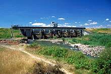
It rises in the Central Oregon Coast Range in western Lane County, approximately 10 mi (16 km) west of Veneta. It flows east through the mountains to Veneta, through the Fern Ridge Reservoir, and then north into the Willamette Valley, roughly parallel to and west of the Willamette River. It joins the Willamette from the southwest approximately 4 mi (6.5 km) west of Halsey. The Fern Ridge Reservoir was created in 1942 when the United States Army Corps of Engineers dammed the river to control flooding.[7]
The watershed includes approximately 410 sq mi (1,100 km2) of land (262,000 acres, 1060 km2) zoned as 45 percent forest, 30 percent agricultural, 8 public, and 17 percent urban or rural residential.[5] The Long Tom waters support more than 140,000 people in the area, including residents in the city of Veneta and the rural farming communities of Alvadore, Cheshire, Crow, Franklin, and Noti, as well as industrial and commercial land on the western edge of Eugene.[8] These lands were inhabited by the Chelamela group of the Kalapuya Indians prior to European settlement.
The Oregon Country Fair is one of many groups and agencies that work with the Long Tom Watershed Council to protect and restore the river.[9]
Name
The river's name developed gradually during the 19th century in imitation of a native tribal group called Lung-tum-ler.[1] The Native American name of this Kalapuyan group is [lámpʰtumpif], literally meaning "spank-his-ass".[10]
Tributaries
Named tributaries from source to mouth are Micheals, Jones, Swamp, Dusky, Hayes, Sweet, Green, and Gold creeks. Then come Noti, Wilson, Indian creeks before the river enters Fern Ridge Reservoir. Hannavan and Inman creeks enter the reservoir as does Coyote Creek. (The topographic map also shows a separate Coyote Creek that leaves the reservoir south of the main Long Tom channel and rejoins it further downstream.) Below the reservoir come Squaw, the second confluence with Coyote Creek, then Lingo Slough, Bear, Amazon, Ferguson, Shafer, and Miller creeks.[6]
See also
- List of longest streams of Oregon
- List of reservoirs and dams in the United States
- List of rivers of Oregon
References
- 1 2 McArthur, Lewis A.; McArthur, Lewis L. (2003). Oregon Geographic Names (Seventh ed.). Portland, Oregon: Oregon Historical Society Press. p. 590. ISBN 0-87595-277-1..
- ↑ Google Earth elevation for GNIS coordinates
- 1 2 "Long Tom River". Geographic Names Information System (GNIS). United States Geological Survey. November 28, 1980. Retrieved July 26, 2009.
- 1 2 3 Palmer, Tim (2014). Field Guide to Oregon Rivers. Corvallis: Oregon State University Press. pp. 173–74. ISBN 978-0-87071-627-0.
- 1 2 "About the watershed". Long Tom Watershed Council. 2003. Retrieved July 26, 2009.
- 1 2 "United States Topographic Map". United States Geological Survey. Retrieved January 26, 2016 – via Acme Mapper.
- ↑ "The Fern Ridge Community Resource Unit". naturalborders.com. Retrieved May 6, 2008.
- ↑ Lane County Profile
- ↑ "Funding and partners: 1998–2003". Long Tom Watershed Council. 2003. Retrieved July 27, 2009.
- ↑ Bright, William (2004). Native American placenames of the United States. University of Oklahoma Press. p. 255. ISBN 978-0-8061-3598-4. Retrieved 14 April 2011.
External links
- Long Tom Watershed Council; includes "virtual tour" and aerial photos