Loro Ciuffenna
| Loro Ciuffenna | ||
|---|---|---|
| Comune | ||
| Comune di Loro Ciuffenna | ||
 | ||
| ||
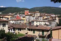
 Loro Ciuffenna Location of Loro Ciuffenna in Italy | ||
| Coordinates: 43°35′N 11°37′E / 43.583°N 11.617°E | ||
| Country | Italy | |
| Region | Tuscany | |
| Province / Metropolitan city | Arezzo (AR) | |
| Frazioni | Anciolina, Casale, Chiassaia, Faeto-Pratovalle Casamona, Gropina, Il Borro, La Villa Malva, Modine-Gorgiti, Poggio di Loro, Querceto, Rocca Ricciarda, San Clemente in Valle, San Giustino Valdarno, Trappola, Trevane | |
| Government | ||
| • Mayor | Piero Lazzerini (Democratic Party) | |
| Area | ||
| • Total | 86.7 km2 (33.5 sq mi) | |
| Elevation | 330 m (1,080 ft) | |
| Population (2010[1]) | ||
| • Total | 5,960 | |
| • Density | 69/km2 (180/sq mi) | |
| Demonym(s) | Loresi | |
| Time zone | CET (UTC+1) | |
| • Summer (DST) | CEST (UTC+2) | |
| Postal code | 52024 | |
| Dialing code | 055 | |
| Website | Official website | |
Loro Ciuffenna is a comune (municipality) in the Province of Arezzo in the Italian region Tuscany, located about 40 kilometres (25 mi) southeast of Florence and about 25 kilometres (16 mi) northwest of Arezzo.
Loro Ciuffenna borders the following municipalities: Castel Focognano, Castel San Niccolò, Castelfranco di Sopra, Castiglion Fibocchi, Ortignano Raggiolo, Talla, Terranuova Bracciolini.
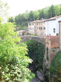
Bridge in the village of Loro Ciuffenna
Twin towns
References
External links
| Wikimedia Commons has media related to Loro Ciuffenna. |
This article is issued from Wikipedia - version of the 1/31/2015. The text is available under the Creative Commons Attribution/Share Alike but additional terms may apply for the media files.