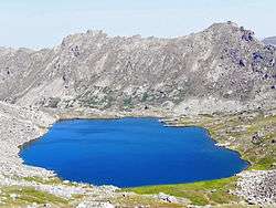
Lost Man Lake
| Lost Man Lake | |
|---|---|
 Lost Man Lake | |
| Location | Pitkin County, Colorado, United States |
| Coordinates | 39°09′13″N 106°34′09″W / 39.153537°N 106.569056°WCoordinates: 39°09′13″N 106°34′09″W / 39.153537°N 106.569056°W |
| Type | Glacial |
| Primary outflows | Lost Man Creek |
| Basin countries | United States |
| Max. length | 0.23 mi (0.37 km) |
| Max. width | 0.13 mi (0.21 km) |
| Surface elevation | 12,457 ft (3,797 m) |
Lost Man Lake is an alpine lake in Pitkin County, Colorado, United States, located high in the Sawatch Range in the Hunter-Fryingpan Wilderness of White River National Forest. The lake is accessible via the Lost Man Loop Trail from State Highway 82 west of Independence Pass. The lake is over a pass and north of Independence Lake and northeast of Geissler Mountain.[1][2] It is a moderate half day hike. Depending on snow pack and weather, lake may still be frozen in July. Great senic views.
References
- ↑ "Lost Man Lake". Geographic Names Information System. United States Geological Survey. Retrieved August 21, 2012.
- ↑ Aspen/Independence Pass 127 (Map) (2005 ed.). Trails Illustrated. National Geographic Society. 1984.
This article is issued from Wikipedia - version of the 6/12/2015. The text is available under the Creative Commons Attribution/Share Alike but additional terms may apply for the media files.