Lough Arrow
| Lough Arrow Loch Arbhach | |
|---|---|
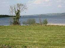
 Toward the Bricklieve Mountains | |
 Location in Ireland | |
| Location | County Sligo, County Roscommon |
| Coordinates | 54°3′12″N 8°19′15″W / 54.05333°N 8.32083°WCoordinates: 54°3′12″N 8°19′15″W / 54.05333°N 8.32083°W |
| Lake type | mesotrophic |
| Primary inflows | Mainly spring-fed, also some streams |
| Primary outflows | Unshin River |
| Catchment area | 65.76 km2 (25 sq mi) |
| Basin countries | Ireland |
| Max. length | 6 km (3.7 mi) |
| Max. width | 2 km (1.2 mi) |
| Surface area | 12.47 km2 (4.81 sq mi) |
| Average depth | 9 m (30 ft) |
| Max. depth | 33 m (108 ft) |
| Surface elevation | 53 m (174 ft) |
| Islands | 4 |
| References | [1][2][3][4][5] |
Lough Arrow (Irish: Loch Arbhach)[6] is a freshwater lake in the northwest of Ireland. This large, scenic lake covers an area of 12.47 square kilometres (4.8 sq mi) and lies mostly in County Sligo with a smaller part in County Roscommon. It is a popular trout fishing lake.
Geography
Lough Arrow lies mostly in south County Sligo about 24 kilometres (15 mi) southeast of Sligo and 6 km (4 mi) northwest of Boyle. The Bricklieve Mountains rise west of the lake.
Lough Arrow is about 6 km (3.7 mi) long from north to south and 2 km (1.2 mi) wide.[4] The lake has four islands: Annaghgowla, Inishmore, Inishbeg and Muck.[5]
Hydrology
Lough Arrow is a mesotrophic lake. It is fed mainly by springs but also by a number of streams entering on the lake's western and southern sides.[1] The lake drains north into the Unshin River.[4][5] The mean lake depth is 9 m (30 ft) with a maximum depth of 33 m (108 ft).[4]
Natural history
Fish present in Lough Arrow include brown trout, perch, roach, three-spined stickleback, pike, rudd, bream and the critically endangered European eel.[4] A number of duck species winter at the lake including mallard, wigeon, teal, red-breasted merganser, tufted duck, pochard and goldeneye. Other bird species found at the lake include great crested grebe, little grebe, cormorant and mute swan.[3]
Lough Arrow has been designated a Special Area of Conservation as a hard water lake habitat.[1]
History
A number of important historical sites are located in the area around Lough Arrow. Carrowkeel Megalithic Cemetery is located in the Bricklieve Mountains above the lake's western side. It is a site of megalithic cairns, also including the largest megalithic village in Ireland.[7] Moytura, located on the eastern side of the lake, features standing stones and is also the site of the mythological Second Battle of Moytura.[8]
See also
References
- 1 2 3 "Lough Arrow SAC" (PDF). National Parks and Wildlife Service (Ireland). Retrieved 21 May 2015.
- ↑ "A Reference Based Typology and Ecological Assessment System for Irish Lakes" (PDF). Environmental Protection Agency (Ireland). 2006. p. 10. Retrieved 17 May 2015.
- 1 2 "Lough Arrow". BirdWatch Ireland. Retrieved 17 May 2015.
- 1 2 3 4 5 "Water Framework Directive Fish Stock Survey of Lough Arrow" (PDF). Inland Fisheries Ireland. July 2012. Retrieved 17 May 2015.
- 1 2 3 Google (17 May 2015). "Lough Arrow" (Map). Google Maps. Google. Retrieved 17 May 2015.
- ↑ "Loch Arbhach/Lough Arrow - logainm.ie". Gazetteer of Ireland. Government of Ireland - Department of Arts, Heritage and the Gaeltacht. Retrieved 17 May 2015.
- ↑ "The cairns at Carrowkeel". Carrowkeel.com. Retrieved 17 May 2015.
- ↑ "The Second Battle of Moytura". Carrowkeel.com. Retrieved 17 May 2015.
| Wikimedia Commons has media related to Lough Arrow. |