Lough Talt
| Lough Talt | |
|---|---|
| Location | County Sligo |
| Coordinates | 54°5′0″N 8°55′30″W / 54.08333°N 8.92500°WCoordinates: 54°5′0″N 8°55′30″W / 54.08333°N 8.92500°W |
| Surface area | 194 acres (79 ha) |
| Max. depth | 67 ft (20 m) |
| Surface elevation | 500 ft (150 m) |
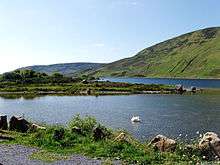
Lough Talt (Irish: Loch Tailt) is situated in south Sligo between the villages of Tubbercurry, Aclare and Bunnyconnellan, in the West of Ireland. It is the largest of the lakes in the Lough Hoe Bog area. It is a glacier lake and lies at approximately 500 ft above sea level and measures 67 ft at its deepest point. Its area is nearly 194 acres.[1]
The lake is a noted site of picture perfect sunsets on calm evenings, as the sun sinks over "The Gap".
Fishing
The Lake is a good source of brown trout averaging 250g. Arctic char are also reported to be still present in the deeper waters of the lake. The trout are free rising and their weight averages about a half pound.[2] Lough Talt has a notable population of fresh water crayfish, a species that is listed on Annex II of the E.U. Habitats Directive.
Walking trail
The Lough Talt mountain pass is popular among walkers. It has a 6.5 km circuit winding around its shore. It also serves as the starting point for The Sligo Way, a 74 km long linear trail that ends in the village of Dromahair in Leitrim County.[3]
Water Supply
Lough Talt is the source of domestic treated water for a large percentage of the population in South Sligo.
References
- ↑ South Sligo Walking Festival. "Physical Features of Lough Talt and Lough Easkey". Retrieved 1 May 2012.
- ↑ Wgsten (August 12, 2009). "Lough Talt, County Sligo".
- ↑ Ciaran McHugh Photography. "Lough Talt". Retrieved 1 May 2012.
| Wikimedia Commons has media related to Lough Talt. |