Loughborough Gap
The Loughborough Gap is a 500-metre-long (0.3 mi) missing section of the Great Central Railway to the north-eastern of Loughborough, England. The gap was created by the removal of embankments and bridges during the 1980s and the restoration project has been branded Bridge to the Future and Bridging the Gap. From south-to-north the route crosses the Grand Union Canal, Railway Terrace road, four-track Midland Main Line at Loughborough railway station and the A60 road. The Hermitage Brook watercourse runs parallel.
During the 2010s work began to restore the link in order to join the northern and southern sections of heritages railway back together giving a total Great Central Railway (heritage railway) line length of 18 miles (29 km).[1] As of 2016, planning permission was granted to the first major component: a replacement 30-metre single-span bridge over the Midland Main Line. An additional station called Loughborough High Level will be built to connect with Loughborough (Midland) station on the Midland Main Line.
As of May 2016, the bridge was intended to be owned by Charnwood Borough Council and then leased back to the Great Central Railway for one hundred years in exchange for maintenance costs.[2] It is expected to be completed in 2019.[1][2]
History
As a relatively late-developed railway in the United Kingdom, the GCR was resultantly forced to take some expensive civil engineering choices to complete their route. Just north of Loughborough Central, the railway had to cross the existing Leicester section of the Grand Union Canal, before then crossing the existing Midland Main Line formation as well as avoiding the Hermitage Brook, before moving northwards to Nottingham.[3]
Choosing to approach the location on a raised embankment, the railway engineers used a steel-decked span bridge to cross the canal, before using a double-deck, double-width steel-decked span bridge to cross the Midland Railway.[3]
After the decision was made to shut the GCR as part of the Beeching Axe, in the late 1960s contractors were appointed to remove the railway tracks and major parts of the civil engineering infrastructure. This included the section north of Loughborough Central to north of the Midland Main Line. Contractors initially removed the railway tracks, before also removing the bridges and supporting buttresses over the Midland Main Line, and then the embankment to its south. Unfortunately, the following year the Hermitage Brook flooded, resulting in additional contractors being engaged to reimplement part of the railways former embankment.[3]
After the formation of the Great Central as a heritage railway, bridging the resultant "gap" always became a significant challenge to realise the full operational vision. In the mean time, Morley Street industrial estate had been developed on part of the embankments former formation, whilst Loughborough Borough Council had developed, filled with household waste and then covered a landfill to the south. The GCR itself, having started it re-implementation of the GCR line from Loughborough Central to the south, had developed its main locomotive shed on the old alignment to the north of the station.[3]
Current features
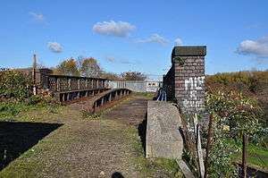
The Gap is 500 metres (550 yd) long, and approximately 30 metres (33 yd) wide for most of its length, running due north–south approximately 1 kilometre (0.6 mi) north from Loughborough Central. It is bounded: to the west by the northeasternmost part of Loughborough, including the Loughborough Midland station and Morley Street industrial estate; to the east by the covered former household refuse site; and to the north and south by GCR's northern and southern sections respectively.
Current plans for bridging the gap, using a single-track line, include:
- Removing the Loughborough north shed, although this will be a long term project, the approach from the canal bridge to loughborough North signal box will be a single track running alongside the existing shed. This has already been 3D modelled to prove feasability.
- The Loughborough Top Shed project would then rebuild the recovered remnants of the former LNWR Workington, Cumbria steam shed on an old landfill site, just to the north-east of the current shed
- Using two donated 17 m (19 yd) spans of the former Great Western Main Line to the west of Reading, removed in April 2011 by Network Rail when revamping the station as part of an £825million project. These were originally planned to bridge the gap over the Midland Main Line,[4] but were later instead planned to be deployed elsewhere in the project
- To renovate the residual bridge over the canal
Once complete, the project will create a combined 18-mile-long (29 km) heritage railway.
Implementation
After the UK Government's announcement in 2012 that the Midland Main Line would be electrified by 2018, the project timescales to be completed or not were implemented. In 2013, the GCR engaged Network Rail to act as project engineers, project manager and main contractor to complete the project. In June 2013, the GCR and Network Rail signed an agreement to allow bridging of the Midland Main Line, including the underlying operations, maintenance and legal liability agreements for such.[5]
Preliminary works began January 2014 with boreholes being drilled in preparation for the bridge over the Midland Main Line at Loughborough.[6][7]
In July 2014, the GCR received a one million pound grant from the UK Government’s "Local Growth Deal", via an allocation to the Leicester and Leicestershire Local Enterprise Partnership; the grant will support the GCR’s "Bridging the Gap" project.[8]
Planning application
On 15 April 2014 a planning application was submitted by Great Central Railway PLC with Network Rail acting as agents for "Installation of rail bridge over midland mainline"; which was granted on 27 June 2014.[9] The bridge was envisioned as being single-track and made of two spans and a central supporting pillar in the middle. On 10 February 2015 a non-material minor amendment was applied for in order to allow construction using a single-span bridge design "to remove [the] central pillar"; which was granted by Charnwood Borough Council on 26 March 2015.[10] A two-span design had originally been proposed in order to enable reuse of bridge components removed during the rebuilding of Reading station.
Contracts and legals
Although the GCR owns the track from Loughborough to Leicester North, the underlying land is owned by Charnwood Borough Council, on a 99 lease signed in 1976. Bridges over or under Network Rail infrastructure must be owned by organisations which can provide suitable legal liability to any incidents which may occur as a result of operations, which means to meet this requirement the owning organisation needs to have a minimum Net present value of over £250M. As the GCR can not clearly meet this criteria, after contract negotiations, it was agreed that Charnwood Borough Council will retain ownership of the land up to the southern abutment of the new bridge, whilst Network Rail will become the owner of the new bridge. The GCR will resultantly negotiate an operational lease agreement with Network Rail, which will define operational requirements which the GCR must comply with over the bridge.[11]
Construction starts
On 12 February 2016, work began to install the new bridge across the Midland main line.[1]
References
- 1 2 3 "Mind the Gap: Great Central Railway to be joined after 40 years". BBC News. BBC. 12 February 2016. Retrieved 14 February 2016.
- 1 2 Jarram, Matt (19 May 2016). "Ownership plan for GCR bridge". Loughborough Echo. Retrieved 25 May 2016.
Charnwood Borough Council has agreed to take ownership of the Great Central Railway bridge … set to be opened in 2019. … will then lease the bridge back to GCR over a 100-year contract. … to maintain the bridge over its 120-year life span will cost around £305,000.
- 1 2 3 4 "The Loughborough 'Gap'". Great Central Today. Retrieved 11 January 2014.
- ↑ "Old Reading station bridge joins Great Central Railway". BBC News. 11 April 2011. Retrieved 11 January 2014.
- ↑ "Great Central Railway bridges Loughborough gap". RAIL (magazine). 10 June 2013. Retrieved 11 January 2014.
- ↑ "Great Central Railway bridge preparation work begins". BBC. 11 January 2014. Retrieved 11 January 2014.
- ↑ Stanway, Phil (January 2014). "New Midland Mainline Bridge Moves a Step Closer - Test Bore Holes Drilled.". Great Central Railway North website. Retrieved 10 June 2015.
Contractors appointed by Network Rail moved onto site for three days between January 7th and 9th to carry out investigation works. Boreholes are being drilled at each end of the site to establish the ground conditions for the abutments which will support the bridge decks.
- ↑ "One Million Pound Government Grant For Reunification". GCR. 7 July 2014. Retrieved July 11, 2014.
- ↑ Network Rail (27 June 2014). "P/14/0625/2 Land southeast of Loughborough Railway Station Nottingham Road Loughborough Leicestershire". Charnwood Borough Council. Retrieved 11 May 2015.
"Application Number: P/14/0625/2" (Planning Document Search Results). Retrieved 11 May 2015. - ↑ Network Rail (26 March 2015). "P/15/0202/2 Land southeast of Loughborough Railway Station Nottingham Road Loughborough Leicestershire". Charnwood Borough Council. Retrieved 11 May 2015.
"Application Number: P/15/0202/2" (Planning Document Search Results). Retrieved 11 May 2015. - ↑ http://www.gcrailway.co.uk/unify/
External links
| Wikimedia Commons has media related to Loughborough Gap. |
- Project website (archived version - original now offline)
- Great Central Railway.
- Nottingham Transport Heritage Centre.
Coordinates: 52°46′42″N 1°11′37″W / 52.77844°N 1.19349°W