Lower Madawaska River Provincial Park
| Lower Madawaska River Provincial Park | |
|---|---|
|
IUCN category II (national park) | |
|
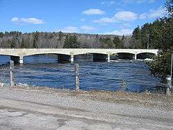
Highway 41 bridge at Griffith. This bridge is the downstream limit of the Madawaska River Park. | |
 | |
| Location | Madawaska River |
| Nearest city | Renfrew, Ontario |
| Coordinates | 45°14′06″N 77°21′17″W / 45.23500°N 77.35472°WCoordinates: 45°14′06″N 77°21′17″W / 45.23500°N 77.35472°W |
| Area | 12 km2 (4.6 sq mi) |
| Governing body | Ontario Parks |
Lower Madawaska River Provincial Park is a waterway-class provincial park on the Madawaska River in Renfrew County, Ontario, Canada. The park includes the shores on both sides of the Madawaska River from Latchford Bridge to Griffith.
A non-operating park, it offers neither facilities nor services. Its most popular use is for whitewater kayaking and canoeing.
See also
External links
This article is issued from Wikipedia - version of the 11/19/2016. The text is available under the Creative Commons Attribution/Share Alike but additional terms may apply for the media files.