Lower Morava Valley
| Lower Morava Valley | |
|---|---|
 | |
| Highest point | |
| Peak | Žerotín (Zierotin) |
| Elevation | 322 m (1,056 ft) |
| Dimensions | |
| Length | 83 km (52 mi) |
| Area | 1,452 km2 (561 sq mi) |
| Geography | |
| Location | Dolnomoravský úval CZ IV1 A-2.png |
| Country | Moravia |
| State | Czech Republic |
| Range coordinates | 48°34′N 17°49′E / 48.56°N 17.81°ECoordinates: 48°34′N 17°49′E / 48.56°N 17.81°E |
| Parent range | Carpathians |
| Geology | |
| Orogeny | Alpide belt |
| Age of rock | Neogene |
| Type of rock | Gravel and Sand |
The Lower Morava Valley Czech: Dolnomoravský úval /Jihomoravská pánev also, German: Nieder March Talsenke, Slovak: Dolnomoravský úval) is a geomorphological formation (special type of Valley) in the Moravia (Czech Republic). It is formed by the depression in the western Carpathian Mountains (Ždánice Forest, Kyjov Hills and Mikulov Hills) in the west and Bílé Karpaty and Chvojnice hills in the east. The drainage to the River Morava of the Danube basin runs finally to the Black Sea.
Including low watershed Dyje-Morava in Lanžhot.[2]
The Lower Morava Valley is a nordest part of Vienna basin (Carpathians) and the corridor to Napajedla Gate, Upper Morava Valley, Moravian Gate and later in final goal North European Plain (Poland- Lower Silesia - Galicia) since ancient times. Here ran one arm of the most important trade routes from southern Europe to the Baltic Sea (e.g. the Amber Road - eastern branch) and also routes from Moravia to Upper Silesia and Lesser Poland. The Emperor Ferdinand Northern Railway (one part) built in 1840-41 from Břeclav (Vienna) to Přerov also traversed the Lower Morava Valley.
The Morava and Dyje rivers, Myjava (river), Chvojnice, Trkmanka, Kyjovka as well among others, finishing here in theirs floodplains,[3] and the towns include Břeclav, Hodonín, Uherské Hradiště, Valtice, Poštorná and Mikulčice.
Soil horizon - mainly sand, fluvisol and loess, partly chernozem .
See also
- Vyškov Gate
- Subcarpathia
- Outer Carpathian depressions
- South-Moravian Carpathians
- Upper Morava Valley
- Dyje–Svratka Valley
 Lower Morava Valley (olive green) down right
 Morava Dyje confluence - riparian forest
 Lower Morava Valley landscape Hodonín surrounding
%2C_alt%C3%A1n.jpg) View from Náklo Hill (265 m) to the Lower Morava Valley landscape
View from Náklo Hill (265 m) to the Lower Morava Valley landscape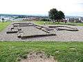 View of the Lower Morava Valley from the Sady archaeological site
References
- ↑ Riparian forest Morava-Dyje confluence
- ↑ Functioning of South Moravian Floodplain Forests
- ↑ FIELD TRIP to the floodplain forests of the Lower Morava Biosphere Reserve
Further reading
- (1993) Geografický místopisný slovník, Academia, Praha. ISBN 80-200-0445-9
- (1997) Plašienka, D., Grecula, P., Putiš, M., Kováč, M. a Hovorka, D.,: Evolution and structure of the Western Carpathians: an overview. Mineralia Slovaca - Monograph, Košice, s. 1 – 24.
| Wikimedia Commons has media related to Dolnomoravský úval. |