Lowry Hill Tunnel
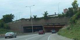
 The entrance of Lowry Hill Tunnel from the north/west, below Hennepin and Lyndale Avenues | |
| Overview | |
|---|---|
| Location | Minneapolis, Minnesota |
| Route |
|
| Operation | |
| Opened | 1971 |
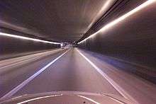
Lowry Hill Tunnel is a tunnel accommodating the Interstate 94 (I-94) freeway near downtown Minneapolis, Minnesota that was completed in late 1971. It is placed at a near-right-angle turn in the highway, forcing the three lanes of traffic in each direction to slow down. The advised speed is 35 miles per hour (56 km/h).
Although constructed as a tunnel through rock, the surface a few yards above is covered with roadways. The tunnel functions as if it were the underpass under a 0.25-mile-wide (400 m) bridge which carries Hennepin Avenue, Lyndale Avenue, and various ramps over I-94.
It is a bottleneck due to its dog-leg turn, and various proposals have been made for dealing with it. In May 2005, one city engineer proposed restriping it to four lanes in each direction. This would not help the slowdown, but would theoretically allow more cars through it at a given time. The tunnel is also a leading contender for a new high-occupancy toll lane using the MnPASS electronic toll collection system.
Some believe that Interstate 335, a proposed but never-built freeway north of downtown between I-94 and Interstate 35W, would have alleviated the traffic problems in the tunnel. However, others have noted that the highway would not have benefited many drivers, particularly since the nearby interchange between I-35W and I-94 is missing certain links. There is no connection to carry southbound I-35W traffic to eastbound I-94, or westbound I-94 traffic to northbound I-35W, both of which would have been important flows if I-335 were to be successful.
External links
| Wikimedia Commons has media related to Lowry Hill Tunnel. |
Coordinates: 44°57′57″N 93°17′18″W / 44.96583°N 93.288217°W