Lulua Mosque
| Lulua Mosque Masjid al-Lu'lu'a | |
|---|---|
|
Lulua Mosque renovated by Dawoodi Bohras, Cairo | |
| Basic information | |
| Affiliation | Islam |
| District | Cairo Governorate |
| Region | Egypt |
| Status | Active |
| Architectural description | |
| Architect(s) | Al-Hakim bi-Amr Allah |
| Architectural type | Mosque |
| Architectural style | Fatimid style of architecture |
| Completed | Original in 1015–16 AD, new 1998 |
| Specifications | |
| Dome(s) | 1 |
| Minaret(s) | 1 |
| Materials | limestone, rubble and bricks |
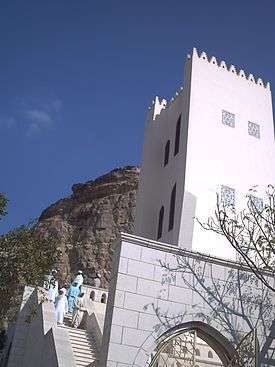
The Lulua Mosque (Arabic: مسجد لؤلؤة) (meaning:the Pearl) is a mosque in Cairo, Egypt, that was built in 1015–16 AD. The mosque is also known by many other names like al-Lu'lu'a Mosque, Majid aasl-Luʼluʼah, Mosque of al-Lu'lu'a, Mosque of al-Lulua, Luluah Mosque, Qabr Lu'lu'a Bint al-Muqauqis, Mosque of al Lulua.[1] It was constructed during the reign of the third[2] Fatimid caliph, al-Hakim, in the Fatimid architectural style.[3] The mosque partially collapsed in 1919, but was later refurbished in 1998 by the Dawoodi Bohras, who trace their religious lineage to the Fatimid Caliphate. It is located in the southern cemetery in the Moqattam hills.[1][4]
Geography
The mosque is located near the southern cemetery of the Muqattam Hills,[1] a low range of hills to the east of Cairo. It has an average height of 180 metres (590 ft) with the highest peak at 213 metres (699 ft) above sea level. It is divided into three sections. The highest segment is a low mountain landform called Moqattam Mountain. It was an important ancient Egyptian quarry site for limestone, used in construction of mosques and churches. The Lulua Mosque was also built with this limestone. The mosque is close to this hill range. The mosque is about 1 kilometre (0.62 mi) from the Sharia Salah Salim, towards the southeast.[4][5]
History

Fatimid Caliph al-Hakim (996–1021), the third caliph in Egypt of the Ismaili Shia Dynasty, also credited with building Cairo, built this mosque among many small mosques that were built on the Muqattam Hill. He was considered an inscrutable and misunderstood ruler.[6][7] [8] He was reportedly lost in the hill ranges while wandering in a strange manner in the night; his cloak was found with a dagger stashed in it. Etymologically the name al-Lu'lu'a means "the pearl" as the mosque's exterior appearance was ornate and lustrous.[4]
Features
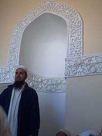
The Fatimid mosque was built on a promontory of limestone, precariously perched as a detached component of the hill range. The exposed limestone formed the foundation for the mosque structure.[4] The mosque was built in the unique Fatimid architectural style. It is one of the early mosques built in Egypt, where the typical Fatimid architectural style, which involved portals with slight protrusions, mihrabs and qibla walls (covered by ornamentation) topped by domes indicative of the place of worship, columned porches with triple arches or keel shaped arches, frontage with inscriptions could be seen.[3] The Lulua Mosque consisted originally of a three-storey tower-like structure built over a rectangular plan. The ground floor was partially excavated from the hill. It was barrel vaulted having triple arched entrance, simple qibla (mihrab) on the back wall and was constructed of limestone with rubble. The upper stories were constructed with bricks and interior wall plastered. One of these upper stories also had triple arched entrance; the arches were built with brick and stone. The middle floor, barrel vaulted, had an ornamented qibla (Mihrab) at back and one rectangular window. The top floor had two compartments, each having one window. The vaults at the upper floors were built with brick.[1][4][8]
Some of the architectural features common to all mosques built by Al-Hakim, including Lulua Mosque, are adoption of projected portals and domes over mihrabs for ceremonial purposes. Keel-shaped arches in porticoes and arcades were also prominent features. The profusion of fine stucco decorations were seen in large numbers, particularly on mihrabs and qibla walls. Iconographic inscriptions were abundant on the façade.[7]
The first reported refurbishing of the mosque was in the 16th century.[7] After its façade and vaults collapsed in 1919, the mosque was refurbished by India's Dawoodi Bohra community in the late 1990s.[1][9] The Bohras trace their religious lineage to the Ismāʿīlī Islam practiced by the Fatimid Caliphate.
A manzara[10]) was also built near the mosque, which was used as guest house for foreign visitors and subsequently converted into a hostel for merchants visiting from other countries.[11]
References
- 1 2 3 4 5 "Al-Lu'lu'a Mosque". Retrieved 3 December 2010.
- ↑ Note: Sources conflict on the period of dating the mosque - either during the reign of the third Fatimid caliph (per MIT) or of the sixth caliph, in another ("Hakem be-Amr Allah" entry, Encyclopædia Iranica Vol. 11, pp. 572-573, ed. Ehsan Yarshater. Encyclopædia Iranica Foundation & Eisenbrauns, Inc., New York, 2003). MIT is cited here, pending agreement of authoritative sources.
- 1 2 "5 – Fatimid Mosques in Cairo". Massachusetts Institute of Technology. Retrieved 8 March 2013.
- 1 2 3 4 5 Williams, Caroline; Williams, Caroline H. (30 December 2008). Islamic Monumentss in Cairo: The Practical Guide. American Univ in Cairo Press. pp. 279–. ISBN 978-977-416-205-3. Retrieved 7 February 2013.
- ↑ Särkkä, P.; Eloranta, Pekka (2001). Rock Mechanics – A Challenge for Society: Proceedings of the Isrm Regional Symposium Eurock 2001, Espoo, Finland, 4 – 7 June 2001. Taylor & Francis. pp. 402–. ISBN 978-90-265-1821-8. Retrieved 1 March 2013.
- ↑ Bloom, Jonathan M.; Institute of Ismaili Studies (2007). Arts of the City Victorious: Islamic art and architecture in Fatimid North Africa and Egypt. Yale University Press. ISBN 978-0-300-13542-8. Retrieved 1 March 2013.
- 1 2 3 "5 – Fatimid Mosques in Cairo". The Mosque of al-Lu'lu'a:(1015-16). Mit.edu. Retrieved 1 March 2013.
- 1 2 "Al-Lu'lu'a Mosque". Unusualegypt.com. Retrieved 1 March 2013.
- ↑ Williams, Williams (2008), p. 129
- ↑ Manzara (n): Arabic: a place with commanding views. Per Aquilina, Joseph (1987-1990) Maltese-English Dictionary, I-II, p. 776. Midsea Books Ltd, Malta.
- ↑ Behrens-Abouseif, Doris (1985). Azbakiyya and Its Environs from Azbak to Ismā Īl, 1476–1879. Institut français d'archéologie orientale. Retrieved 7 February 2013.

Coordinates: 30°01′11″N 31°16′05″E / 30.01986°N 31.268187°E