Luro, Hordaland
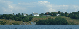 View of the island and the local church | |
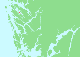 Location in Hordaland county | |
| Geography | |
|---|---|
| Location | Hordaland, Norway |
| Coordinates | 60°41′49″N 5°05′54″E / 60.6970°N 5.0984°ECoordinates: 60°41′49″N 5°05′54″E / 60.6970°N 5.0984°E |
| Area | 2.5 km2 (0.97 sq mi) |
| Length | 4 km (2.5 mi) |
| Width | 680 m (2,230 ft) |
| Highest elevation | 52 m (171 ft) |
| Administration | |
| County | Hordaland |
| Municipality | Lindås |
Luro or Lygra is an island in Lindås municipality in Hordaland county, Norway. The 2.5-square-kilometre (0.97 sq mi) island sits in the Lurefjorden which cuts into the Lindås peninsula. There is one road on the island that continues over a short bridge onto the mainland. The bridge was built in 1972. The island has been the site of Lygra Church since the middle ages. There are Viking age tombstones that are still standing on the island. The Heathland Centre is located on Lygra. It is an information centre about the cultural landscape in this coastal area. There are nearly 200 hectares (490 acres) of heathland that are managed in traditional ways by local farmers.[1][2]
See also
References
- ↑ "Heathland centre, Lygra". CoastsAlive.eu. Retrieved 2014-03-25.
- ↑ "Lyngheisenteret" (in Norwegian). Museumssenteret i Hordaland. Retrieved 2014-03-25.
This article is issued from Wikipedia - version of the 11/17/2016. The text is available under the Creative Commons Attribution/Share Alike but additional terms may apply for the media files.