Lyme Brook
| Lyme Brook | |
 View across the brook near Newcastle-under-Lyme | |
| Country | England |
|---|---|
| Counties | Staffordshire |
| Mouth | |
| - location | Hanford, Staffordshire |
| - coordinates | 52°58′44″N 2°12′11″W / 52.979°N 2.203°WCoordinates: 52°58′44″N 2°12′11″W / 52.979°N 2.203°W |
| Length | 4.1 km (3 mi) [1] |
| Basin | 31 km2 (12 sq mi) [2] |
 Lyme brook within Staffordshire | |
| Progression : Lyme Brook—Trent—Humber | |
Lyme Brook is a tributary stream of the River Trent, which flows through Newcastle-under-Lyme, and the outlying areas of Stoke-on-Trent in Staffordshire, England.[3][4]
Course
Prior to the 20th century the upper course of the brook could be traced through the area to the north of Newcastle, but subsequent development and culverting means that only parts are now visible.[5]
To the south of Newcastle town centre, the brook joins together with a number of its tributaries including the Silverdale and the Ashfield brooks. This area between Rotterdam and Pool Dam was important historically, as the water from the brooks was dammed to form a protective pool around the ‘new’ Motte-and-bailey castle in the 12th century, after which the town is named.[5]
From Pool Dam, the brook has been designated as main river, which flows south-east in a narrow valley, between Clayton and Trent Vale. The brook then passes under the A500 dual carriage-way, joining the Trent near Hanford.[3]
The catchment or drainage basin lies between that of the Fowlea Brook to the north and east, and that of the Park brook to the south, and has an area of 31 square kilometres (12 sq mi).[2]
Floods
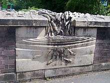
The brook is capable of causing flooding, and was the subject of a flood alleviation scheme in the 1990s by the National Rivers Authority. The completed scheme was commemorated by a sculpture on the Brook Lane bridge, known as The Return. The 1995 carved stone sculpture by local artist Ian Randall, shows a cascade of fish returning to the brook.[6]
A flood warning service is provided for the brook, and encompasses areas at risk such as, Brook Lane, Hatrell Street and the Lyme Valley sports fields.[7]
Pollution and ecology
Along with other watercourses draining the Potteries such as Ford Green Brook and the Fowlea Brook, Lyme brook suffered from pollution as the area developed following the Industrial Revolution with sewage effluent from Newcastle being discharged into the brook. The building of sewerage treatment works removed the gross pollution, but problems still persisted.[8]
Lyme brook is still classed as having bad ecological quality under the Water Framework Directive, the lowest rating for any stream in North Staffordshire. This is the lowest of the bands in the five part framework scale, which ranges from high, good, and moderate, through to poor and finally bad. Problems include poor water quality and low levels of aquatic ecology.[4][9][10]
References
- ↑ Length from Pool Dam to the confluence with the Trent. Jenkins 1963
- 1 2 "WFD Surface Water Classification Status and Objectives 2012 csv files". Environment-agency.gov.uk. Retrieved 20 April 2014.
- 1 2 Ordnance Survey (2006). 118 Stoke-on-Trent & Macclesfield. OS Landranger Map Series. Ordnance Survey. ISBN 9780319229064.
- 1 2 "Water Framework Directive - River Basin Management Plans". What's in your Backyard. Environment Agency. Retrieved 11 May 2014.
- 1 2 J. G. Jenkins (editor) (1963). "Newcastle-under-Lyme: Introduction". A History of the County of Stafford: Volume 8. Institute of Historical Research. Retrieved 20 June 2014.
- ↑ "The Return". National Recording Project. public monuments and sculpture association. Retrieved 20 June 2014.
- ↑ "Lyme Brook at Newcastle under Lyme and Trent Vale". Flood Warning Area Detail. Environment Agency. Retrieved 11 May 2014.
- ↑ J. G. Jenkins (editor) (1963). "Stoke-upon-Trent: Local government, economic history and social life". A History of the County of Stafford: Volume 8. Institute of Historical Research. Retrieved 20 June 2014.
- ↑ "Bad rating for polluted brook". The Sentinel. 2013. Retrieved 20 May 2014.
- ↑ "Rivers and Brooks of Stoke on Trent". Canals and Waterways. thepotteries.org. Retrieved 14 March 2014.