M-113 (Michigan highway)
| ||||
|---|---|---|---|---|
|
M-113 highlighted in red | ||||
| Route information | ||||
| Maintained by MDOT | ||||
| Length: | 16.573 mi[1] (26.672 km) | |||
| Existed: | November 1927[2][3] – present | |||
| Major junctions | ||||
| West end: |
| |||
|
| ||||
| East end: |
| |||
| Location | ||||
| Counties: | Grand Traverse | |||
| Highway system | ||||
| ||||

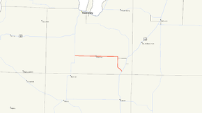
M-113 is a state trunkline highway in the US state of Michigan that runs in Grand Traverse County from M-37 near Hannah to US Highway 131 (US 131) in Walton Junction. The trunkline runs through farm fields and woodlands in a rural area of the county. It connects the highways at its termini with the village of Kingsley. First designated in November 1927, the highway was extended in 1940 by adding the southernmost section near Walton Junction which was originally part of US 131.
Route description
M-113 starts west of Hannah at an intersection with M-37 south of Traverse City. The highway runs eastward through farm fields. In the community of Hannah, the highway passes the church and the cemetery before exiting. On the other side of the town, M-113 continues through more fields to Kingsley. The trunkline follows Main Street through the business district in the village. On the east side of town, M-113 runs through fields mixed with scattered groves of trees. The landscape transitions over to woodland just before a 90-degree turn south near Fife Lake. About one mile (1.6 km) south of the turn, M-113 intersects M-186 at the latter's western terminus. M-113 continues due south past Camp Pugsley Correctional Facility and turns southeasterly.[4][5] The highway crosses a line of the Great Lakes Central Railroad,[6] and then it terminates at US 131 north of the Manistee River and the Grand Traverse–Wexford county line.[4][5]
M-113 is maintained by the Michigan Department of Transportation (MDOT) like other state highways in Michigan. As a part of these maintenance responsibilities, the department tracks the volume of traffic that uses the roadways under its jurisdiction. These volumes are expressed using a metric called annual average daily traffic, which is a statistical calculation of the average daily number of vehicles on a segment of roadway. MDOT's surveys in 2009 showed that the highest traffic levels along M-113 were the 7,519 vehicles daily in the village of Kingsley; the lowest count was 4,161 vehicles per day south of the M-186 intersection.[7] No section of M-113 has been listed on the National Highway System,[8] a network of roads important to the country's economy, defense, and mobility.[9]
History
M-113 was first designated in November 1927 from M-42 (now M-37) west of Kingsley to a three-way junction with US 131 and M-131 near Fife Lake; at this time, US 131 ended west of Fife Lake and M-131 continued east to Fife Lake and north to Petoskey.[2][3] M-42 was replaced by M-37 in 1940, and US 131 was relocated around the same time north from Walton Junction along a new alignment to Fife Lake. From Fife Lake northward, US 131 replaced M-131. The portion of M-131 running west of Fife Lake became M-186 and the remaining piece of US 131 between M-113 and Walton Junction was added to M-113.[10][11] The routing has remained unchanged since.[4]
Major intersections
The entire highway is in Grand Traverse County.
| Location | mi[1] | km | Destinations | Notes | |
|---|---|---|---|---|---|
| Mayfield Township | 0.000 | 0.000 | |||
| Fife Lake Township | 12.385 | 19.932 | Former eastern terminus of M-113 | ||
| Walton Junction | 16.573 | 26.672 | |||
| 1.000 mi = 1.609 km; 1.000 km = 0.621 mi | |||||
See also
 Michigan Highways portal
References
- 1 2 Michigan Department of Transportation & Michigan Center for Shared Solutions and Technology Partnerships (2009). MDOT Physical Reference Finder Application (Map). Michigan Department of Transportation. Retrieved January 4, 2012.
- 1 2 Michigan State Highway Department (November 1, 1927). Official Highway Service Map (Map). [c. 1:810,000]. Lansing: Michigan State Highway Department. OCLC 12701195, 79754957.
- 1 2 Michigan State Highway Department (December 1, 1927). Official Highway Service Map (Map). [c. 1:810,000]. Lansing: Michigan State Highway Department. OCLC 12701195, 79754957.
- 1 2 3 Michigan Department of Transportation (2011). Pure Michigan: State Transportation Map (Map). c. 1:975,000. Lansing: Michigan Department of Transportation. § H9. OCLC 42778335, 786008212.
- 1 2 Google (January 4, 2012). "Overview Map of M-113" (Map). Google Maps. Google. Retrieved January 4, 2012.
- ↑ Michigan Department of Transportation (April 2009). Michigan's Railroad System (PDF) (Map). Scale not given. Lansing: Michigan Department of Transportation. Retrieved September 14, 2010.
- ↑ Bureau of Transportation Planning (2008). "Traffic Monitoring Information System". Michigan Department of Transportation. Retrieved January 4, 2012.
- ↑ Michigan Department of Transportation (April 23, 2006). National Highway System, Michigan (PDF) (Map). Scale not given. Lansing: Michigan Department of Transportation. Retrieved October 7, 2008.
- ↑ Natzke, Stefan; Neathery, Mike & Adderly, Kevin (June 20, 2012). "What is the National Highway System?". National Highway System. Federal Highway Administration. Retrieved July 1, 2012.
- ↑ Michigan State Highway Department & Rand McNally (April 15, 1940). Official Michigan Highway Map (Map) (Spring ed.). [c. 1:850,000]. Lansing: Michigan State Highway Department. § H9. OCLC 12701143.
- ↑ Michigan State Highway Department & Rand McNally (July 15, 1940). Official Michigan Highway Map (Map) (Summer ed.). [c. 1:850,000]. Lansing: Michigan State Highway Department. § H9. OCLC 12701143.
External links