M-137 (Michigan highway)
| ||||
|---|---|---|---|---|
|
M-137 highlighted in red | ||||
| Route information | ||||
| Maintained by MDOT | ||||
| Length: | 2.884 mi[1] (4.641 km) | |||
| Existed: | 1930[2][3] – present | |||
| Major junctions | ||||
| South end: | Interlochen State Park | |||
| North end: |
| |||
| Location | ||||
| Counties: | Grand Traverse | |||
| Highway system | ||||
| ||||

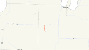
M-137 is a state trunkline highway in the US state of Michigan that serves as a spur route to the Interlochen Center for the Arts and Interlochen State Park. It starts at south of the park and runs north between two lakes in the area and through the community of Interlochen to US Highway 31 (US 31) in Grand Traverse County. The highway was first shown without a number label on maps in 1930 and labelled after an extension the next year. The highway's current routing was established in the 1950s.
Route description
M-137 at the south of Interlochen State Park at an intersection with Vagabond Lane. Farther south, the roadway continues as County Road 137 (CR 137). The state highway is a two-lane road that meanders north, connecting to the front gate of the state park and the Interlochen Center for the Arts. The road runs along the isthmus between Green and Duck lakes north of the Green Lake Airport. North of the school, the highway passes through a wooded section before entering the community of Interlochen itself near the Green Lake Township Hall. There M-137 runs almost due north, crossing a line of the Great Lakes Central Railroad[4] before terminating at its connection with the rest of the state trunkline system at US 31 at Interlochen Corners. The roadway continues north of US 31 as South Long Lake Road after the M-137 designation ends.[5][6]
M-137 is maintained by the Michigan Department of Transportation (MDOT) like other state highways in Michigan. As a part of these maintenance responsibilities, the department tracks the volume of traffic that uses the roadways under its jurisdiction. These volumes are expressed using a metric called annual average daily traffic, which is a statistical calculation of the average daily number of vehicles on a segment of roadway. MDOT's surveys in 2010 showed that 4,868 vehicles used the highway daily.[7] No section of M-137 has been listed on the National Highway System,[8] a network of roads important to the country's economy, defense, and mobility.[9]
History
A highway along the route of M-137 connecting US 31 south to the state park was added to the state highway system during the first half of 1930, initially lacking a designation label on the state maps of the time.[2][3] This routing was extended by 0.9 miles (1.4 km) and labelled as M-137 on maps in 1931.[10][11] The former route through the campus of the Interlochen Center for the Arts was abandoned as a roadway on March 26, 1956, after M-137 was realigned to pass to the east of the school and extended further south through the state park area.[12][13]
Major intersections
The entire highway is in Grand Traverse County.
| Location | mi[1] | km | Destinations | Notes |
|---|---|---|---|---|
| Interlochen | 0.000 | 0.000 | Vagabond Lane CR 137 | Roadway continues south as CR 137 |
| Green Lake Township | 2.884 | 4.641 | Roadway continues north as South Long Lake Road | |
| 1.000 mi = 1.609 km; 1.000 km = 0.621 mi | ||||
See also
 Michigan Highways portal
References
- 1 2 Michigan Department of Transportation & Michigan Center for Shared Solutions and Technology Partnerships (2009). MDOT Physical Reference Finder Application (Map). Michigan Department of Transportation. Retrieved June 25, 2012.
- 1 2 Michigan State Highway Department & H.M. Gousha (January 1, 1930). Official Highway Service Map (Map). [c. 1:810,000]. Lansing: Michigan State Highway Department. OCLC 12701195, 79754957.
- 1 2 Michigan State Highway Department & H.M. Gousha (July 1, 1930). Official Highway Service Map (Map). [c. 1:810,000]. Lansing: Michigan State Highway Department. OCLC 12701195, 79754957.
- ↑ Michigan Department of Transportation (January 2011). Michigan's Railroad System (PDF) (Map). Scale not given. Lansing: Michigan Department of Transportation. Retrieved February 1, 2011.
- ↑ Michigan Department of Transportation (2012). Pure Michigan: State Transportation Map (Map). c. 1:975,000. Lansing: Michigan Department of Transportation. § G8. OCLC 42778335, 794857350.
- ↑ Google (March 25, 2010). "Overview Map of M-1377" (Map). Google Maps. Google. Retrieved March 25, 2010.
- ↑ Bureau of Transportation Planning (2008). "Traffic Monitoring Information System". Michigan Department of Transportation. Retrieved April 8, 2011.
- ↑ Michigan Department of Transportation (April 23, 2006). National Highway System, Michigan (PDF) (Map). Scale not given. Lansing: Michigan Department of Transportation. Retrieved October 7, 2008.
- ↑ Natzke, Stefan; Neathery, Mike & Adderly, Kevin (June 20, 2012). "What is the National Highway System?". National Highway System. Federal Highway Administration. Retrieved July 1, 2012.
- ↑ Michigan State Highway Department & Rand McNally (July 1, 1931). Official Highway Service Map (Map). [c. 1:840,000]. Lansing: Michigan State Highway Department. § G8. OCLC 12701053.
- ↑ Michigan State Highway Department & Rand McNally (October 1, 1931). Official Highway Service Map (Map). [c. 1:840,000]. Lansing: Michigan State Highway Department. § G8. OCLC 12701053.
- ↑ Michigan Department of Transportation & V3 Consultants (August 31, 2001). "Grand Traverse County" (PDF) (Map). Right-of-Way File Application. Scale not given. Lansing: Michigan Department of Transportation. Sheet 24. Retrieved June 25, 2012.
- ↑ Michigan Department of Transportation & V3 Consultants (August 31, 2001). "Grand Traverse County" (PDF) (Map). Right-of-Way File Application. Scale not given. Lansing: Michigan Department of Transportation. Sheet 25. Retrieved June 25, 2012.