Mały Staw
| Mały Staw | |
| Lake | |
 | |
| Country | Poland |
|---|---|
| Region | Lower Silesian Voivodeship |
| Elevation | 1,183 m (3,881 ft) |
| Coordinates | PL 50°44′54.22″N 15°42′3.72″E / 50.7483944°N 15.7010333°ECoordinates: PL 50°44′54.22″N 15°42′3.72″E / 50.7483944°N 15.7010333°E |
| Depth | 7 m (23 ft) |
| Surface area | 2.8 ha (7 acres) |
 Location of Mały Staw within the Central Krkonoše | |
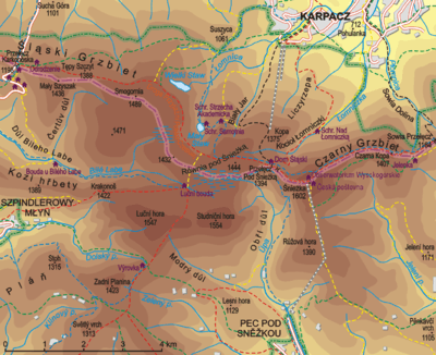
Mały Staw (1,183 m (3,881 ft), Polish for The Small Pond) is a natural lake of glacial origin in the Krkonoše mountains in western Poland. It is situated in the Polish Karkonosze National Park at the bottom of the cirque, on the southern slope of the Smogornia mountain, 1 km south of Wielki Staw.[1]
With its area of 2.8 hectares,[2] it is the second biggest glacial lake in the whole range. Its depth reaches 7 m. The place is accessible from the Polish-Czech Friendship Trail (red marks) and a blue marked short distance trail from Równia pod Śnieżką. A mountain hut Samotnia is situated on the north shore.
References
- ↑ "Kotły Małego i Wielkiego Stawu". Retrieved 2010-01-02.
- ↑ "Kocioł Małego Stawu". Retrieved 2010-01-02.
| Wikimedia Commons has media related to Mały Staw, Krkonoše. |
This article is issued from Wikipedia - version of the 6/7/2015. The text is available under the Creative Commons Attribution/Share Alike but additional terms may apply for the media files.