Macumba River
| Macumba River | |
|---|---|
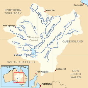 Map of the Lake Eyre Basin showing Macumba River | |
| Country | Australia |
| Basin | |
| Main source |
Macumba Hill 113 metres (371 ft)[1] |
| River mouth |
Warburton River −12 metres (−39 ft) |
| Basin size | 39,000 km2 (15,000 sq mi) |
| Physical characteristics | |
| Length | 145 miles (233 km)[2] |
Macumba River also once known as Treuer River[2] is an ephemeral freshwater stream in the far north of South Australia.
The river rises at the base of Macumba Hill and where the Alberga River joins with Hamilton and Currallulla creeks, it then flows in a south easterly direction entering the Kalamurina Sanctuary and eventually discharges into the Warburton River near the north eastern side of Lake Eyre. The Macumba is situated in an arid region, the Simpson Desert and flows only very rarely. Even in years that Lake Eyre fills, such as 2010, most of the water comes from the west, the Channel Country of Queensland.
The Finke River normally drains into the Simpson Desert to the north west of the Macumba, but in the first decade of the 20th century it is thought that the Finke flowed directly into the Macumba.[3] It is thought that the Finke has flowed to Lake Eyre via the Macumba in 1909, 1938 and 1945.[4]
The Macumba is part of the western rivers catchment of the Lake Eyre Drainange basin along with the Peake Creek and Neales River. The western rivers catchment is composed of sandplains, Acacia scrub, gibber plains and dissected residuals.[5]
Along with its tributaries the river has a catchment area of 39,000 square kilometres (15,058 sq mi).[4]
The river passes through a number of permanent and semi-permanent waterholes including Ross waterhole, Walkinna waterhole, Tidnabucca waterhole, Ullabarracoola waterhole and Christmas waterhole.
There are eleven tributaries of the river including; Alberga River, Stevenson Creek, Coomparana Creek and Yardaparinna Creek.
The river flooded in both 2011 and 2012 with waters discharging into Lake Eyre each time.[6]
The traditional owners of the area are the Arabana and Arrernte peoples, both of whom belong to the Central Australian Desert language group.[7] The Macumba features in the Emu story, which is told in 80 verses. The Arabana word for the Macumba is Maka-Wimpa which means fire track, the Arrernte word is Ura-Ingka which also means fire track, named so as the river bed would be the path followed by bushfires in the area.
John McDouall Stuart was the first european to explore the area in 1859 when he conducted an expedition to the west of Lake Eyre. In 1870 the Australian Overland Telegraph, which crosses the river near Oodnadatta, was being built.[8]
In 1984 the Macumba, along with Neales River and the other western tributaries, filled Lake Eyre south and partially filled Lake Eyre north from there discharge following heavy rains in central Australia.[9]
References
- ↑ 213936&st=&s=Macumba%20River "Bonzle Digital Atlas – Map of Macumba River" Check
|url=value (help). 2012. Retrieved 18 January 2013. - 1 2 G.H. Knibbs (1909). Official Yearbook of the Commonwealth of Australia 1901-1908. Melbourne Victoria: Commonwealth Bureau of Census and Statistics.
- ↑ "State of the Catchment Report – SAAL Region" (PDF). Government of South Australia. 7 March 2006. Retrieved 18 January 2013.
- 1 2 "Floods of Lake Eyre". Dr Vincent Kotwicki. 2005. Retrieved 18 January 2013.
- ↑ "The Lake Eyre Basin and Its Importance" (PDF). 15 June 2001. Retrieved 18 January 2013.
- ↑ "Lake Eyre News". Swagabout Tours. 2012. Retrieved 19 January 2013.
- ↑ Libby Robin (2004). Desert Channels: The Impulse to Conserve. Collingwood, Victoria: CSIRO Publishing. ISBN 9780643103535.
- ↑ Rob Van Driesum (2002). Outback Australia. Melbourne, Victoria: Lonely Planet. ISBN 1864501871.
- ↑ "About Lake Eyre". Gekko Safari. 2012. Retrieved 19 January 2013.
Coordinates: 27°49′58″S 137°14′13″E / 27.832645°S 137.237023°E