Madan Upazila
| Madan মদন | |
|---|---|
| Upazila | |
 Madan Location in Bangladesh | |
| Coordinates: 24°43′N 90°58′E / 24.717°N 90.967°ECoordinates: 24°43′N 90°58′E / 24.717°N 90.967°E | |
| Country |
|
| Division | Mymensingh Division |
| District | Netrokona District |
| Area | |
| • Total | 225.85 km2 (87.20 sq mi) |
| Population (1991) | |
| • Total | 117,613 |
| • Density | 520/km2 (1,300/sq mi) |
| Time zone | BST (UTC+6) |
| Website | Official Map of Madan |
Madan (Bengali: মদন) is an upazila of Netrokona District[1] in the Division of Mymensingh, Bangladesh.
Geography
Madan is located at 24°43′00″N 90°58′00″E / 24.7167°N 90.9667°E. It has 21,808 households and total area 225.85 km².
Demographics
As of the 1991 Bangladesh census, Madan has a population of 117613. Males constitute 50.99% of the population, and females 49.01%. This Upazila's eighteen up population is 58127. Madan has an average literacy rate of 18.7% (7+ years), and the national average of 32.4% literate.[2]
Administration
Madan has 1 Pourashava, 8 Unions/Wards, 95 Mauzas/Mahallas, and 120 villages.
See also
Gallary
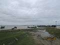 Uchitpur Ghat at Madan.
 Mogra River from the bridge at Madan Upazila.
References
- ↑ Syed Marufuzzaman (2012), "Madan Upazila", in Sirajul Islam and Ahmed A. Jamal, Banglapedia: National Encyclopedia of Bangladesh (Second ed.), Asiatic Society of Bangladesh
- ↑ "Population Census Wing, BBS". Archived from the original on 27 March 2005. Retrieved 10 November 2006.
| Upazila/Thana: | ||
|---|---|---|
Headquarters: Mymensingh | ||
| Jamalpur District | ||
| Mymensingh District | ||
| Netrokona District | ||
| Sherpur District | ||
This article is issued from Wikipedia - version of the 11/13/2016. The text is available under the Creative Commons Attribution/Share Alike but additional terms may apply for the media files.