Maderas
| Maderas | |
|---|---|
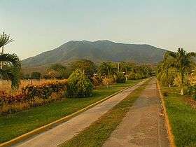 Maderas, as seen from the south (April 2008) | |
| Highest point | |
| Elevation | 1,394 m (4,573 ft) [1] |
| Coordinates | 11°26′46″N 85°30′54″W / 11.446°N 85.515°WCoordinates: 11°26′46″N 85°30′54″W / 11.446°N 85.515°W [1] |
| Geography | |
 Maderas Location in Nicaragua | |
| Location | Rivas Department, Nicaragua |
| Geology | |
| Mountain type | Stratovolcano |
| Last eruption | Unknown |
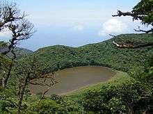
With a height of 1,394 metres (4,573 ft), Maderas is the smaller of the two volcanoes which make up the island of Ometepe, situated in Lake Nicaragua in Nicaragua, Central America. Unlike Concepción, the other volcano on the island, Maderas has not been active in historical times. Its crater contains a crater lake.
The slopes of Maderas are one of the few places on the Pacific side of Nicaragua where cloud forest grows. The only other place where this is found is at the Mombacho volcano. Cloud forests are characterized by a rich plant and animal life, made possible by the high levels of humidity in the climate. Prehistoric petroglyphs have been found at the Maderas volcano.
Climbing to the top of the volcano is a popular tourist activity. Currently, tourists must hire a guide to climb to the top, as several tourists have gotten lost in the past. The hike to the top of the crater can be difficult, with steep inclines that get muddy when it rains. It rains often on Ometepe Island, so a slippery climb is likely, even in the dry season. The return walk takes between 6 and 9 hours.
There are a number of interesting species that dwell on the volcano, including the white-faced monkey, mountain crab, howler monkeys, and a number of butterflies including the well-known blue morphos.
See also
References
- 1 2 "Maderas". Global Volcanism Program. Smithsonian Institution. Retrieved 2006-02-06.
External links
| Wikimedia Commons has media related to Maderas. |
| Guatemala |  | |
|---|---|---|
| El Salvador | ||
| Nicaragua | ||
| Costa Rica |
| |
| Panama | ||
Note: volcanoes are ordered from north-west to south-east. | ||