Mahaica-Berbice
| Mahaica-Berbice Region 5 | |
|---|---|
| Administrative Region | |
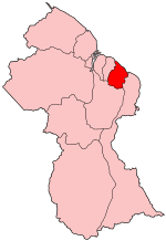 Map of Guyana showing Mahaica-Berbice region | |
| Country | Guyana |
| Regional Capital | Fort Wellington |
| Area | |
| • Total | 4,190 km2 (1,620 sq mi) |
| Population (2012 census) | |
| • Total | 49,723 |
| • Density | 12/km2 (31/sq mi) |
| [1] | |
Mahaica-Berbice (Region 5) is a region of Guyana, bordering the Atlantic Ocean to the north, the region of East Berbice-Corentyne to the east, the region of Upper Demerara-Berbice to the south and the region of Demerara-Mahaica to the west.
It contains the towns of Rosignol, Fort Wellington, Mahaicony and Helena.
The Mahaica River runs along the region's western border. The Berbice River is the eastern border. The Mahaicony and Abary Rivers run south to north.
Population
The Government of Guyana has administered three official censuses since the 1980 administrative reforms, in 1980, 1991 and 2002.[2] In 2012, the population of Mahaica-Berbice was recorded at 49,723 people.[3] Official census records for the population of the Mahaica-Berbice region are as follows:
- 2012 : 49,723
- 2002 : 52,400
- 1991 : 51,280
- 1980 : 53,898
Communities
(including name variants):
- Abary
- Baiabu (Barabara, Biabu, Big Baiabo)
- Bel Air
- Belladrum
- Blairmont (Blairmont Place)
- Bush Lot
- Cotton Tree
- De Hoop
- Esau and Jacob
- First Savannah
- Fort Washington
- Fort Wellington
- Gordon Table
- Governor Light
- Grass Hook
- Helena
- Helena Number Two
- Hopetown
- Ithaca
- Jacoba
- Lichfield (Forty-two)
- Mahaicony (Mahaicony Village)
- Mora Point
- Moraikobe
- Mortice
- New Amsterdam
- New Found Out
- Number 2
- Number 4 (Edderton Village)
- Number 5 (Zeelust Village)
- Number Twelve
- Number Forty Village (Seafield, Forty)
- Number Forty One (Forty-one Village)
- Old Vigilante (Old Vigilantie)
- Perth (Perth Village)
- Pine Ground
- Rising Sun
- Rosignol
- Saint Francis Mission
- Saint John
- Sinking Ground
- Sir James
- Tempe
- Vigilantie (De Vigilante)
- Weldaad
- Kuru Kururu
- Washington
See also
References
- ↑ Macmillan Publishers (2009). "Administrative Regions - 5 and 6". Macmillan Junior Atlas: Guyana. Oxford: Macmillan Caribbean. p. 35. ISBN 9780333934173.
- ↑ Beaie, Sonkarley Tiatun (19 September 2007). "Chapter 3: National Redistribution and Internal Migration". 2002 Population and Housing Census - Guyana National Report. Bureau of Statistics. p. 51. Archived from the original (PDF) on 2 September 2012. Retrieved 29 August 2012.
- ↑ Beaie, Sonkarley Tiatun (19 September 2007). "National Population Trends: Size, Growth and Distribution" (PDF Download). 2002 Population and Housing Census - Guyana National Report. Bureau of Statistics. p. 25. Retrieved 29 August 2012.
Coordinates: 6°13′46″N 57°53′13″W / 6.229522°N 57.886845°W