Makati Avenue
 | |
| Length | 2.3 km (1.4 mi) |
|---|---|
| Location | Makati, Metro Manila |
| From | Makati-Mandaluyong Bridge in Poblacion |
| Major junctions |
J.P. Rizal Avenue Kalayaan Avenue Gil Puyat Avenue Paseo de Roxas Ayala Avenue |
| To | Arnaiz Avenue in San Lorenzo Village |
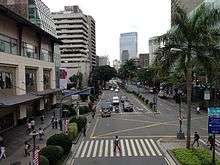
Makati Avenue is a major commercial thoroughfare in Makati, Metro Manila, Philippines. It forms the eastern border of Ayala Triangle and is one of the three main avenues of the Makati Central Business District. The avenue runs in a somewhat north-south diagonal direction almost parallel with Epifanio de los Santos Avenue (EDSA). It passes through two distinct neighborhoods of the city: the Makati CBD and the old Makati Población. At its northern end lies the older part of Makati starting from the Makati-Mandaluyong Bridge and J.P. Rizal Avenue. It continues through Población to Gil Puyat Avenue, marking the southern edge of the old district. South of Gil Puyat onto the CBD, the avenue becomes more commercial and upscale. The shopping hub of Ayala Center and Arnaiz Avenue lie at its southern end.
Makati Avenue has two lanes each way in the Poblacion area, widening to three or four in the CBD. It has a short extension into the gated San Lorenzo Village as San Lorenzo Drive.
History
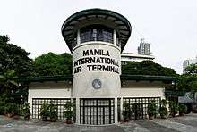
The avenue served as the primary access road to the old Nielson Field airport from San Pedro de Macati. It was known as Culi-Culi Road which also lead to the barrio of Culi-Culi (now Pio del Pilar) just west of Nielson Field.[1] When the airport was closed down after World War II, its two runways were converted into wide roads known today as Ayala Avenue and Paseo de Roxas. The airport's control tower was preserved and is now a library called Filipinas Heritage Library.[2] This library is located along the avenue at the southeast corner of Ayala Triangle.
Makati Avenue, particularly its northern segment in Poblacion, has a history of prostitution. The areas around P. Burgos Street with its nightclubs, bars and budget hotels are considered by many as the red light district of Makati.[3][4] At present, however, the area is undergoing gentrification with the completion of several new commercial developments including the Century City mall and complex.[5]
Intersections
| City | Barangay | Km | Mi | Destination | Notes | ||
|---|---|---|---|---|---|---|---|
| Makati | San Lorenzo | Arnaiz Avenue | Traffic light intersection. Southern terminus. Road continues south as San Lorenzo Drive | ||||
| San Lorenzo-Urdaneta-Bel-Air boundary | Ayala Avenue | Traffic light intersection | |||||
| South end of DPWH maintenance | |||||||
| Urdaneta-Bel-Air boundary | Paseo de Roxas | Traffic light intersection | |||||
| Bel-Air | Gil Puyat Avenue | ||||||
| Urdaneta-Poblacion boundary | P. Burgos | ||||||
| Poblacion | Kalayaan Avenue | ||||||
| J.P. Rizal Avenue | |||||||
| Makati-Mandaluyong Bridge (Pasig River) | |||||||
| Mandaluyong | Hulo | Coronado Street | Continuation to Mandaluyong. Northern terminus. | ||||
| 1.000 mi = 1.609 km; 1.000 km = 0.621 mi | |||||||
Landmarks


Makati CBD
- Ayala Museum
- Ayala Triangle Gardens
- Fairmont Hotel Manila
- Filipinas Heritage Library
- Greenbelt Chapel
- Greenbelt Mall
- Makati Shangri-La, Manila
- Mandarin Oriental Manila
- New World Makati Hotel
- Pacific Star Building
- Raffles Hotel Manila
- The Landmark (department store)
- The Link (mall)
- The Peninsula Manila
- Zuellig Building
Poblacion
- A. Venue Mall
- Berjaya Hotel
- Best Western Antel
- Century City Mall
- Gramercy Residences
- St. Giles Hotel
References
- ↑ "Ayala Now April–June 2015" (PDF). Ayala Corporation. Retrieved 27 October 2015.
- ↑ History of FHL published by Filipinas Heritage Library; accessed 8 September 2013.
- ↑ Flesh trade thrives in Makati published by Trafficking.org.ph; accessed 8 September 2013.
- ↑ Makati now a sin city published by Inquirer.net; accessed 8 September 2013.
- ↑ Century City Mall to set the stage for a shopping district North of Makati published by Manila Standard Today; accessed 8 September 2013.
| Towers |
|  | ||||||
|---|---|---|---|---|---|---|---|---|
| Ayala Center | ||||||||
| Other landmarks | ||||||||
| Education | ||||||||
| Transportation |
| |||||||
Italics denote buildings under construction or planned. | ||||||||
| Century City |  | |
|---|---|---|
| Rockwell Center | ||
| Other landmarks | ||
| Education | ||
| Transportation | ||
Italics denote buildings under construction or planned. | ||
Coordinates: 14°33′31″N 121°1′35″E / 14.55861°N 121.02639°E