Malatya Province
| Malatya Province Malatya ili | |
|---|---|
| Province of Turkey | |
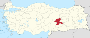 Location of Malatya Province in Turkey | |
| Country | Turkey |
| Region | Central East Anatolia |
| Subregion | Malatya |
| Government | |
| • Electoral district | Malatya |
| Area | |
| • Total | 12,313 km2 (4,754 sq mi) |
| Population (2010-12-31)[1] | |
| • Total | 740,643 |
| • Density | 60/km2 (160/sq mi) |
| Area code(s) | 0422 |
| Vehicle registration | 44 |
Malatya Province (Turkish: Malatya ili) is a province of Turkey. It is part of a larger mountainous area. The capital of the province is Malatya (in Hittite: Milid or Maldi, meaning "city of honey"). Malatya is famous for its apricots. The area of Malatya province is 12,313 km². Malatya Province had a population of 853,658 according to the results of 2000 census, whereas in 2010 it had a population of 740,643. The provincial center, the city of Malatya, has a population of 426,381 (2010).Turks are majority in the province.[2]
Geography
Malatya is traversed by the northeasterly line of equal latitude and longitude.
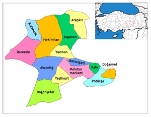
Districts
Malatya province is divided into 14 districts (capital district in bold):
- Akçadağ
- Arapgir
- Arguvan
- Battalgazi
- Darende
- Doğanşehir
- Doğanyol
- Hekimhan
- Kale
- Kuluncak
- Malatya
- Pütürge
- Yazıhan
- Yeşilyurt
Local sites
- İnönü University (since 1975)
- Turgut Özal Medical Center (in İnönü University)
- Malatya Erhaç Airport (serving both public and military)
- Eskimalatya (old city centre, very historical place)
References
- ↑ Turkish Statistical Institute, MS Excel document – Population of province/district centers and towns/villages and population growth rate by provinces
- ↑ http://ahmetalgul.blogcu.com/malatya-nin-sosyal-kulturel-siyasal-ve-ekonomik-yapisi/9376466
External links
| Wikimedia Commons has media related to Malatya Province. |
- (Turkish) Malatya governor's official website
- (Turkish) Malatya
- (Turkish) Malatya municipality's official website
- (English) Malatya weather forecast information
- (English) Malatya directory
| ||
Metropolitan municipalities are bolded. | ||
Coordinates: 38°29′03″N 38°08′11″E / 38.48417°N 38.13639°E
This article is issued from Wikipedia - version of the 5/27/2016. The text is available under the Creative Commons Attribution/Share Alike but additional terms may apply for the media files.