Malpas Tunnel
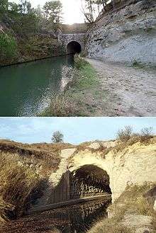
The Malpas tunnel was excavated in 1679 under the hill d'Ensérune in Hérault, allowing the passage of the Canal du Midi. It was Europe's first navigable canal tunnel and a monument to the determination of Pierre-Paul Riquet, the chief engineer. It is located in the commune of Nissan-lez-Ensérune. The Oppidum d'Ensérune is located on the surface a short distance from the tunnel.
There was great disappointment when the works reached the hill d'Ensérune. A few metres of digging in hard rock revealed a very brittle sandstone subject to slippage. Colbert, the prime minister, halted the works when he was made aware of the situation. The portal was blocked and the workings re-sited. Riquet's detractors took advantage of this situation to impede the project. Colbert announced that he would send royal commissioners to decide the canal's future. The advice of the Chevalier de Clerville, architect to Louis XIV, was to cross the River Aude rather than tunnel through the hill. Riquet, however, maintained his preference for a tunnel because of the extra problems that crossing the Aude would create.
Riquet's response was to ask his master mason, Pascal de Nissan, to continue tunneling in secret despite the risk of collapse. In less than eight days the tunnel was complete with a concrete ceiling throughout. The tunnel is 165m long with an arch 8m above the canal's surface,[1] and removed the necessity for an extra lock.
By the time the Malpas Tunnel was excavated in the seventeenth century, the hill had already for several centuries been the site of a tunnel, dug in the Middle Ages, to drain the Étang de Montady. This pre-existing tunnel is said to have been Riquet's inspiration for the Malpas Tunnel. In the nineteenth century, a third tunnel was excavated, passing through the Hill d'Ensérune beneath the Malpas tunnel to house the Béziers to Narbonne railway line.
References
Further reading
- Roland, Claudine (1997). The Canal du Midi (English Translation ed.). MSM. ISBN 2-909998-66-5.
See also
External links
- Le tunnel de Malpas in French
- La percée de Malpas in French
- Tunnel du Malpas in French
- Le Tunnel de Malpas in French
Coordinates: 43°18′26″N 3°7′36″E / 43.30722°N 3.12667°E