Mansbridge
| Mansbridge | |
.jpg) Housing in Mansbridge, 2016 |
|
 Mansbridge |
|
| Unitary authority | Southampton |
|---|---|
| Ceremonial county | Hampshire |
| Region | South East |
| Country | England |
| Sovereign state | United Kingdom |
| Post town | SOUTHAMPTON |
| Postcode district | SO18 |
| Dialling code | 023 |
| Police | Hampshire |
| Fire | Hampshire |
| Ambulance | South Central |
| EU Parliament | South East England |
| UK Parliament | Southampton Itchen |
Coordinates: 50°56′14″N 1°21′52″W / 50.9372°N 1.3645°W
Mansbridge is a suburb on the northern perimeter of Southampton, England. The area is named after the Mans Bridge which spans the River Itchen. For a considerable time, this was the southern-most crossing point of the river, before the construction of Woodmill in Swaythling. The bridge itself still stands and is a Grade II listed structure[1] but is closed to road traffic (pedestrians and cyclists may still use it), having been replaced by a larger and more modern road bridge to carry the A27.
The suburb contains a mixture of housing. The first developments, on the north side of the A27, were designed by architect Herbert Collins, whose houses are a feature of several other Southampton districts. A larger estate was later constructed on the south side, along with Mansbridge Primary School, the logo of which is the bridge itself. The residential area of Mansbridge is bordered to the west by the London to Weymouth railway line and to the east by the river. Beyond the river, Mansbridge takes on a much more rural air, with woodland to the south and water meadows to the north.
The neighbouring areas are Swaythling to the west, Townhill Park to the south, and Chartwell Green to the east. A strip of green belt land separates Mansbridge from Eastleigh to the north.
History
The bridge
There has been a bridge at Mansbridge since at least the year 932, when it was referred to as Mannysbrigge in King Athelstan's charter to the prior of St. Swithun's Priory in Winchester.[2] In the Domesday Book of 1086, the location was recorded as Manebrige or Manesbrige Hundred, within the county of Hantscire.[3] A wooden bridge by the name of Blak Bridge was described as being "a little above Woodmill" (i.e. upstream of Woodmill in Swaythling) by Leland in 1535-43, and this may be a reference to Mansbridge as there are no known crossing points of the river between Mansbridge and Woodmill.[2] Saxton's map of 1575 shows the bridge at Mansbridge labelled as "mans bridge",[2] while Speed's 1611 map refers to the hundred as Mansbridg.[3] Blaeu's 1645 map shows Mansbridge Hundred but Morden's map of 1695 labels the bridge "Mansbridg", and shows it within the Fawley or Waltham (possibly Bishop's Waltham) Hundred.[2][3] However, the bridges that stand at Mansbridge today are much more recent than those mentioned above; the older of the two was built in 1816 by the county council; this bridge was made of stone with a single segmental arch and decorated with a lambswool pattern.[2][4]
The current bridge carrying the A27 road was constructed in 1975, and replaced a bailey bridge erected during the Second World War.[5]
The Grange
The suburb of Mansbridge had at its heart, for a century, a large house called "The Grange." The Grange had an extensive ornamental garden, containing a diverse collection of trees. After World War II the house fell into disrepair, and was eventually demolished around 1970. The grounds are now a part of the Monks Brook Greenway, a nature trail, and many of the original trees can still be seen along the brook's bank.[6]
Gallery
 The bridge after which the suburb is named
 The White Swan public house in Mansbridge
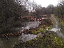 Lock conservation work in progress at Mansbridge Lock on the Itchen Navigation
References
- ↑ "Listed Buildings in Southampton" (PDF). Southampton City Council. p. 90. Retrieved 14 November 2009.
- 1 2 3 4 5 Norgate, Martin and Jean (2001). "Mans Bridge". Old Hampshire Gazetteer. University of Portsmouth. Retrieved 2009-02-19.
- 1 2 3 Norgate, Martin and Jean (2001). "Mansbridge Hundred". Old Hampshire Gazetteer. University of Portsmouth. Retrieved 2009-02-19.
- ↑ "Mans Bridge". List entry. English Heritage. Retrieved 16 April 2012.
- ↑ Course, Edwin (2011). The Itchen Navigation. Hampshire Industrial Archaeology Society. pp. 14–15. ISBN 978-0-905280-10-3.
- ↑ A History of Mansbridge 1990, book, P. Wilson
Areas and suburbs of Southampton | |||||||||
|---|---|---|---|---|---|---|---|---|---|
| |||||||||
| Southampton Itchen |
| ||||||||
| Southampton Test | |||||||||
| Romsey and Southampton North | |||||||||
| |||||||||