Manston, Leeds

Coordinates: 53°48′27″N 1°26′43″W / 53.80758°N 1.445395°W
Manston is an area to the east of Cross Gates, Leeds, England, that lies 4 miles (6 km) to the east of Leeds city centre. The area falls within the Cross Gates and Whinmoor ward of Leeds Metropolitan Council.
Manston is a residential area with its own park, Manston Park, and had a pub named after it, the Manston hotel, which is now known as The Barnbow, next to the park. It has a Parish Church (St. James's) and is also home to three primary schools, Manston Primary, Manston St James Primary Academy and St Theresa's Catholic Primary. Many streets in the area are named after Manston, such as Manston Crescent and Manston Grove. The Leeds Ring Road also passes by the area, providing a vital route into the city centre from Cross Gates.
Comparison
Manston lies in the LS15 postcode area. Here is a population breakdown of the postcode area in comparison with the UK population.
| Category | LS15 | UK average |
|---|---|---|
| Population density (people / sq mi) | 43.2 | 24.9 |
| Gender split (females / male) | 1.05 | 1.05 |
| Average commute | 6.1 miles | 8.73 miles |
| Average age | 38 | 39 |
| Home ownership | 16% | 16.9% |
| Student population | 2.4% | 4.4% |
| People in good health | 69% | 69% |
Gallery
Images of Manston
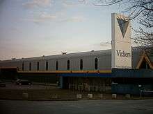 The Vickers works
 The old Optare bus factory in Manston
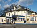 The Manston public house, now called The Barnbow
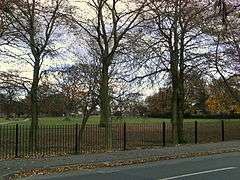
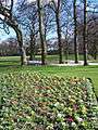 Manston Park
External links
- The Ancient Parish of Whitkirk at GENUKI: Manston was in this parish